Dense tropical rainforests hide the past very effectively. Trees sprout over roads, roots break down walls, leaves cover platforms with debris, and landscapes gradually vanish under a dense green foliage. Seen from the surface, what appeared to be a human-made urban layout merges seamlessly with pristine wilderness. Hence, archeologists have turned to airborne laser mapping called LiDAR that reveals what cannot be seen otherwise. Lasers penetrate the gaps in the greenery of tropical rainforests and allow for reconstructing the topography of the landscape below.
Suddenly, one sees clearly the road networks, terraces, causeways, platforms, and geometrically arranged settlements previously invisible during foot surveys due to dense foliage or difficult access. It is not uncommon for this technique to create an instantaneous revelation as the transformation happens within seconds on a computer screen. An uninterrupted expanse of forest gives way to a well-defined network of lines, elevated structures, and human settlements that were obscured by jungle foliage for centuries.
According to NASA's Earth Observatory, LiDAR creates topographic maps using lasers reflected back off leaves, branches, and ultimately the ground surface. After removing the data on vegetation from a digital terrain map, one obtains topographic features previously hidden under the forest foliage.
The significance of the technology can be explained by its potential for scale. Prior archaeological surveys of tropical forests involved manual vegetation clearance and mapping of buildings one at a time, which was both costly and inefficient. The use of LiDAR technology has enabled rapid surveying of vast landscapes without disrupting the environment. As described in studies published in Nature and NASA publications, LiDAR has enabled scientists to realize that ancient tropical civilizations were bigger, more connected, and denser than they had assumed before.
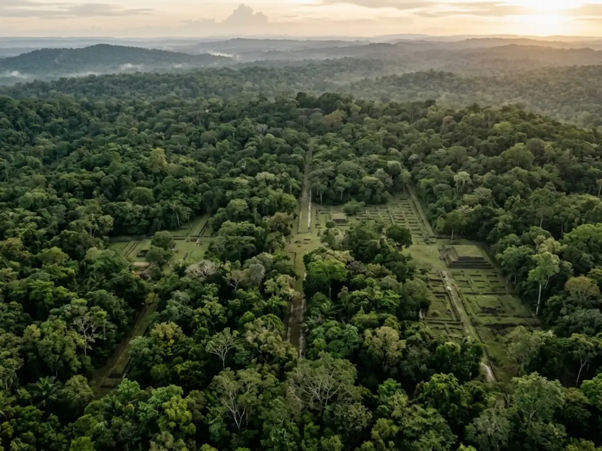
The buried city patterns become visible once the trees disappear from the data
Another factor responsible for making LiDAR useful for archeologists is the fact that landscapes shaped by humans usually exhibit distinct geometrical patterns. Linear roads, raised platforms, fortified structures, and other man-made formations tend to stand out once plants have been digitally stripped away. While they may not look very distinct from the ground due to many years of regrowth, such structures can actually turn up on maps generated from LiDAR images quite easily.
This became clear when reviewing the work of archeologists investigating the urban civilization of the ancient Maya described in an article published by Nature in 2022. LiDAR surveys showed that there existed extensive urbanized areas within a tropical forest that were previously unknown to researchers. Such areas included road networks, reservoirs, agricultural terraces, fortified settlements, and much more.
This is significant in history because the tropical cities of the past were not constructed in a manner similar to that of the dense stone cities found in Europe. Settlements sprawled out into interconnected complexes, causeways, raised areas for agriculture, and ritualistic centers that were all connected. Thick vegetation made the pattern invisible to human eyes until LiDAR was introduced, which made the entire landscape readable once again. Scientists remind us, though, that using LiDAR does not mean that excavations are no longer needed.
For instance, if a LiDAR image shows a suspicious pattern, scientists must conduct an on-site inspection to verify that the structure is indeed man-made, determine its origin date, and identify its function. Landforms sometimes resemble man-made structures. As described in the discussion on archaeological remote sensing in Nature Index, the best scientific results come from the combination of aerial observations with digging, sample analysis, and environmental research around the area. This means that LiDAR should not be viewed as sorcery but as a guide in a complicated world of ruins.
LiDAR is changing how archaeologists think about lost cities themselves
One of the reasons why these findings are intriguing is that they bring to light different views on the nature of ancient urban centers in such areas. For many years, lost cities have been viewed as separate rock formations covered up by plants. Recent archaeological findings show otherwise; large planned environments with infrastructure, roads, terraces, and settlements sprawling from the well-known monument complexes have come to light.
In addition, the technology marks yet another change in archaeological studies towards non-destructive exploration. Clearing a path through thick forests might harm the environment and the site in question. Archaeologists using LiDAR technology can map out an area and identify locations requiring excavation without causing too much disturbance. In fact, according to an article in npj Heritage Science published in 2026, remote sensing technologies like LiDAR have been established as necessary equipment in identifying cultural heritage under vegetation cover.
Here's a further explanation for why people react the way they do towards the scans: they help bring about history, which was hitherto hidden. The jungle that looks very untidy visually reveals itself to be an orderly map of a city, complete with all its streets, buildings, platforms, and planning. This is a feeling as though one has peeled back time. However, the archaeologists say that the cities have been there all along.
It is just that now science has made it possible to uncover what had been invisible to us. Thus, the appearance of cities lying under jungles should be considered not only as something exciting but as a great leap forward in archaeological methodology. It has changed the way in which historians work on understanding ancient urban life; it has revolutionized the way people look for artifacts in difficult terrain; it has transformed the way in which hidden sites are interpreted before any excavation at all.