A new weather system, named Storm Pedro by forecasters, is set to bring snow and heavy rain to the UK this week.
The latest naming comes from Meteo France, the French national weather service, which predicts the storm will have a drastic effect.
On this side of the Channel, however, the impact of Storm Pedro is likely to be relatively minor, with snow mainly confined to the hills.
Yellow weather warnings are in place for Wednesday and Thursday across parts of the country, predicting bouts of snow, rain and ice.
The Met Office said: “There is the potential for an area of rain and snow to affect parts of Wales, central England and into the southern Pennines during Wednesday evening and overnight into Thursday.”
Some ice is also likely to develop on untreated surfaces across parts of Wales and western England.
The areas where rain, sleet and snow is forecasted will gradually clear to the east during Wednesday evening and early Thursday morning, and temperatures will fall close to, or a little below, freezing,
The Met Office has also issued a rain and snow warning for Northern Ireland from 4am Wednesday until 8pm Wednesday. Outbreaks of rain, hill snow and strong winds may bring some disruption to travel, the forecasters warn.
There is a slight chance of the weather causing travel delays on roads with some stranded vehicles and passengers, along with delayed or cancelled rail and air travel. There is also a small chance of rural communities experiencing power cuts or outages to phone services.
The Met Office said: “An area of rain, falling as snow over some high ground, will move slowly east across much of Northern Ireland during Wednesday, before tending to ease later in the day. This will be accompanied by strong southeasterly winds which may gust 45-55mph in places, particularly during the morning. Rainfall totals of 10-15mm are predicted fairly widely, with 20-30mm in some southern and western areas.”
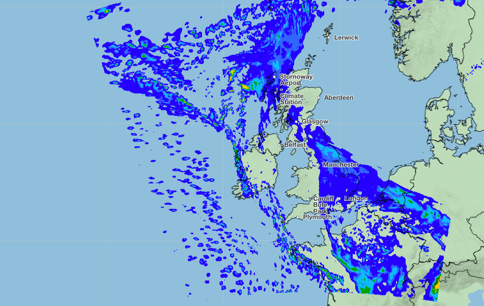
The snow will mainly accumulate on higher ground above 250m, mainly over the Sperrins during the morning, with little if any lying snow.
There will be some spells of heavy rain affecting southern parts of England during Wednesday and overnight into Thursday, while some snow is also likely over higher ground, mainly during Wednesday night.
This will be accompanied by strong, east to northeasterly winds, which could exacerbate the impact in places. Large waves could affect some east-facing coasts, particularly along the English channel.
The Met Office has advised residents to prepare flood kits filled with torches, batteries, mobile phone power packs and other essential items.
Despite a period of rain and gloomy weather, the temperatures are expected to pick up again towards the weekend, reaching highs of 14C in Exeter on Saturday, according to Met Office.
More follows...
Terrifying moment massive avalanche smothers crowd of fleeing skiers in Italian Alps
Storm Pedro map: Where snow and ice will hit UK this week
Storm Pedro brings flooding to France as Spain braces for 11th big storm in six weeks
Nine skiers missing in Lake Tahoe avalanche: Six others rescued in ‘extreme weather’
Third Briton among six killed in wave of avalanches in French Alps
Reform would restore two-child benefit cap in full, Jenrick to pledge