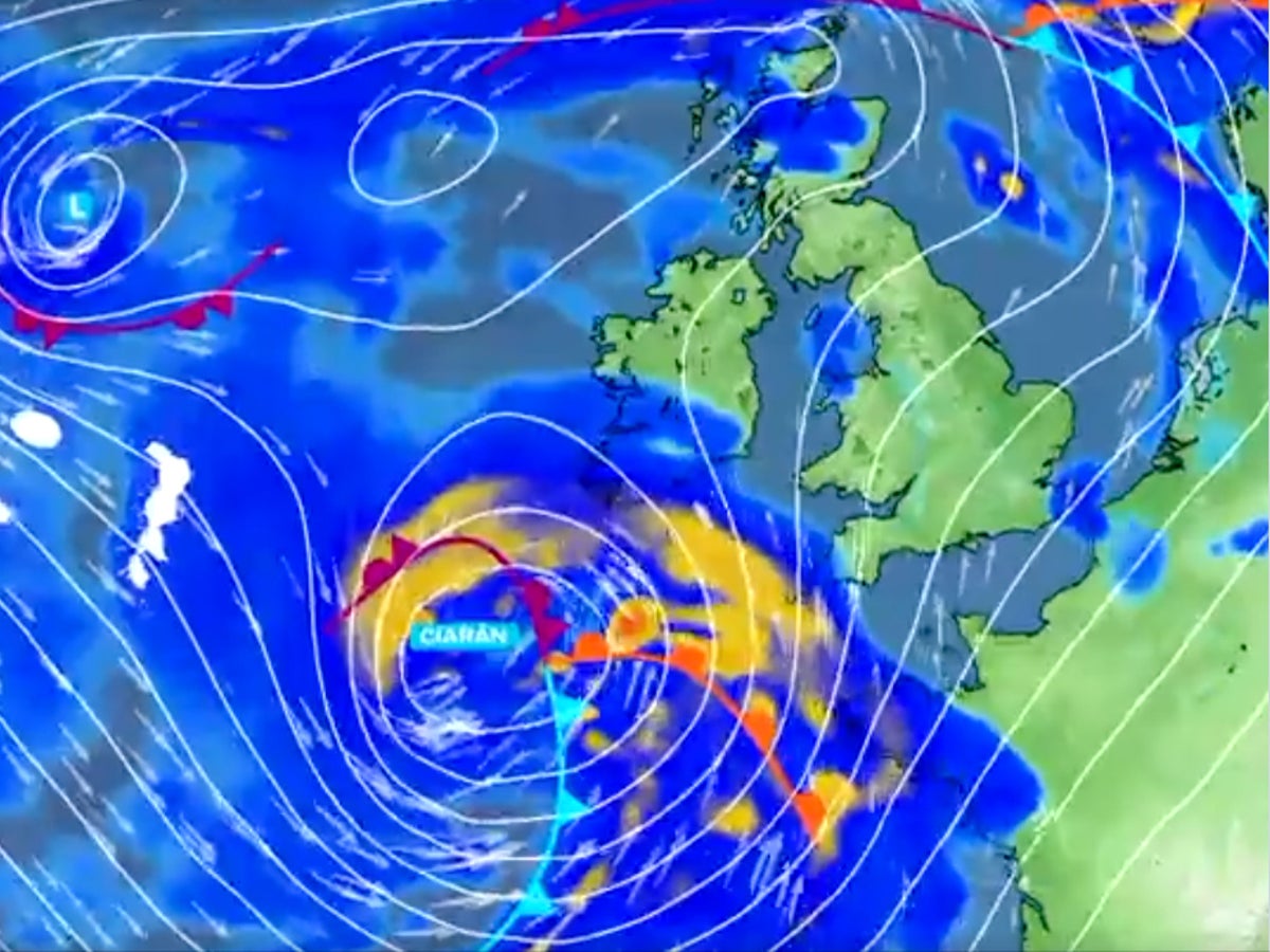
Storm Ciaran is causing widespread travel chaos, with cancellations and delays expected to last until Saturday as the UK braces for the weather event to hit.
The Met Office has issued two amber “danger to life” warnings, the second-highest level of alert, across England and Wales as heavy rain and strong winds started lashing the UK from Wednesday evening, prompting flights to be grounded and trains and ferry journeys to be shelved.
Met Office spokesperson Oli Claydon said the storm would bring coastal gusts of 70mph to 80mph and the potential for 85mph, with people urged to stay away from the water’s edge due to “very dangerous conditions”.
Northern Ireland has already seen flooding; a yellow rain warning from the Met Office was in place for the country until 9am on Wednesday.
The worst conditions are at sea, with warnings that waves in the Bay of Biscay could reach 14 metres (45ft) off the coast of Brittany. French forecasters are warning that gusts could exceed 160km/h (100mph).
Brittany Ferries have cancelled all UK-Spain voyages planned to cross the Bay of Biscay on Thursday. A ferry industry insider said: “The Bay of Biscay and Irish Sea is a monster. In the English Channel it’s a bit more like a bull in a china shop, with the worst damage expected throughout Thursday as the storm hammers through from west to east.”
All sailings by DFDS Ferries between the UK and France have been cancelled until Friday morning. The line normally links Dover with both Calais and Dunkirk. But the company said: “We regret to inform that sailings from the 11.59pm departure on 1 November until and including the 2am departure on 3 November have been suspended due to the extreme weather conditions.”
Affected passengers can contact the firm to rebook.
More rain and strong winds are predicted as Storm Ciaran approaches the UK— (PA Wire)
Earlier, DFDS said its Newhaven-Dieppe link would be suspended for 24 hours from Wednesday evening.
Condor Ferries have cancelled their sailings to and from Jersey until Saturday. The island’s airport is to be closed all day on Thursday, leading to the cancellation of dozens of flights including four to and from London Heathrow.
Passengers were told: “Airport authorities have decided to close the airport to commercial operations all day on Thursday. The airport will remain open for emergency and medical flights, and will reopen on Friday after a visual inspection of the airport infrastructure.”
Heathrow airport, the busiest in the UK, is seeing many other cancellations. British Airways have grounded 30 domestic and European flights, including two round trips to Amsterdam, two to Belfast City and two to Paris CDG. Passengers are being rebooked on other services, or can take a full refund.
In addition, KLM has cancelled five round trips between Amsterdam and Heathrow as a result of reduced runway capacity at the Dutch airport.
Thousands of passengers hoping to connect from other UK airports at Amsterdam Schiphol are also learning that their flights on Thursday have been cancelled.
KLM Royal Dutch Airlines told passengers: “Due to the expected weather conditions at Amsterdam Airport Schiphol, the runway capacity has been reduced on Thursday 2 November. As a result, some of our flights have been cancelled. We apologise for any inconvenience.”
A woman tries to walk through water as it flows through the streets after heavy rain caused extensive flooding in Ireland— (Reuters)
All 17 UK airports served by KLM, from Bristol to Inverness, have had some departures and arrivals grounded. Almost 50 flights to and from Amsterdam are affected. London City, London Heathrow and Manchester are the worst hit.
Passengers are entitled to be rerouted free of charge, with KLM providing hotels and meals as necessary until they reach their destination.
And train operators from southwest England and Wales to Scotland are expecting widespread disruption.
Network Rail said: “Heavy rain accompanied by strong winds in some areas could affect journeys across Wales, the south of England and the Midlands on Thursday, and across the northeast of England and central and eastern Scotland on Thursday and Friday.
“Owing to the adverse weather conditions, passengers should allow extra time for their journeys and check before travelling as services may be disrupted.”
Great Western Railway (GWR) is advising passengers not to travel in Cornwall until at least noon on Thursday. It has cancelled all trains on the main line west of St Austell towards Penzance, as well as branch lines, during that spell.
“To help people make their journey, those with tickets for Wednesday evening will be able to travel earlier in the day,” GWR said. “Services may be subject to short-notice cancellation or alteration across the Great Western Railway network on Thursday 2 November, as Storm Ciaran is forecast to bring more rain and strong winds.
“The storm will also affect the road network, with poor road conditions and possible closures likely to impact the provision of rail replacement transport.”
Storm Ciaran is set to bring a fresh bout of wind and rain to the UK – with ‘danger to life’ amber weather warnings issued for Thursday— (PA Wire)
On the East Coast Main Line, connecting London King’s Cross with Yorkshire, northeast England and Scotland, LNER has warned that disruption to services due to Storm Ciaran will continue until at least Saturday 4 November – and is urging passengers not to attempt to travel on Thursday or Friday.
The train operator said: “We strongly advise customers to avoid travelling on Thursday 2 November and Friday 3 November.
“Some LNER trains will be running, but there is likely to be major disruption including severe delays, short-notice cancellations and overcrowding. There may be service alterations on Saturday 4 November as we work towards reinstating our normal timetable.”
In France, all regional express trains in the Hauts de France region – stretching from north of Paris to Calais and Dunkirk – have been cancelled. The train operator warned: “Exceptional phenomena are expected, with forecasts of violent winds in the north of France. In order to guarantee the safety of travellers and staff, a total interruption of TER Hauts-de-France traffic is planned for Thursday 2 November all day, with possible consequences on Friday 3 November in the morning.”


