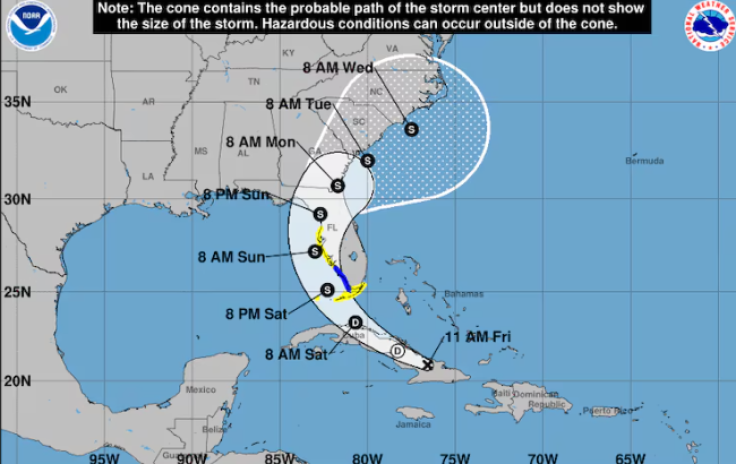
MIAMI, FL – A developing tropical system in the eastern Gulf of Mexico is expected to bring significant weather impacts to Florida and much of the southeastern U.S. this weekend. The National Hurricane Center has issued tropical storm warnings from near Fort Myers to the southern tip of the Everglades, with tropical storm watches extending to the remainder of the Keys and the south coast of Florida up to just north of Tampa.
As of Friday morning, the system, currently located over Cuba and with winds of 30 mph, shows signs of strengthening. Satellite imagery indicates increasing convection, a sign that the storm is beginning to organize. The storm, likely to be named Debby, could intensify into a hurricane before making landfall late this weekend or early next week.
The path of the storm
The exact path remains uncertain, but current models suggest various possibilities. A more western trajectory could allow the storm to gather strength over the hot waters of the eastern Gulf of Mexico, potentially impacting the Florida Panhandle, southern Alabama, or coastal Mississippi. A more eastern path would bring earlier landfall and possibly affect South Florida directly.
.@NHC_Atlantic is monitoring a tropical wave that is expected to move into the southeastern Gulf of Mexico on Saturday, where development into a tropical storm is forecast for Saturday. Should this occur, the storm will be named #Debby.
— National Weather Service (@NWS) August 2, 2024
Heavy rainfall may result in flash and… pic.twitter.com/2in90F7meW
Regardless of its exact track, the system is expected to bring heavy rainfall, strong winds, and rough surf to the affected areas. The National Hurricane Center warns of possible flash and urban flooding, with some locations potentially receiving a foot or more rain. The combination of hot sea surface temperatures and conducive atmospheric conditions suggests that this storm could rapidly intensify.
Residents in the warning areas are advised to prepare for potential power outages, flooding, and other storm-related disruptions. Coastal regions should be particularly vigilant for storm surges and high winds.
Forecast and Preparedness
Meteorologists at Colorado State University predict an active hurricane season with up to 25 named storms. The ongoing La Niña pattern, characterized by warmer sea surface temperatures and favorable wind patterns, is expected to contribute to the high activity.
Authorities urge residents to stay informed through official channels and to heed local evacuation orders if issued. Preparations should include securing property, preparing an emergency kit, and planning for potential evacuations.
The last significant hurricane to impact the Gulf of Mexico was Hurricane Ian in September 2022. Ian, a powerful Category 4 storm, made landfall on the southwestern coast of Florida, near Fort Myers, bringing catastrophic winds, storm surge, and heavy rainfall. The hurricane caused widespread damage, flooding, and power outages, affecting millions of residents. Ian's path through the Gulf and its subsequent impact on the southeastern United States underscored the region's vulnerability to intense tropical systems, prompting renewed emphasis on hurricane preparedness and resilience measures.
© 2024 Latin Times. All rights reserved. Do not reproduce without permission.


