Parts of the UK are bracing for significant snow showers on Friday, following a day of blustery conditions across much of the UK.
The Met Office has issued a yellow weather warning for snow and ice, effective from Friday morning, encompassing areas north of Stirling and around Fort William. Up to 5cm of snow is anticipated across the region, with higher elevations potentially seeing as much as 10cm.
A Met Office forecaster explained: "Blustery wintry showers will affect central and north-west Scotland during Thursday afternoon and evening but are expected to become more frequent during the second half of the night before easing on Friday morning. Two to 5cm of snow is expected fairly widely across the area, with 10cm possible in places above about 350 metres."
The warning remains in place until 9am on Friday, with authorities cautioning about potential travel disruption and hazardous icy surfaces.
⚠️ Yellow weather warning issued ⚠️
— Met Office (@metoffice) March 12, 2026
Snow and ice across central parts of Scotland
Friday 00:00 to 09:00
Latest info 👉 https://t.co/QwDLMfRBfs
Stay #WeatherAware⚠️ pic.twitter.com/AO5eNAQdlY
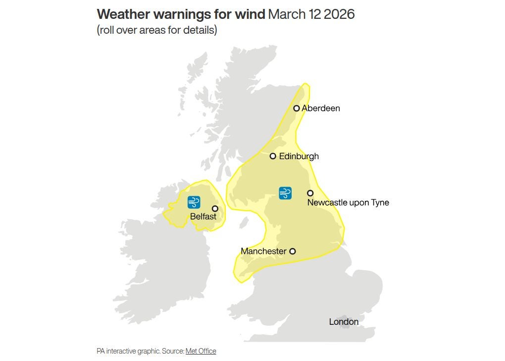
On Thursday, a yellow warning of wind is in place for central, southern and north-eastern Scotland, as well as the north of England. A separate yellow warning for wind is in place for Northern Ireland.
Forecasters said that in Scotland and England, gusts of 50-55mph are expected widely, while some coastal areas and places downwind of high ground could see gusts of 60mph or even 70mph.
They warned of potential delays to road, rail, ferry and air transport and said there may be some short-term loss of power and other services.
ScotRail warned passengers that journeys may take a little longer as Network Rail Scotland has put speed restrictions in place on some routes due to the conditions.
Speed restrictions are in place on the West Highland Line, the Highland Main Line and the Far North and Kyle Lines.
Some Caledonian MacBrayne ferry services on Scotland’s west coast have been disrupted due to the windy conditions.
In Aberdeenshire, the A90 was blocked in both directions at Fordoun for a time due to a fallen power line, which was lying across both the north and southbound carriageways, before being cleared just after 9am.
The wind warning for Scotland and England is in place until 8pm on Thursday.
⚠️ Your journey may take a little longer today as @NetworkRailSCOT has put speed restrictions in place on these routes due to adverse weather.⤵️
— ScotRail (@ScotRail) March 12, 2026
🚆West Highland Line
🚆Highland Main Line
🚆Far North & Kyle Lines
Please check your journey on our app or at https://t.co/J1m2DnhAEG pic.twitter.com/4oNyQI7B9H
The Met Office said the strong winds are associated with an “active weather front moving south-eastwards across the UK”.
It said winds will ease from the north through the day.
In Northern Ireland, a yellow warning of wind is in place until midday on Thursday.
Forecasters said there could be gusts of between 40 and 50mph across much of Northern Ireland during the morning.
There could be a short period of time when gusts of 50-60mph hit many areas, along with heavy rain, however winds will start to ease from the west later in the morning.
April 2026 payment dates for universal credit, benefits and pensions
Met Office warns gale-force winds to hit UK as cold snap returns
Road, rail and ferry travel hit as wind weather warning issued for UK
Starmer admits ‘mistake’ in Mandelson appointment as No 10 denies cover up
Kate turns barista during surprise Borough Market visit with William
British tourist arrested in Dubai for ‘filming Iranian missiles while on holiday’