Snow and gale-force winds could return to the UK this week, with the Met Office forecasting a drop in temperatures.
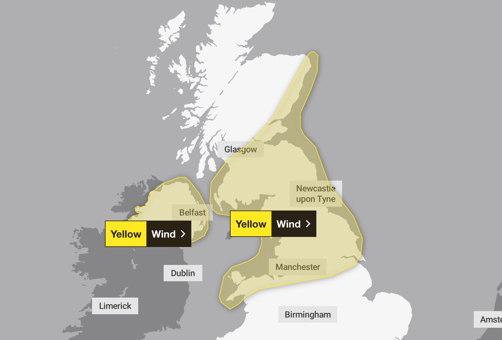
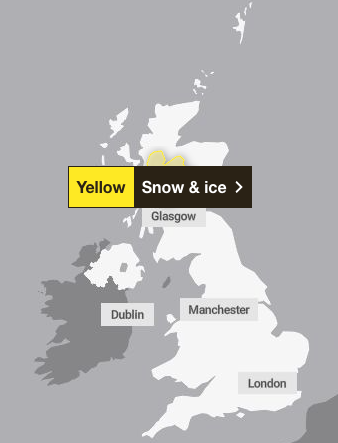
Several weather warnings are in place on Thursday and Friday, with strong winds of up to 70mph possible, and up to 10cm of snow and ice in parts of Scotland.
After a wet start to the year, the country has seen brighter weather in recent days, with the start of March bringing warmer weather. Last Thursday was the hottest day of the year so far, with sunshine bringing temperatures to 19.2C.

The highest temperature was recorded in Northolt, London, and exceeded the previous hottest day of the year, when 18.7C was recorded at Kew Gardens the week before.
It meant parts of the UK were hotter than Barcelona, with the Spanish city seeing highs of 16C.
But the coming weather is expected to be a little more drab, with rain, wind and clouds expected across the UK.
According to the Met Office’s most recent forecast, cloudy and windy weather is expected for the rest of this week before the possibility of some hill snow in the Scottish mountains.
Strong winds are expected from 5am Thursday across parts of Scotland, the north of England and the Midlands, Wales and Yorkshire until 8pm. Gusts of 50 to 55mph are widely expected, associated with an active weather front moving southeastwards across the UK, according to a yellow weather warning.
Some coastal locations and areas downwind of high ground will experience gusts of 60mph or even 70mph in a few places. Winds will ease from the north through the day.
Northern Ireland will also see southwesterly winds, expected to gust between 40 and 50mph across much of country during Thursday morning. There is potential for many areas to see a short period when gusts may reach 50 to 60mph accompanied by heavy rain. Winds will come from the west during the late morning; the warning ends around 12pm.
Blustery wintry showers will affect central and northwest Scotland during Thursday afternoon and evening but are expected to become more frequent during the second half of the night before easing on Friday morning.
A snow and ice weather warning is in place across Scotland from midnight to 9am Friday, which is expected to bring 2-5cm of snow across the Aberdeenshire and Highlands area, with 10cm possible on high ground. The forecaster warned this could lead to travel disruption and injuries from slippery surfaces and roads.
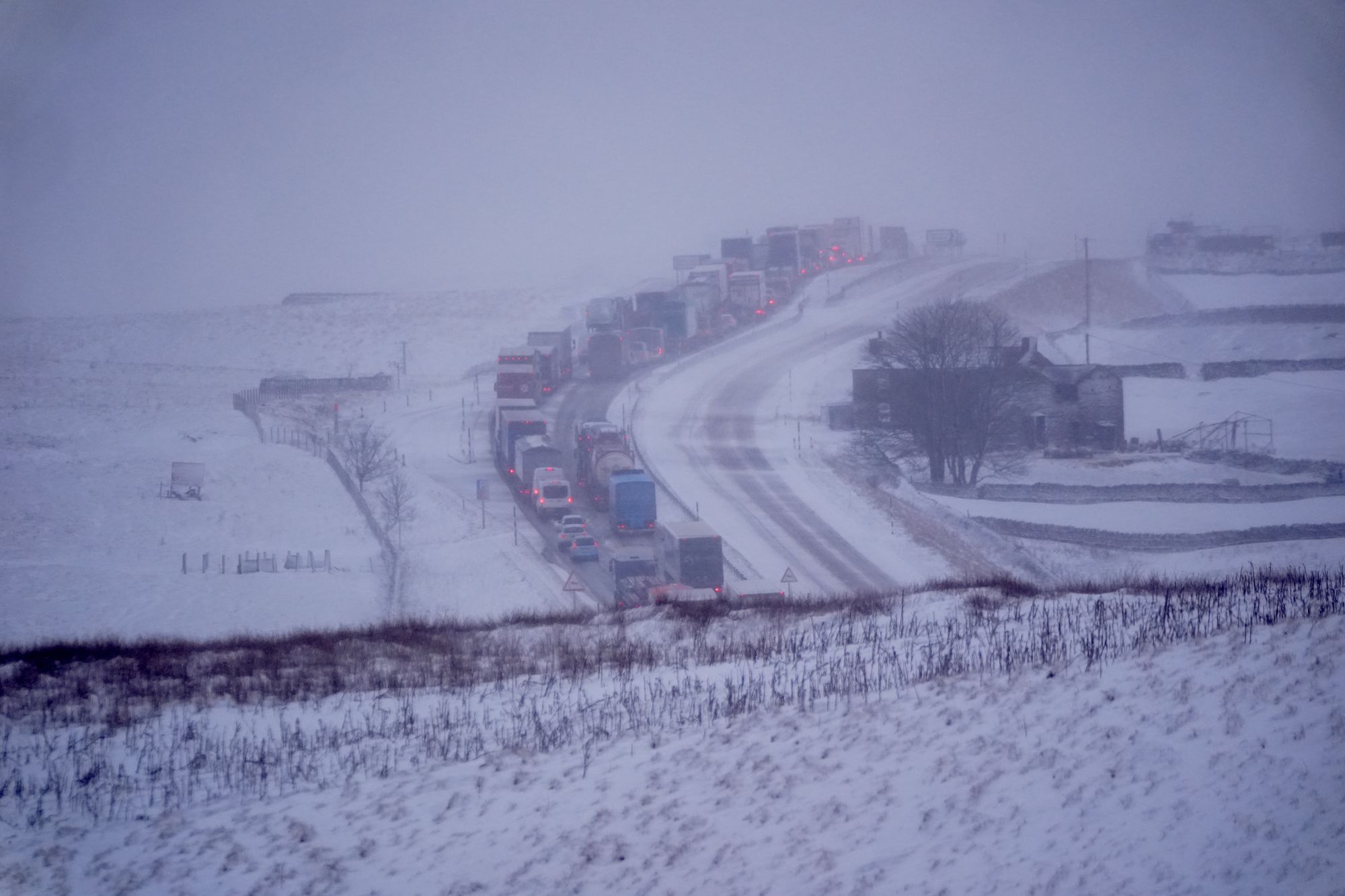
Rain and wintry conditions are forecast from Thursday onwards, with temperatures dropping on Friday from what has been felt in recent days. The forecaster remarked that temperature peaks of 7 to 9C were slightly below what Brits had experienced in the past few days and blustery winds would make that feel more like between 1-5C.
Jason Kelly, chief operational meteorologist for the Met Office, added: “A notable shift in wind direction to a northwesterly flow will bring a markedly colder day nationwide on Friday, with the potential for a mixture of sunny spells, heavy showers, coastal gales, and snow over high ground.
“There’s also the possibility of accumulations on lower hills, too. The picture will become clearer closer to the time, so keep an eye on our forecast as the week progresses.”
Latest Met Office forecast
Today:
Heavy rain sweeping southeastwards across Scotland and Northern Ireland this morning, reaching northern and western England and Wales this afternoon. Brighter, but with patchy rain to the south east. Turning brighter, showery, and colder, further North. Windy, with gales in places.
Tonight:
Heavy rain clearing southeast across England and Wales tonight. Otherwise clear spells and showers, some wintry. More persistent rain and snow in the north, where patchy frost and ice. Windy.
Friday:
A cold and windy day with a mixture of sunshine and blustery showers. Showers merging to give more persistent rain and snow in places, the snow most likely over hills.
Outlook for Saturday to Monday:
Widely frosty to start Saturday, then sunshine and scattered showers, some wintry. Lighter winds. Rain then showers on Sunday. Some hill snow. Further rain arriving in the West on Monday. Windier again.
UK aid often lacks clear priorities and often isn’t value for money, watchdog warns
Snow showers forecast in parts of Scotland after blustery conditions hit UK
Iran-US war latest: Oil prices soar again after two Iraqi tankers attacked
From energy bills to petrol: How the Iran-US war could affect UK cost of living
Lloyds and Halifax ‘technical glitch’ showing other users’ transactions to customers
Iran war hits UK housing market with sales and inquiries both down