Get all your news in one place.
100's of premium titles.
One app.
Start reading
The Economic Times
The Economic Times

Since 2012, Stanford researchers linked 2 sensor technologies to record hurricane forces near the sea surface. Now, the new data stream could help forecast storm intensity before hurricanes make landfall

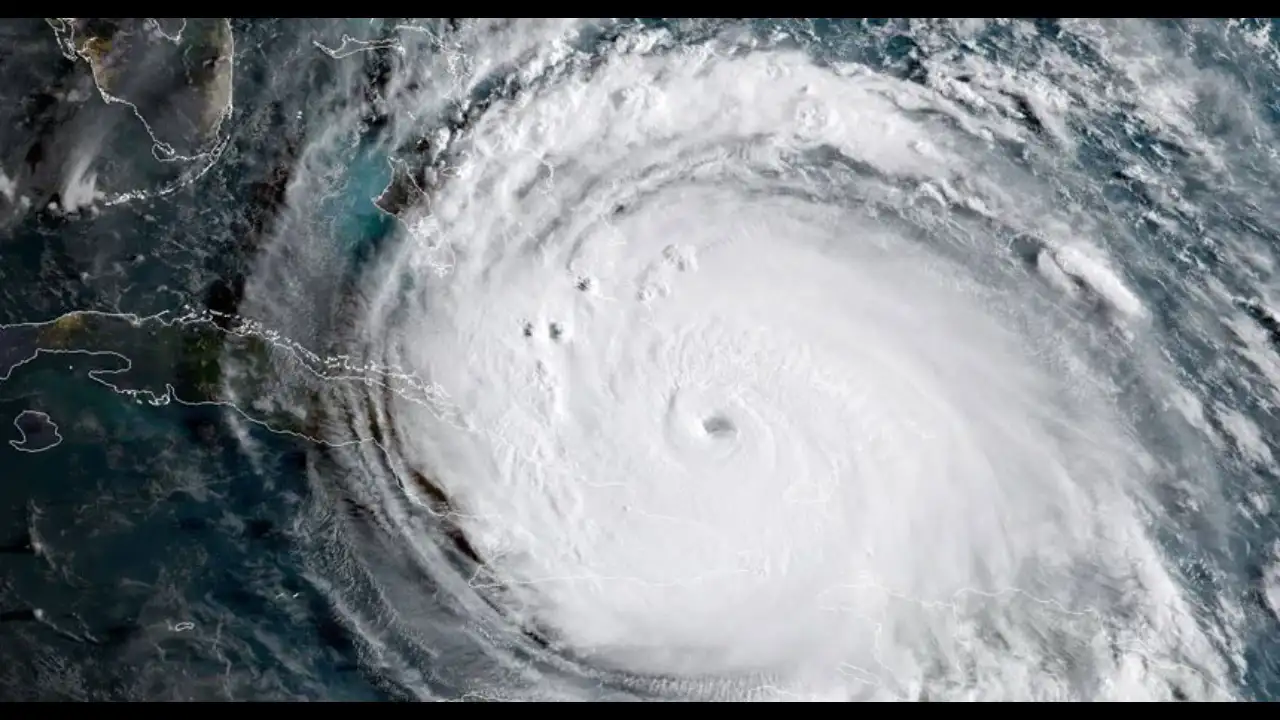
A hurricane does not need to shake a building to move the ground. In 2012, Hurricane Isaac crossed Louisiana and produced tiny movements that were recorded by instruments designed for an entirely different purpose: studying earthquakes. The signals were far too small for people to feel, but they contained information about what was happening inside the storm’s turbulent lowest layer. Now Stanford researchers say those hidden signals could become another way to study hurricane strength and behavior.

The idea is unusual because forecasters normally look upward and outward when they track a hurricane. Satellites watch the cloud structure, radar observes rainfall and storm organization, aircraft measure conditions inside the storm, and buoys and weather stations collect measurements near the surface. Stanford’s work suggests there may be another place to look: the ground beneath the storm. Existing geophysical stations could potentially provide continuous measurements without sending another aircraft into dangerous weather.
The most interesting part is not simply that earthquakes sensors can “hear” hurricanes. It is that the instruments appear to record local turbulence close to the surface , where the storm interacts with the atmosphere and where accurate measurements can be difficult to obtain. That could make old seismic data unexpectedly useful for understanding how hurricanes behave before and during landfall.

What did scientists actually record during Hurricane Isaac?

Hurricane Isaac made landfall along the Louisiana Gulf Coast in August 2012 as a Category 1 storm. At the time, seismic stations and infrasound microphones were already operating in the region as part of a National Science Foundation-funded project designed to study Earth’s interior. Louisiana is not a place where large numbers of earthquake sensors would normally be concentrated, which made the storm’s encounter with the network something of a scientific accident.

Those instruments recorded a distinctive signature as Isaac passed overhead. The seismometers detected ground displacement associated with the storm’s pressure fluctuations, while the infrasound instruments captured pressure changes in the atmosphere that humans cannot hear. The records even showed the relatively calm eye passing over some stations, surrounded by the much more turbulent eyewall. That gave researchers a rare look at how the hurricane’s near-surface conditions changed as different parts of the storm moved across the instruments.

Why would a hurricane move the ground?

The explanation is surprisingly simple. Strong turbulence inside a hurricane creates constantly changing pockets of atmospheric pressure, pushing down on the surface and then easing off again. The ground responds elastically to those changing loads, producing movements that are extremely small but detectable by sensitive seismometers. Researchers found that the signal was not simply the combined effect of a giant storm generating seismic waves across hundreds of miles. Instead, the measurements were dominated by turbulence occurring locally, within a few kilometers of each station.

That distinction matters. A measurement representing conditions immediately around a sensor can potentially tell scientists more about the hurricane’s boundary layer, the lowest part of the atmosphere where the storm’s winds interact directly with the surface. That region is important to hurricane evolution, yet it is also difficult and sometimes dangerous to measure continuously. Stanford researchers used large-eddy simulations and models of the ground’s elastic response to connect the atmospheric turbulence with the seismic observations.

What does the infrasound microphone add?

The second signal gives researchers a different piece of the puzzle. Infrasound microphones detect pressure fluctuations below the range of normal human hearing, allowing scientists to monitor changes in the atmosphere continuously. In the Stanford study, the researchers found that the infrasound measurements could serve as a proxy for wind speed around 10 meters above the surface. The pressure spectrum also provided information about turbulent energy dissipation higher in the surface layer, around 100 to 200 meters above the ground.

That does not mean a seismometer can suddenly replace a hurricane aircraft or NOAA weather station. It means the instruments may fill gaps between existing observations. Towers provide valuable measurements close to the ground, radar can offer snapshots of the boundary layer, and aircraft can sample dangerous parts of a storm directly. A network that quietly records seismic and atmospheric signals could provide another continuous layer of information alongside those systems.

Who is behind the research?

The work was led by Qing Ji, who conducted the research as a PhD student in the laboratory of Stanford geophysicist Eric Dunham. Ji collaborated with Ipshita Dey, who studied hurricane boundary-layer winds, bringing together geophysics and atmospheric science. The research was published in Science on August 6, 2026, under the title “Turbulent seismoacoustic imprints during a hurricane landfall.”

The collaboration grew from a question about what the seismic instruments were actually seeing. Earlier work had suggested that hurricane-related seismic signals might be overwhelmed by waves generated across the much larger storm system. Instead, the researchers found evidence that the seismometers were responding strongly to local turbulence. That changed the direction of the investigation and opened the door to using the same measurements for atmospheric research.

Could this improve hurricane forecasting for Americans?

Potentially, but that is still a step ahead of what the study proves. The research demonstrates that seismic and acoustic observations can reveal useful information about hurricane boundary-layer turbulence. It does not establish an operational forecasting system capable of telling communities that a hurricane is about to rapidly intensify. More storms will need to be studied to determine how reliably these signals correspond to changes in storm intensity.

For the United States, the possible value is straightforward. Hurricanes regularly threaten Gulf Coast and Atlantic communities, where even small improvements in understanding a storm’s behavior can matter for emergency planning and preparation. A sensor network that already exists for geophysical research could potentially contribute additional observations without requiring every new measurement to come from a specialized weather mission. The practical question now is whether the method works consistently across different storms, landscapes and intensities.

The next challenge is scale. Hurricane Isaac provided an unusually valuable case because the storm crossed a network carrying both seismic and atmospheric instruments. Researchers now need to test whether similar signatures appear in other hurricanes and whether the measurements can be translated into reliable estimates of wind, turbulence and storm evolution. Stanford researchers also point to broader applications for studying other atmospheric phenomena, not just hurricanes.

Sign up to read this article
Read news from 100's of titles, curated specifically for you.
Already a member? Sign in here
Related Stories
Top stories on inkl right now
One subscription that gives you access to news from hundreds of sites
Already a member? Sign in here
Our Picks
Fourteen days free
Download the app
One app. One membership.
100+ trusted global sources.