Satellites in space are watching as Hurricane Ernesto races through the Atlantic Ocean not long after it made landfall in Bermuda on Saturday (Aug. 17), where it dumped seven to nine inches (18 to 23 centimeters) of rain on the ground, downed trees and caused island-wide power outages.
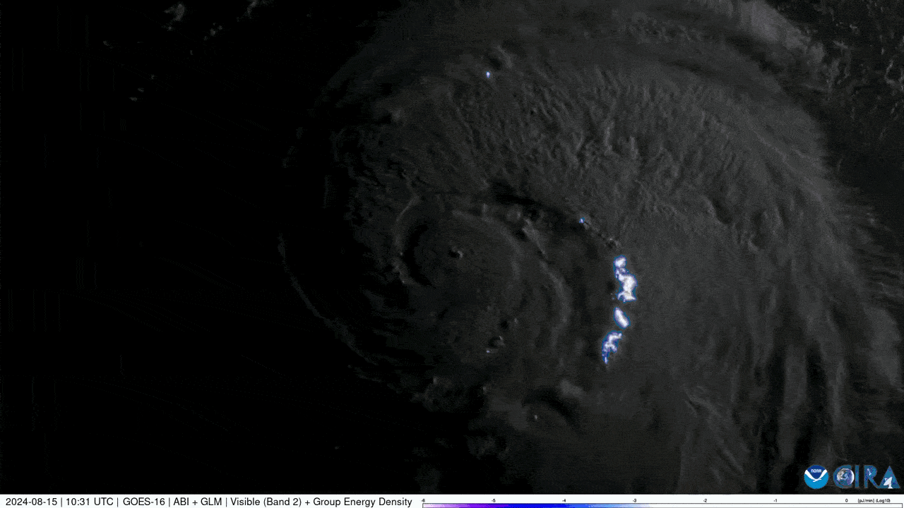
NOAA's GOES-East satellite also recorded real-time views of Ernesto last week as it watched the hurricane barrel toward Bermuda, ferrying with it heavy rainfall and dangerous 85-mile-per-hour (137-kilometer-per-hour) winds. The footage, which the satellite gathered from its vantage point about 22,236 miles (35,785 kilometers) above Earth's equator, shows lightning flashes dotting the hurricane's outer bands just a day before it made landfall in Bermuda.
The GOES-East satellite continuously monitors the entire Atlantic, providing scientists with real-time information that helps them monitor and forecast hurricanes, especially those that threaten residential areas, according to NOAA. The satellites are also able to image a storm as often as every 30 seconds, a cadence that allows scientists to discern the storm's movement and intensity.
Images collected by other NOAA satellites, taken before and after Ernesto sailed through the British island territory, show the region, along with Puerto Rico and the Virgin Islands, with the power knocked out. The aftermath was particularly extreme in Puerto Rico, where hundreds of thousands of residents were without power or water for days after Ernesto swirled past on its way to Bermuda. In the Virgin Islands, 80% of people only got back online during the weekend, NPR reported.
Related: Hurricane Debby makes landfall in Florida as satellites watch from space (video)
Convection bubbles within Tropical Storm Ernesto this morning.Ernesto is currently bringing flooding rains to Puerto Rico and the Virgin Islands. pic.twitter.com/oCDdq4dv0eAugust 14, 2024
Two NOAA satellites collectively called the Joint Polar Satellite System (JPSS), which provide data necessary for short- and long-term weather forecasts, captured Ernesto as it hovered over Bermuda on Saturday. The hurricane's eye floated over the region for over two hours before battering it with heavy rains.
Power outages occurred across Puerto Rico and the Virgin Islands as Hurricane Ernesto passed close by last week.This imagery captured from NOAA-20 and NOAA-21 compares the city lights of the islands on a normal night and after Hurricane Ernesto moved through. pic.twitter.com/nLfeHoVHXCAugust 19, 2024
Satellites monitored Ernesto even as it strengthened from a tropical storm into a hurricane last week. It is the fifth named storm and third hurricane of this year's Atlantic hurricane season, which runs from June 1 to Nov. 30. Forecasters have warned this season will be a busy one thanks to warmer-than-average ocean temperatures.
Early last month, for instance, Hurricane Beryl set the record as the strongest hurricane to attain Category 4 status after it pummeled a group of islands in the Atlantic's Caribbean Sea. And earlier this month, Hurricane Debby drenched Florida in potentially record-setting rains — more than 10 inches (25 cm).
JPSS satellites passed overhead of Hurricane Ernesto on early Saturday morning as it was centered over the island of Bermuda, where it brought heavy rainfall and large swells. pic.twitter.com/7FGjgLVEiLAugust 19, 2024
Ernesto brought tropical storm conditions to Bermuda over the weekend before continuing northeastward. Hurricane Ernesto is expected to brush Newfoundland, Canada this evening. pic.twitter.com/VWSPOjjLJGAugust 19, 2024
As Ernesto sailed away from Bermuda on Sunday (Aug. 18), it whipped 75-mile-per-hour (121-kilometer-per-hour) winds along the U.S. East Coast and Canada, the National Hurricane Center said. On Monday (Aug. 19) evening, satellites captured Ernesto heading northeast, dumping rain on Newfoundland, Canada, as it raced through the Atlantic Ocean toward the U.K.