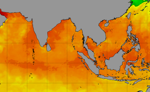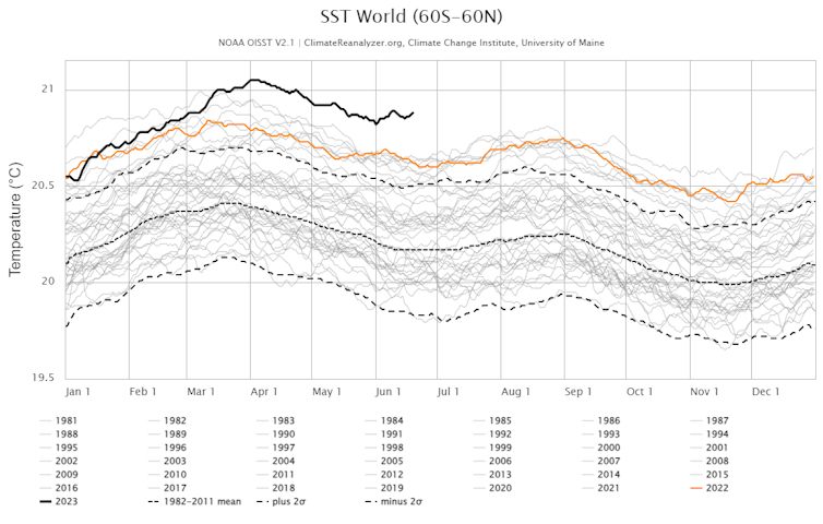
Ocean temperatures have been off the charts since mid-March 2023, with the highest average levels in 40 years of satellite monitoring, and the impact is breaking through in disruptive ways around the world.
The sea of Japan is more than 7 degrees Fahrenheit (4 degrees Celsius) warmer than average. The Indian monsoon, closely tied to conditions in the warm Indian Ocean, has been well below its expected strength.
Spain, France, England and the whole Scandinavian Peninsula are also seeing rainfall far below normal, likely connected to an extraordinary marine heat wave in the eastern North Atlantic. Sea surface temperatures there have been 1.8 to 5 F (1 to 3 C) above average from the coast of Africa all the way to Iceland.
So, what’s going on?

El Niño is partly to blame. This climate phenomenon, now developing in the equatorial Pacific Ocean, is characterized by warm waters in the central and eastern Pacific, which generally weakens the trade winds in the tropics. This weakening of those winds can affect oceans and land around the world.
But there are other forces at work on ocean temperatures.
Underlying everything is global warming – the continuing rising trend of sea surface and land temperatures for the past several decades as human activities have increased greenhouse gas concentrations in the atmosphere.
The world just came off three straight years of La Niña – El Niño’s opposite, characterized by cooler waters rising in the equatorial Pacific. La Niña has a cooling effect globally that helps keep global sea surface temperatures in check but can also mask global warming. With that cooling effect turned off, the heat is increasingly evident.
Arctic sea ice was also unusually low in May and early June, and it may play a role. Losing ice cover can increase water temperatures, because dark open water absorbs solar radiation that white ice had reflected back into space.
These influences are playing out in various ways around the world.
The effects of extraordinary Atlantic heat
In early June 2023, I visited the NORCE climate center in Bergen, Norway, for two weeks to meet with other ocean scientists. The warm waters and mild winds across the eastern North Atlantic brought a long stretch of sunny, warm weather in a month when more than 70% of days normally would have been downpours.
The whole agricultural sector of Norway is now bracing for a drought as bad as the one in 2018, when yield was 40% below normal. Our train from Bergen to Oslo had a two-hour delay because the brakes of one car overheated and the 90 F (32 C) temperatures approaching the capital were too high to allow them to cool down.
Many scientists have speculated on the causes of the eastern North Atlantic’s unusually high temperatures, and several studies are underway.
Weakened winds caused the Azores high, a semi-permanent high pressure system over the Atlantic that affects Europe’s weather, to be especially weak and brought less dust from the Sahara over the ocean during the spring, which may have increased the amount of solar radiation reaching the water. A decrease in human-produced aerosol emissions in Europe and in the United States over the past few years – which has succeeded in improving air quality – may also have reduced the cooling effect such aerosols have.
A weakened monsoon in South Asia
In the Indian Ocean, El Niño tends to cause a warming of the water in April and May that can dampen the crucial Indian monsoon.
That may be happening – the monsoon was much weaker than normal from mid-May to mid-June 2023. That can be a problem for a large part of South Asia, where most of the agriculture is still rain-fed and depends heavily on the summer monsoon.

The Indian Ocean also saw an intense, slow-moving cyclone in the Arabian Sea this year that deprived land of moisture and rainfall for weeks. Studies suggest storms can sit for longer over warmer waters, gaining strength and pulling moisture to their core, and that can deprive surrounding land masses of water, increasing the risk of droughts, wildfires and marine heat waves.
North American hurricane season up in the air
In the Atlantic, the weakening trade winds with El Niño tend to tamp down hurricane activity, but warm Atlantic temperatures can supercharge those storms. Whether the ocean heat, if it persists into fall, will override El Niño’s effects remains to be seen.
Risk of marine heat waves in South America
Marine heat waves can also have huge impacts on marine ecosystems, bleaching coral reefs and causing the death or movement of entire species. Coral-based ecosystems are nurseries for fish that provide food for 1 billion people around the world.
The reefs of the Galapagos Islands and those along the coastlines of Colombia, Panama and Ecuador are already at risk of severe bleaching and mortality from this year’s El Nino. Meanwhile, the Japan Sea and the eastern Mediterranean Sea are both losing their biodiversity to invasive species – giant jellyfish in Asia and lionfish in the Mediterranean – that can thrive in warmer waters.
These kinds of risks are increasing
Spring 2023 was exceptional, with several chaotic weather events accompanying the formation of El Niño and the exceptionally warmer temperatures in many parts of the world. At the same time, the warming of the oceans and atmosphere increase the chances for this kind of ocean warming.
To lower the risk, the world needs to reduce baseline warming by limiting excess greenhouse gas emissions, like fossil fuels, and move to a carbon-neutral planet. People will have to adapt to a warming climate in which extreme events are more likely and learn how to mitigate their impact.
Annalisa Bracco receives funding from NSF, NOAA, DOE.
This article was originally published on The Conversation. Read the original article.


