The UK is set to bask in temperatures of up to 26C today in what would be the warmest April for six years, according to Met Office forecasters.
The conditions mark an unexpected departure from the snow and severe gales of Storm Dave seen over the Easter Weekend. Much of the country is forecast to enjoy highs of between 18C to 26C, well above the early April average of 12C to 15C.
Met Office meteorologist Greg Dewhurst said the weather was “unusually warm” for the time of year, adding: “The average temperature should be around 15C.”
He said: “The wind is coming in from a southerly direction, and with not many clouds around, it should be well above the early April average.
“The last time we saw similar temperatures this time of year was in 2020, when we reached 26C in Cornwall.”
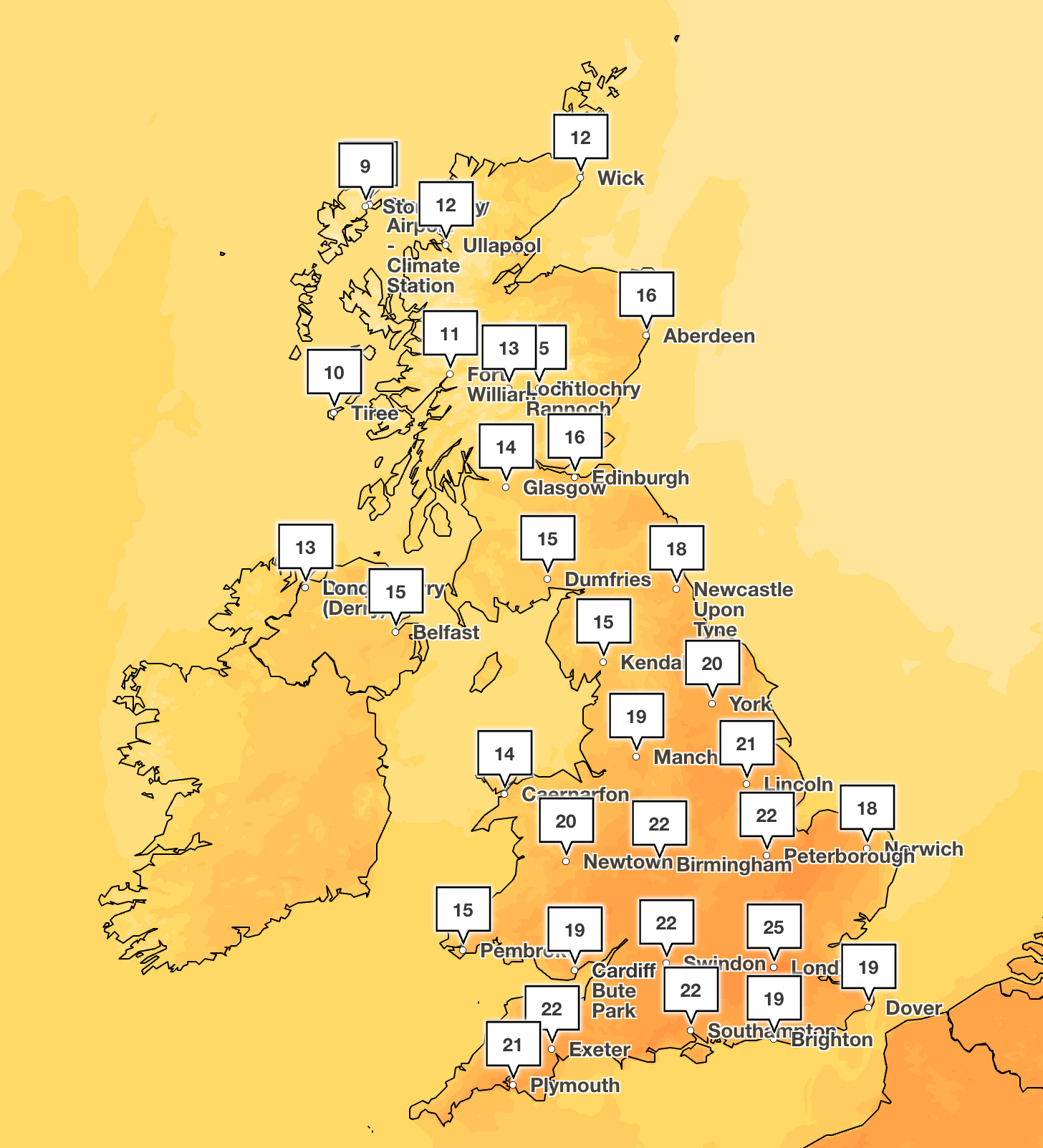
The warmest conditions will be felt in London, which is forecast to reach 25C at 5pm on Wednesday. At the same time, Swindon and Southampton will be 22C, as the southwest gets the most sunshine.
It will still be warm further north, however, with Manchester set to reach 20C and Newcastle to hit 18C.
Tuesday will be mostly dry and sunny, with windier conditions along the coasts. Some showers are anticipated into the afternoon across western parts of Wales and the northwest of Scotland.
Although Wednesday is set to be warmer than Tuesday, the Met Office warned of a “big change” on Thursday when temperatures are expected to drop to between 10C and 13C.
Temperatures are then forecast to hover around this level in the south over the weekend.
A Met Office spokesperson said: “It’s all purely down to wind direction at this time of year.
“For the next couple of days, we’re dragging in that warm, southerly wind, which will allow us to see temperatures reach the mid-20s.
“As we go into Thursday, we’ll see temperatures return to normal for the time of year as we see the weather turn more changeable with advances of rain and showers.”
Here is the Met Office’s forecast for the next five days:
Today
Often cloudy towards the north and west with some rain early on and again later in the day. Elsewhere, a fine day with plenty of sunshine and feeling very warm in places, especially across the south and east.
Tonight
A band of rain will move across Northern Ireland and Scotland overnight. Mostly dry for England and Wales with clearest skies in the east. A mild night away from northwest.
Thursday
Rain followed by cooler and showery weather will continue to move southeastwards across the UK throughout Thursday. Remaining dry and warm across the southeast until later on.
Outlook for Friday to Sunday
Unsettled throughout Friday and the weekend, with further bands of rain and showers. Some drier and brighter interludes developing in-between with temperatures near or occasionally a little below average.
London to be hotter than Barcelona as Met Office forecasts 26C temperatures
Strictly Come Dancing star to face no charges after rape arrest
Chipotle plots further UK expansion as new London venue set to open
HMS Dragon docks due to technical issue after being sent to protect air bases
Why doctors are striking this week as Streeting says NHS is ‘at risk’
The major universal credit changes coming into force this week