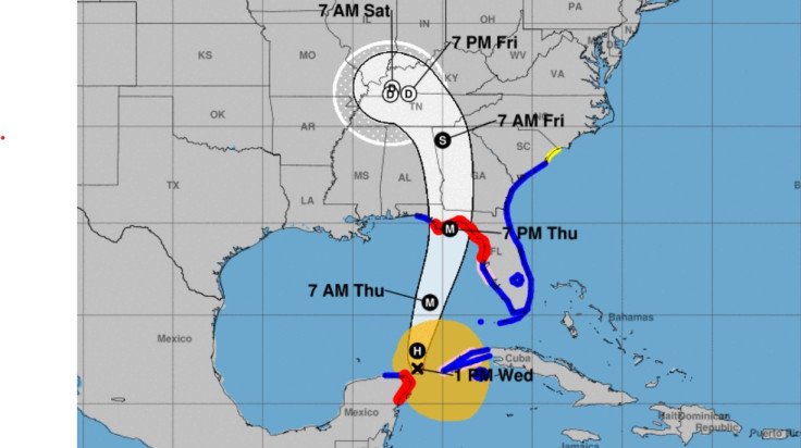
Hurricane Helene was moving into the southeastern Gulf of Mexico on Wednesday afternoon. By 1 p.m. EDT the maximum sustained winds were 80 mph with higher gusts.
The National Hurricane Center warned people along the Florida Big Bend Coast to rush to get preparations done on Wednesday ahead of life-threatening storm surge and winds.
Helene was moving north-northwest near 10 mph and a turn toward the north and north-northeast was expected later in the day and through Thursday.
It would bring the center of Helene across the eastern Gulf of Mexico and the Florida coast by Thursday evening.
Strengthening is forecast, and Helene is expected to be a major hurricane when it reaches the Florida Big Bend coast. Weakening is expected after landfall but the speed of the storm will allow strong, damaging winds well inland.
Forecasters warn that depending on tides when the storm hits, parts of the coast could have 12-18 feet of storm surge.
Hurricane-force winds extend outward up to 25 miles from the center and tropical-storm-force winds extend outward up to 275 miles.
Storm Warnings were posted across the Florida coast. A Hurricane Warning was in effect for parts of Mexico including Cozumel.
Helene is expected to produce total rain accumulations of 4 to 8 inches over western Cuba, the Cayman Islands, and the northeast Yucatan Peninsula, with isolated totals around 12 inches.
This rainfall brings a risk of considerable flooding. A 24-hour rainfall total of 8.60 inches was recently reported in Embalse Herradura, Pinar del Rio, Cuba, by the Meteorological Service of Cuba.
Over the Southeastern U.S. into the Southern Appalachians, Helene is expected to produce total rain accumulations of 5 to 10 inches with isolated totals around 15 inches. This rainfall will likely result in areas of considerable flash and urban flooding, with areas of significant river flooding. Landslides are possible in areas of steep terrain in the southern Appalachians.


