
Get all your news in one place.
100's of premium titles.
One app.
Start reading
The Conversation
The Conversation
Qiusheng Wu, Assistant Professor of Geography and Sustainability, University of Tennessee

How to use free satellite data to monitor natural disasters and environmental changes

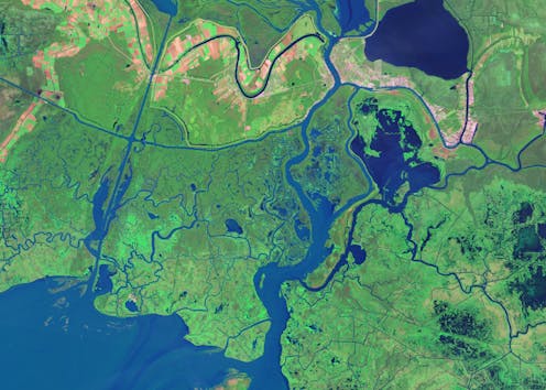
Over 8,000 satellites are orbiting Earth today, capturing images like this, of the Louisiana coast. NASA Earth Observatory

If you want to track changes in the Amazon rainforest, see the full expanse of a hurricane or figure out where people need help after a disaster, it’s much easier to do with the view from a satellite orbiting a few hundred miles above Earth.

Traditionally, access to satellite data has been limited to researchers and professionals with expertise in remote sensing and image processing. However, the increasing availability of open-access data from government satellites such as Landsat and Sentinel, and free cloud-computing resources such as Amazon Web Services, Google Earth Engine and Microsoft Planetary Computer, have made it possible for just about anyone to gain insight into environmental changes underway.

Sign up to read this article
Read news from 100's of titles, curated specifically for you.
Already a member? Sign in here
Related Stories
Top stories on inkl right now
One subscription that gives you access to news from hundreds of sites
Already a member? Sign in here
Our Picks
Fourteen days free
Download the app
One app. One membership.
100+ trusted global sources.