One of the U.S. West's worst-ever September heat waves is bringing a prolonged period of record-shattering temperatures to at least a half-dozen states this week.
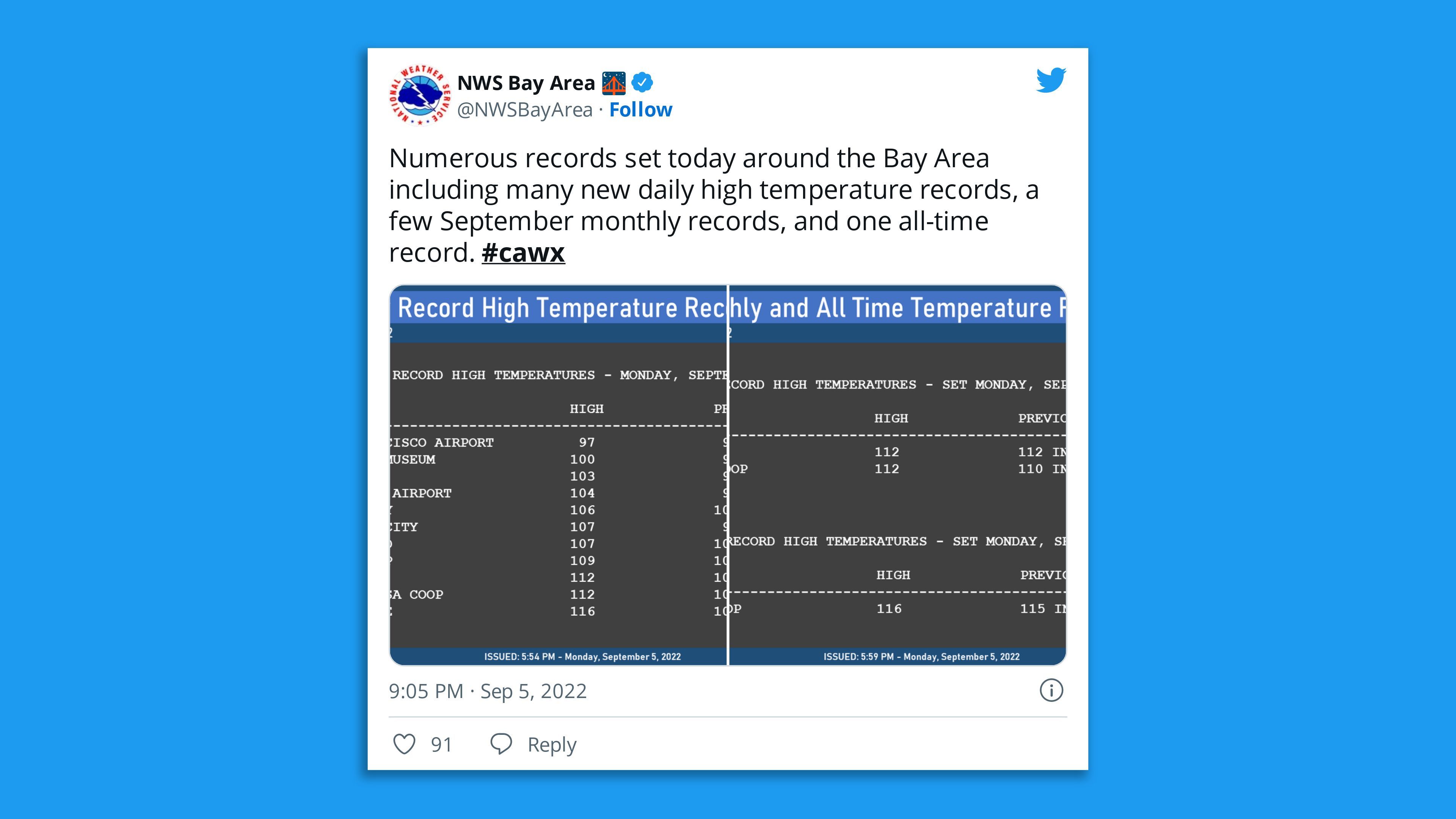
The big picture: Numerous monthly and all-time temperature records began to tumble in the San Francisco Bay Area and elsewhere in California on Monday. More records are likely to be threatened into the coming weekend.
- The heat was threatening the electricity grid, with officials warning of potential outages — particularly into Tuesday. Tens of thousands of customers were without power in the state on Monday night, notably in the San Francisco Bay Area.
- The California Independent System Operator (ISO), which runs the state's power grid, issued an Energy Emergency Alert 2 on Monday evening urging customers to conserve energy to help prevent outages.
- About 46 million people in six states were under excessive heat warnings or advisories Monday. It's likely that in many of these locations, the warnings will be extended through the end of the week.
The bottom line: "This is the worst September heat wave in Western USA history no doubt," tweeted Maximiliano Herrera, a weather historian, on Saturday night, based then on forecasts and early records.
Context: Heat waves are becoming more common, more intense and longer lasting due to human-caused global warming from the burning of fossil fuels. Some studies, in fact, have shown that extreme heat events would have been virtually impossible without the climate change component.
Threat level: The combination of the heat's severity, duration and lack of overnight temperature relief make this an extremely dangerous event from a public health perspective.
- In large parts of California, overnight lows will remain at least 20°F above average for this time of year, not falling below 80°F.
- Death Valley, California, one of the hottest locations on Earth, may tie or exceed its all-time September record of 125°F in the coming days, and could meet or beat the global record for September, which is 126°F.
- The National Weather Service forecast office in Los Angeles referred to the heat on Sunday as a "Kiln-like environment," with numerous locations away from the immediate coast surpassing 100°F.
- The Weather Service forecast office in Sacramento is forecasting "very high" heat risk through Friday, before conditions may ease some this weekend. The NWS is calling this event "record-setting, both in magnitude and duration."
By the numbers:
- 112°F: High temperature set at Ukiah Municipal Airport, California, on Sept. 5.
- 102°F: High in Great Falls, Montana, on Sept. 3, setting a monthly record.
- 104°F: High temperature in Reno, Nevada, on Sunday, a preliminary monthly record that could be surpassed in coming days.
- 103°F: High temperature in Salt Lake City on Sept. 3, a monthly record. The city may tie its record for the most consecutive 100-degree days on record, with 10.
- 115°F: Forecast high temperature in Sacramento, California, on Tuesday. This would break the city's all-time high for any month, as well as its September record.
- 94°F: Forecast high in Oakland, California, on Tuesday, which is about 20°F above average for the date.
Heat records have extended into parts of Canada, as well. And it's not just the high temperatures at the surface. Temperatures aloft, about 10,000 feet above the surface, are also setting records. This indicates the unusual intensity of this heat event.
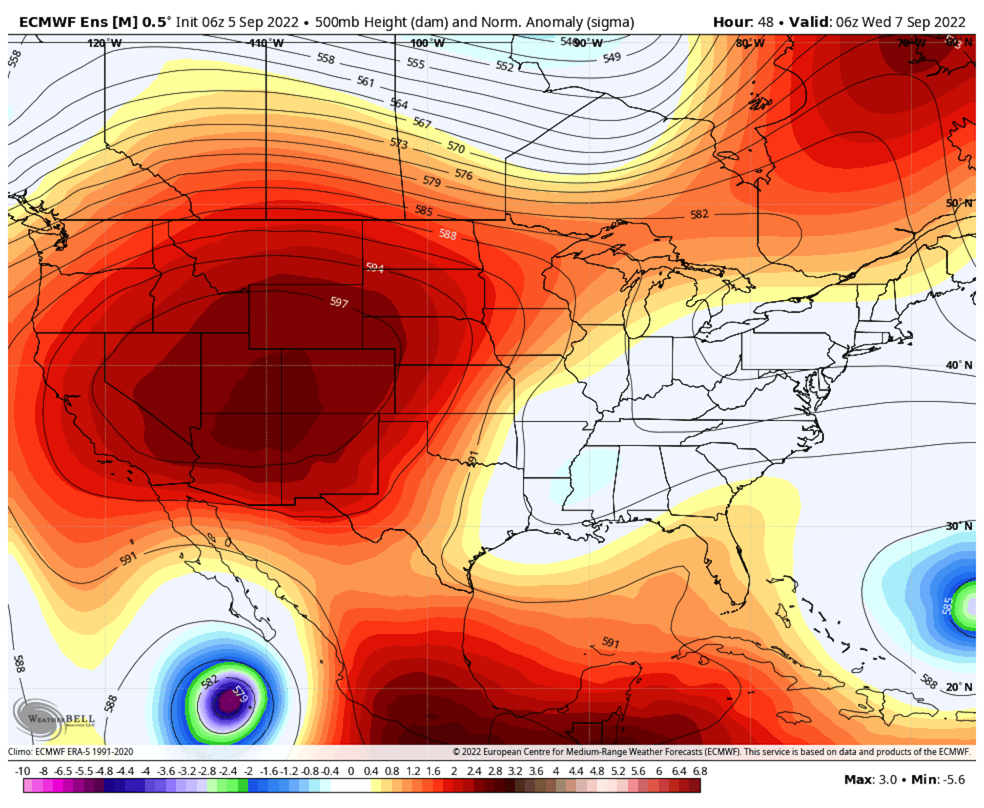
Driving the news: An expansive, intense area of high pressure, known more colloquially as a heat dome, is parked over the West. This is causing sinking air, which boosts temperatures, stifles cloud cover and squelches widespread rainfall.
Of note: Due to the looming gap between electricity supply and demand, the ISO declared a Stage 1 "Energy Emergency Alert" earlier on Monday between 4 and 10 p.m. ET before later raising the alert level to 2.
- "We are facing a load forecast of 48,817 megawatts and energy deficits between 2,000 and 4,000 megawatts for Monday," said ISO CEO Elliot Mainzer in a statement Sunday. This would result "In the highest likelihood of rotating outages we have seen so far this summer."
- This is the ISO's sixth-straight Flex Alert, and it adds an extra hour to previous days' energy demand management strategies.
- During affected hours, residents are urged to cut down on their use of air conditioning by setting higher temperatures in homes (to 78°F), and electrical appliances to help avoid rotating outages. Such alerts may be required through Friday.
What we're watching: The heat wave is raising wildfire risks, with red flag warnings in effect throughout the West and parts of the Pacific Northwest. The heat makes it more difficult for firefighters to combat any fires that ignite, given the heat-related threats to their own health.
- Firefighters are battling 53 large fires across the U.S. — including California's Fairview Fire, which killed two people as it exploded in size after igniting Monday afternoon.
Go deeper: California wildfires rage as scorching heat wave continues
Editor's note: This article has been updated with new details throughout.

