Get all your news in one place.
100's of premium titles.
One app.
Start reading
The Conversation
The Conversation
Environment
Lina Eklund, Associate Senior Lecturer, Lund University

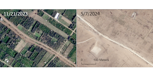
Gaza: we analysed a year of satellite images to map the scale of agricultural destruction

Part of North Gaza in November 2023, and again in July 2024. SkySat imagery © 2025/Planet Labs PBC

The ceasefire agreed between Israel and Hamas makes provisions for the passage of food and humanitarian aid into Gaza. This support is much needed given that Gaza’s agricultural system has been severely damaged over the course of the war.

Over the past 17 months we have analysed satellite images across the Gaza Strip to quantify the scale of agricultural destruction across the region. Our newly published research reveals not only the widespread extent of this destruction but also the potentially unprecedented pace at which it occurred. Our work covers the period until September 2024 but further data through to January 2025 is also available.
Sign up to read this article
Read news from 100's of titles, curated specifically for you.
Already a member? Sign in here
Related Stories
Top stories on inkl right now
One subscription that gives you access to news from hundreds of sites
Already a member? Sign in here
Our Picks
Fourteen days free
Download the app
One app. One membership.
100+ trusted global sources.