Get all your news in one place.
100's of premium titles.
One app.
Start reading
The Economic Times
The Economic Times
Piyush Shukla

A 99-year weather record just fell: Why is a rare September heat dome pushing U.S. temperatures toward 104°F? NASA maps show the unusual heat

The calendar said summer was almost over. The weather across parts of the south-central United States had other ideas. On September 15, a broad stretch of the region was dealing with intense heat, with afternoon temperatures reaching or approaching 104 degrees Fahrenheit in some areas.

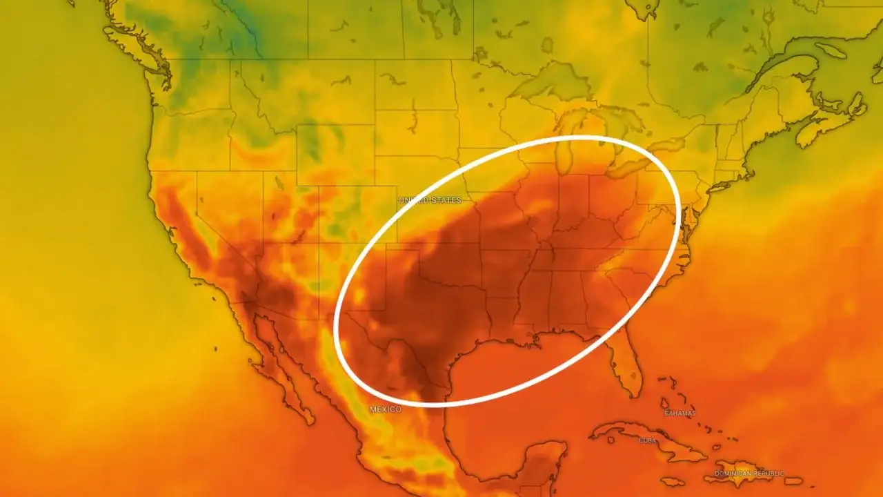
The heat was easy to see on NASA’s temperature map from that afternoon. It shows air temperatures about 6.5 feet above the ground at 4 p.m. Central Time. NASA produced the map by combining satellite observations with temperatures predicted by its GEOS model, which represents physical processes in the atmosphere.

The darkest red areas covered parts of several states. Texas, Oklahoma, Arkansas, Missouri and Tennessee were among those seeing the highest temperatures. More than 41 million people, about 12 percent of the U.S. population, were under a National Weather Service extreme heat advisory, watch or warning that day.

September 15 felt more like the middle of summer in several cities

The individual temperature records show just how far the heat had pushed conditions away from normal. Dallas reached 101 degrees Fahrenheit on September 15. Memphis reached 99 degrees, while Nashville reached 100 degrees.

Each of those readings was at least 12 degrees above normal for the date. That difference matters more than the headline number alone. A city reaching 100 degrees in the middle of summer is one thing. Reaching it in mid-September, when normal temperatures are already falling, tells a different story.

Nashville’s reading also broke a daily record that had stood since 1927. The mark had survived almost a century before the September 2026 heat finally pushed it aside. The city had already experienced an unusual night. On September 14, Nashville’s temperature did not fall below 75 degrees Fahrenheit. That set a record for the warmest minimum temperature for that date.

Nighttime heat can change the experience of a hot spell. The body needs a chance to cool after a long, hot afternoon. Buildings and roads also release some of the heat they have absorbed during the day. When temperatures stay elevated overnight, that recovery period becomes shorter.

Humidity added another problem. Meteorologists warned that the combination of moisture in the air, limited cloud cover and light winds could make conditions feel hotter than the actual thermometer reading.

The heat dome did not just bring hot air. It helped keep it there

The weather pattern behind the September heat was a heat dome. The term describes an area of high pressure in the upper atmosphere that pushes hot air downward and helps keep it near the surface.

Once that pattern settles in, several things begin working together. Sinking air warms as it moves downward. High pressure also discourages the rising motion that helps clouds and storms develop. With fewer clouds, more sunlight reaches the ground during the day. That can keep temperatures climbing.

The lack of movement in the atmosphere is part of what makes these events persistent. Light winds do not do much to move the hot air away or bring in cooler air. Convection is also suppressed, so the atmosphere has fewer opportunities to shift the heat elsewhere.

The heat arrived after an unusually warm summer across the contiguous U.S.

There was another reason the September episode stood out. It followed the warmest June-through-August period ever recorded for the contiguous United States in NOAA’s 132-year record.

NOAA reported that the June-through-August period in 2026 was 0.4 degrees Fahrenheit warmer than the previous records, set in 1936 and 2021. That figure describes conditions across the contiguous United States as a whole. It does not mean every city experienced record heat throughout the summer.

The September 15 event brought that reality into sharp focus. More than 41 million people were under extreme heat alerts. Dallas crossed 100 degrees. Nashville reached a temperature last matched by a record that had stood since 1927. And the atmosphere itself was arranged in a way that helped keep the heat in place. Summer was ending on paper. Across parts of the South, the weather had not received the message yet.

Sign up to read this article
Read news from 100's of titles, curated specifically for you.
Already a member? Sign in here
Related Stories
Top stories on inkl right now
One subscription that gives you access to news from hundreds of sites
Already a member? Sign in here
Our Picks
Fourteen days free
Download the app
One app. One membership.
100+ trusted global sources.