Get all your news in one place.
100's of premium titles.
One app.
Start reading
The Conversation
The Conversation
Environment
Chad Hecht, Research and Operations Meteorologist, Center for Western Weather and Water Extremes, University of California, San Diego

When an atmospheric river meets a bomb cyclone, it’s like a fire hose flailing out of control along the West Coast

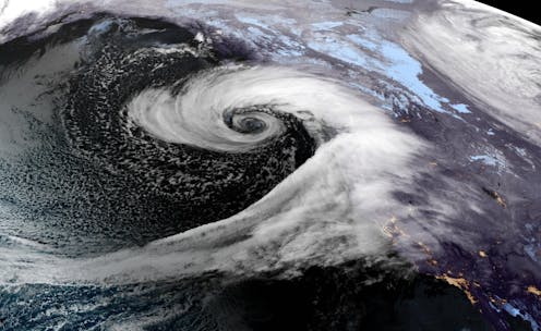
A satellite image shows an atmospheric river feeding into a bomb cyclone off the U.S. West Coast on Nov. 19, 2024. NOAA GOES

The West Coast’s rainy season has arrived in force, with an atmospheric river joining a bomb cyclone off the Pacific Northwest coast. Heavy, wet snow began falling in the mountains on Nov. 19, 2024, and rain has been blasting Oregon and Northern California, creating a risk of flooding and landslides in some areas. The atmospheric river was forecast to last for several days, hitting up and down the West Coast. Parts of Washington have seen more than 70 mph winds from the bomb cyclone.

When these two phenomena get together, the weather gets hard to predict, as meteorologist Chad Hecht of the Center for Western Weather and Water Extremes at the University of California, San Diego explains.
Sign up to read this article
Read news from 100's of titles, curated specifically for you.
Already a member? Sign in here
Related Stories
Top stories on inkl right now
One subscription that gives you access to news from hundreds of sites
Already a member? Sign in here
Our Picks
Fourteen days free
Download the app
One app. One membership.
100+ trusted global sources.