Eerily warm ocean temperatures could extend tropical trouble beyond the traditional Atlantic hurricane season.
Weather forecasters said Monday afternoon that there could be impacts into the early days of December - well past the typical November 30 end of hurricane season. The official Atlantic hurricane season ends on the last day of November.
“We may even see a tropical storm in December this year. It doesn’t happen very often, but the very warm sea surface temperatures could make it possible this year,” AccuWeather Lead Hurricane Expert Alex DaSilva said in a release.
There is little risk of direct hits in November to the western Gulf of Mexico and along the coasts of Texas, Louisiana, Mississippi and Alamba, the forecaster said.
Any late-season action the US might see would be in still-battered Florida and along the East Coast.
“The entire state of Florida up into the Carolinas could be at risk of experiencing another tropical impact this season. This region is already vulnerable after dealing with multiple landfalls earlier this year,” DaSilva warned. “The western and central Gulf of Mexico coastline likely will not see any direct impacts for the rest of this hurricane season.”
A late-season surge is expected in November, with up to three additional named storms possible in the Atlantic basin, forecasters predicted. Patty the next on the list for named storms.
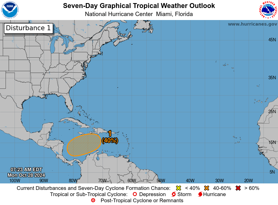
The National Hurricane Center says an area of low pressure is likely to form over the Caribbean in a few days, with a tropical depression potentially forming late this week or over the weekend. However, the system currently poses no threat to the continental US.
These conditions are fueled by climate change, which has made hot ocean temperatures in the Caribbean and Tropical Atlantic at least 800-to-900 times more likely, according to non-profit Climate Central.

In the Caribbean, where the hurricane center is monitoring potential storms, ocean temperatures have been made at least 600-to-800 times more likely due to climate change.
Temperatures are starting to rebound, according to AccuWeather Senior Meteorologist and Climate Expert Brett Anderson. But the trend of storms forming outside of the official Atlantic hurricane season is expected to continue, potentially with impacts to holiday beach vacations. Notably, Florida is America’s top destination for domestic tourism. Travelers spent a record $124.9 billion in the state in 2022.
“The presence of this widespread and record-high ocean heat content this year means basins such as the western Caribbean will likely remain abnormally warm well into next year and possibly well beyond that,” he said.
“In addition to providing extra heat energy to fuel rapid intensification of tropical storms and hurricanes, those warm waters may also lengthen the hurricane season beyond what has been typically the norm over the past century. An earlier start and a later end to the hurricane season may very well be what our near future holds.”


