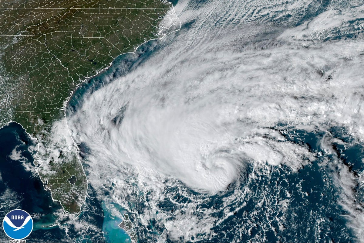
Tropical Storm Nicole is on track to make landfall in Florida overnight on Wednesday into Thursday after strengthening into a Category 1 hurricane.
The storm will likely hit land somewhere in southeast Florida between Boca Raton and Palm Bay, putting former president Donald Trump’s Mar-a-Lago estate in the potential cone of impact.
Nicole will bring heavy winds and rain to Florida, bringing a rare late-in-the-season hurricane to the Sunshine State just weeks after Ian devastated communities around Fort Myers and Naples.
The Florida Division of Emergency Management has urged residents in the storm’s path to monitor weather reports and have a “disaster supply kit” at hand.
The National Hurricane Center (NHC) is forecasting a storm surge of up to five feet (1.5 metres) along part of Florida’s Atlantic coast, with up to 8 inches (20 centimetres) of rain in some locations. As a result, some flash flooding, especially in low-lying areas and areas with poor drainage, like cities.
In West Palm Beach, some early flooding along the coast has been reported as the storm moves in toward land.
By Wednesday morning, Nicole’s centre was just off the coast of the northern Bahamas, and the storm was forecast to become a Category 1 hurricane by the afternoon before hitting Florida.
A hurricane warning has been issued for part of the northern Bahamas, and Florida’s east coast from Boca Raton through Volusia County. Other coastal areas, including far southeast Florida, northern Florida, Lake Okeechobee, Georgia and parts of South Carolina, are under a tropical storm warning.
A storm surge warning, meaning “danger of life-threatening inundation”, has been issued from West Palm Beach through part of the Georgia coastline, and on part of Florida’s Gulf Coast from Pinellas County to St James Island, according to NHC.
More than 39 million people are under inland flooding alerts, and more than 27 million people are under coastal flooding alerts as of Wednesday morning.
The Orlando International Airport has said that it will cease operations starting on Wednesday afternoon as they prepared for the storm’s impact.
Parts of Flagler, Volusia, Palm Beach and Nassau counties in Florida were under mandatory evacuation orders, with officials urging residents in low-lying areas and mobile homes to seek shelter. Other counties along the Atlantic Coast had voluntary evacuation orders in place.
While the communities hit most directly by Hurricane Ian likely won’t receive the brunt of Nicole’s impact, they could get significant rain and heavy winds over the next two days, even as many communities are still reeling from the storm that left more than 100 people dead earlier this year.
But the storm’s impact will likely spread much further out of Florida over the rest of the week. While Nicole is forecast to weaken back into a tropical storm by Thursday morning, it is projected to turn to the northeast later that day and move up the Atlantic Coast.
The southeast and Appalachia could see between two to four inches (5-10 cm) of rain over the next few days, with some spots seeing up to six in (15 cm), NHC warns. The storm will stretch as far north as New York and New England, bringing up to four in (10 cm) of rain to parts of the region.
Much of the eastern US could see some localized flash flooding because of the heavy rainfall.
If it reaches Category 1 status, Nicole would be one of the rare November hurricanes to reach land. The last hurricane to hit Florida in November was Hurricane Kate in 1985.
According to the National Oceanic and Atmospheric Administration (NOAA), the average year features less than one named storm forming in November. This year has already featured two additional November hurricanes, Lisa and Martin, both Category 1. Lisa made landfall in Belize while Martin did not pose a threat to land.
While NOAA had predicted an “above-normal” hurricane season, the year is likely to hit the lower range of what was expected after a particularly quiet summer. Hurricane season in the Atlantic lasts from June through the end of November, peaking in early September.
But the two major hurricanes that did form were particularly destructive. In September, Hurricane Fiona slammed into Puerto Rico and left much of the island out of power for weeks.
Later that month, Hurricane Ian hit southwest Florida as a near-Category 5 storm and one of the most destructive and deadly hurricanes in recent US history.
And hurricanes are expected to get even stronger on average as the climate crisis grows over the next few decades. A hotter planet means warmer ocean surface temperatures — which can help quickly power up a storm to dangerous strength, much like what happened with Hurricane Ian.
A UN climate science panel has found that over the past four decades, the percentage of storms reaching Category 3 or higher has been increasing.


