After this spring’s heat, humidity, rain and storms across Australia, you may be wondering what summer has in store.
The Bureau of Meteorology’s long-range summer forecast, released today, gives some indication of how the coming months are likely to unfold. Notwithstanding the challenges of making these forecasts, seasonal prediction can be very valuable for climate-sensitive industries such as agriculture, as well as being of great public interest.
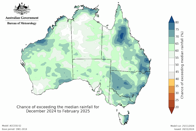
The latest outlook from the bureau suggests we’re in for more of the unsettled weather we’ve been experiencing during spring. On average, hotter night-time temperatures and higher rainfall are expected over summer.
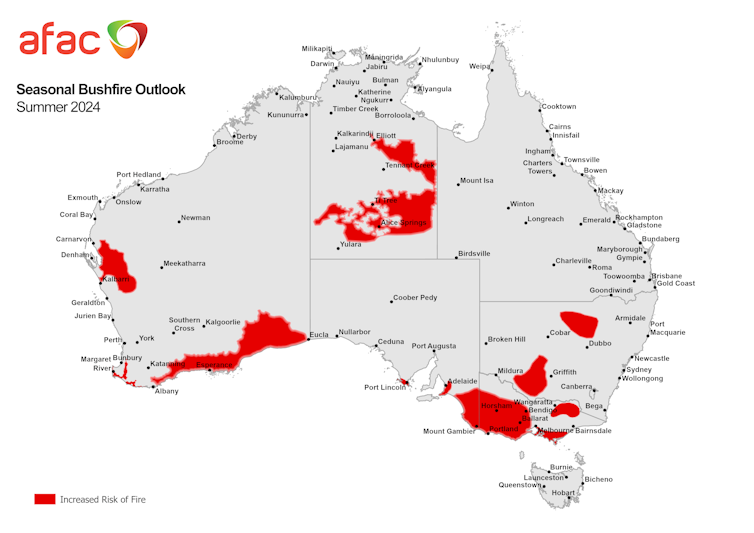
Meanwhile, this summer’s seasonal bushfire outlook shows an increased risk of fire across large parts of Australia, such as southeastern South Australia and western Victoria, central Australia around Alice Springs, and southern stretches of Western Australia.
Unseasonal November weather in the southeast
This spring has been a mixed bag, with wetter than normal conditions through much of northwestern Australia, as well as swings between hot and dry weather and cooler, wetter conditions elsewhere.
There were several severe weather events, starting with record-breaking heat across the north and floods in Tasmania.
In recent days, eastern Australia experienced severe storms with unusually high humidity in states such as Victoria.
So what can we expect over the next three months? That’s a simple question with a not-so-easy answer.
How reliable are long-range forecasts?
Long-range seasonal forecasting is challenging, as the science is still developing rapidly. In contrast, short-term weather forecasting has been around much longer.
For daily weather forecasts, the skill lies in knowing the recent weather conditions very well. Having more observations of properties such as temperature, wind and rainfall helps to improve these forecasts. This information is then fed into weather models, which in most places are accurate for seven to ten days.
How can meteorologists predict chaotic weather systems further in advance? They rely on the fact that while the climate is variable, it is possible to predict this variability by looking at larger-scale drivers.
In Australia, our climate is strongly influenced by drivers of variability such as the El Niño-Southern Oscillation, which have some predictability. This lends some accuracy to seasonal outlooks.
These climate drivers have their own seasonal cycles. This means there are times in the year when seasonal outlooks are more accurate than others. El Niño and the Indian Ocean Dipole both have strong relationships with Australia’s climate in spring. As a result, spring outlooks tend to be more accurate than predictions for other seasons.
Over summer, more of our rainfall comes from thunderstorms. That means rainfall is more variable between places even just a few kilometres apart and also less predictable. Overall, this makes seasonal predictions for summer much harder.
How’s summer shaping up?
While it is harder to forecast summer, we can watch the climate drivers to gauge what’s likely to happen.
When the El Niño–Southern Oscillation is in an El Niño phase, the climate tends to be hotter and drier. In a La Niña, the climate tends to be cooler and wetter. But it can also be in betweeen, or “neutral”, as it has been since April. It looks likely to stay neutral over summer, though there’s a chance it might develop into a weak La Niña event.
In summer, the Indian Ocean Dipole, which can bring rain to southeastern Australia in its negative phase, tends to weaken and have less influence on Australia’s climate.
Locally, the seas around Australia remain warmer than normal, which increases evaporation and makes more moisture available for rainfall.

Taken together, this is why the outlook is pointing towards wetter-than-normal conditions for much of Australia over summer. But we can’t be sure because when the ENSO climate driver is in the neutral phase, the effect on our weather is weaker.
In many places, there’s a roughly 2-in-3 chance of a wetter than average summer. But that means there is still a 1-in-3 chance of a drier than normal summer.
Accompanying the wetter summer outlook is a prediction for warmer nights and, to a lesser extent, warmer days. Night-time temperatures tend to be higher when there is cloud and rain.
Most seasonal outlooks point to warmer than average conditions these days. That’s partly because we’re comparing the coming season to the average of all the summers from 1981–2018. It was cooler then.
Remember, Australia’s climate has already warmed by 1.5°C since 1900.
A summer of fire for some?
The National Council for Fire and Emergency Services draws on the bureau’s long-range summer forecast to develop its own seasonal outlook of bushfire risk, which was also released today.
Such seasonal bushfire outlooks are also challenging to make. Complex combinations of weather and fuel (dry vegetation) characteristics shape whether a fire is likely to occur and spread if there is an ignition source (such as lightning). But these outlooks are important when planning for managing one of Australia’s major hazards. They are also useful in raising public awareness of fire risks as the southern Australia fire season gets under way.
Areas most at risk include Western Australia’s southeastern coastline, South Australia’s lower Eyre Peninsula around Port Lincoln, and the lower southeast including Mount Gambier, stretching over the border into southwestern Victoria around Horsham.
Parts of northeast Victoria and the Mornington Peninsula near Melbourne are also at higher risk, as well as northern and central southern New South Wales.
In northern Australia, the areas most at risk include long-unburnt areas in the southern half of the Northern Territory through to north of the Barkly Highway and across to the Queensland border.
Some of these areas are also regions where rainfall has been below normal in recent weeks and months. The continuing stormy conditions and potential for heavy rain over parts of Australia will hopefully reduce the risk of fires in these areas.

Be prepared
In any summer, parts of Australia will experience periods of extreme heat, risk of fires, and stormy weather that can bring hail and flooding rains. Being prepared for severe weather, keeping an eye on the forecast and following any weather warnings that are issued is important to minimise your risk.
Andrew King receives funding from the ARC Centre of Excellence for 21st Century Weather and the National Environmental Science Program.
This article was originally published on The Conversation. Read the original article.


