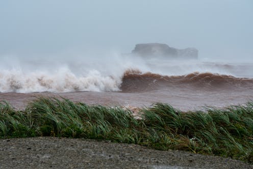
Post-tropical storm Fiona caused a lot of damage and erosion on the coasts of Nova Scotia, Prince Edward Island and the Magdalen Islands.
But did you know that the effects of the storm were also felt in the waters of the Gulf of St. Lawrence at a depth of more than 50 metres?
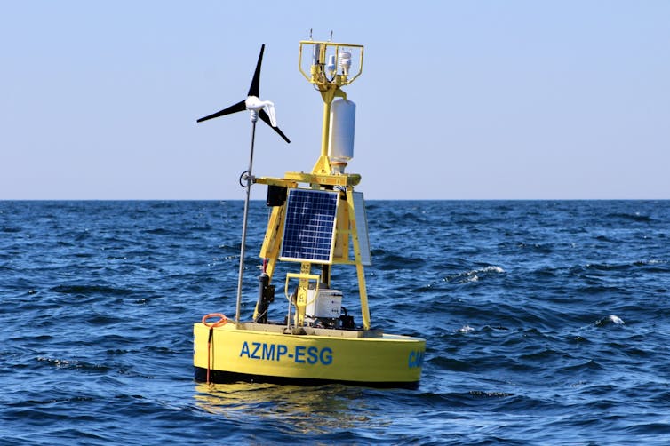
After making landfall on Cape Breton Island with strong winds, the centre of the cyclone swerved back over water into the Gulf of St. Lawrence, where it passed close to two oceanographic buoys operated by Fisheries and Oceans Canada. These buoys are equipped with sensors that measure wind speed and direction, atmospheric pressure, air temperature and humidity, similar to a land-based weather station. They also include sensors that measure the temperature and salinity of the water surface, as well as wave height, and can be equipped with a probe that is descended to the bottom of the water to measure the temperature and salinity over the entire depth.
These buoys transmit their measurements to us every 30 minutes through the cellular network or by satellite communication, even during an intense storm like Fiona.

This article is part of our series, The St. Lawrence River: In depth. Don’t miss new articles on this mythical river of remarkable beauty. Our experts look at its fauna, flora and history, and the issues it faces. This series is brought to you by La Conversation.
As a research scientist in physical oceanography with Fisheries and Oceans Canada at the Maurice Lamontagne Institute, I am one of the people in charge of these buoys and a user of their data. I propose shedding some light on the effects of storms on the waters of the Gulf of St. Lawrence as observed by these oceanographic buoys.
Buoys with a valuable role
The first buoy in the storm’s path was the AZMP-ESG, for “Atlantic Zone Monitoring Program East Southern Gulf,” which is located between Prince Edward Island and the Magdalen Islands. When the centre of the cyclone passed near the buoy at 11:30 UTC on Sept. 24, 2022, the atmospheric pressure briefly reached a low of 949 millibars (the unit of measurement for pressure). It had been 1,000 millibars the day before, already below the normal pressure of 1,010 millibars.

The atmospheric low of a cyclone is the lowest atmospheric pressure located in its centre. In the Northern Hemisphere, the winds rotate counterclockwise around the centre due to the rotation of the Earth.
Measuring an air pressure low at a buoy does more than tell us that the centre of the storm has passed at its closest from the buoy. Atmospheric pressure represents the weight of the atmosphere above the measuring instrument. A difference of only one millibar represents the pressure exerted by one centimetre of water height. When the atmospheric pressure at buoy AZMP-ESG dropped by 51 millibars, the pressure in the entire water column would drop by the same amount without any adjustment from the ocean.
The low pressure in the water creates a movement of water towards it to rebalance the ocean pressure. This balancing movement can make the water surface rise up to 51 cm! Adjustments of the sea in the face of low atmospheric pressure are responsible for much of the sea level surges associated with the storm surges that flood coastal lands. A surge is the excess of sea level compared to the tidal forecast.

Record waves and falling temperatures
The maximum wave height measured at AZMP-ESG reached 9.9 m during the storm and gusts reached 126 km/h. It should be noted that waves very rarely exceed a height of three metres in the Gulf.
A few hours later, at 8:30 p.m., the atmospheric pressure reached 953.9 millibars at buoy IML-10 located northeast of the Magdalen Islands. Gusts reached 124 km/h and waves reached a record of 15.9 on our buoy network, surpassing the previous record of 13.1 m measured at the same location in September 2019, during post-tropical storm Dorian.
These dramatic effects are not the only ones on the ocean, however. At buoy AZMP-ESG, sea surface temperature dropped by 6.5°C during the passage of Fiona, then 16.4°C on Sept. 23 and 9.9°C on Sept. 25. Normally, the surface water temperature of the Gulf decreases by about 1°C per week in the fall, as a mixed layer of water forms that eventually encompasses nearly half the volume of all Gulf waters in the winter.
The 6.5°C cooling in two days is therefore the equivalent of more than six weeks of seasonal change. But more importantly, it is offset by an unusual warming at depth due to a redistribution of heat there by vertical mixing caused by wind and waves.
The impacts at depth
Consider the better documented example of post-tropical storm Dorian in September 2019, when the surface temperature dropped 7°C as it passed buoy AZMP-ESG.
A temperature profile made with the probe lowered from a winch on the buoy prior to the storm shows a highly stratified water column (i.e. less dense seawater floating on top of denser water) with a temperature of 21°C at the surface and 1.5°C at 35 m depth. At a depth of 35 m, the water is usually very cold.
In nearly 200 profiles created by the buoy between June and August, the average temperature at this depth was 1.1°C with little variation. It is therefore usually a depth where temperatures remain cold, constituting a thermal habitat favourable to snow crab.
The profile of Sept. 10, two days after the storm, indicates 12°C at the surface (colder than before the storm) and 8.6°C at 35 m (warmer). Thus, the cooling at the surface was offset by an equivalent warming at 35 m and the average temperature over the first 45 m is nearly identical between the two profiles, indicating a redistribution of heat to the depths.
In the usually stable and cold thermal habitat at a depth of 35 m, a jump in temperature to 8.6°C is therefore a significant thermal shock that can last for several weeks, as the mixed layer has a high thermal inertia and will retain its temperature. After several weeks, the air temperature drops below the water temperature and the cooling and thickening of the mixed layer continues until the end of winter.
Without in any way minimizing the devastating effects that storms like Fiona and Dorian have on coastal communities, they also have significant effects deep in the ocean.
Even the snow crab on the bottom feel the effects!
Peter Galbraith heads the Atlantic Zone Monitoring Program of Fisheries and Oceans Canada, so this program is funded by that department. The buoy system is operated by Fisheries and Oceans Canada.
This article was originally published on The Conversation. Read the original article.


