Storm Goretti has hit the UK with 99mph winds and heavy snow as part of a “weather bomb”, with yellow and amber weather warnings to continue throughout Friday.
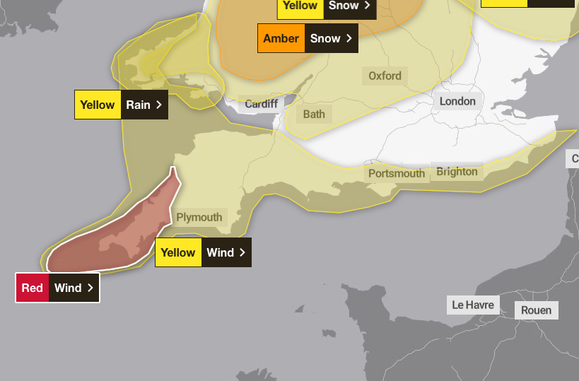
The Met Office updated an amber wind warning for Cornwall and the Isles of Scilly to red between 4pm and 11pm on Thursday, with “dangerous stormy winds” battering the south west of England.
Winds of 99mph have been recorded at St Mary’s Airport on the Isles of Scilly, which is a new record for the site, the forecaster said, while thousands of homes around the country have lost power.
At around 9pm, more than 47,000 properties were without power in south west England, while Cornwall Council said it had reports that trees and power lines had fallen.
The government has also sent two messages via its emergency alerts system to people in affected areas, with the latest sent to people in Cornwall at 5pm.
Another six yellow weather warnings remain in place as Met Office chief forecaster Neil Armstrong has described Storm Goretti as a "multi-hazard event" with heavy rain, strong winds and snow.
Key points
- Thousands of homes without power
- Schools in affected areas to close on Friday
- Met Office issues rare red weather warning for wind
- Emergency alert sent by government
- Storm Goretti map: Where Britain will be hit by heavy snow and rare red weather warning for wind
Birmingham Airport suspends use of runway
04:15 , Namita SinghBirmingham airport has suspended the use of its runway after heavy snow.
Issuing an alert on X, the airport said: “Passengers due to travel should contact their airline regarding the status of flights.
“The safety of our colleagues and customers is our number one priority and this decision has been made with this in mind. We apologise for any inconvenience this may cause.”
Due to heavy snow runway operations have been suspended.
— Birmingham Airport (@bhx_official) January 8, 2026
Passengers due to travel should contact their airline regarding the status of flights.
The safety of our colleagues and customers is our number one priority and this decision has been made with this in mind. We… pic.twitter.com/N2br7jJbg3
Yellow warning remains in place in Scotland after red alert lifts
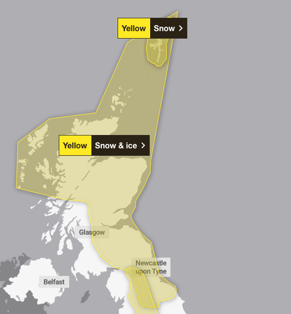
04:00 , Namita SinghA yellow warning for snow and ice is also in force across much of Scotland, where more than 250 schools are due to remain closed on Friday, including more than 150 in Aberdeenshire, dozens in the Highlands and Aberdeen, and a number in Moray.
The red warning, which was in place until 11pm on Thursday, warned of damage to buildings and homes, very large waves, flying debris resulting in danger to life, power cuts and public transport cancellations.
The Met Office's website says amber weather warnings are issued when there is an increased likelihood of impacts from severe weather, including the possibility of travel delays, road and rail closures, power cuts and the potential risk to life and property.
Yellow warnings are issued for a range of weather situations, including when it is likely that the weather will cause some low level impacts, including some disruption to travel in a few places, or when the weather could bring much more severe impacts to the majority of people but the certainty of those impacts occurring is much lower, according to the Met Office.
Storm Goretti, a ‘multi-hazard event’
03:45 , Namita SinghStorm Goretti, named by French weather forecaster Meteo France, has been described as a "multi-hazard event" by the Met Office, with as much as 30cm of snow possible in parts of the UK.
Weather warnings have been issued for snow, wind, rain and ice across the country, ahead of likely "disruption and dangerous travelling conditions".

Met Office chief forecaster Neil Armstrong said: "Storm Goretti will be a multi-hazard event, with the most significant impacts from snow in parts of Wales and the Midlands and the very strong winds in the far South West, though heavy rain in some parts of Wales and East Anglia also has the potential to bring disruption to many."
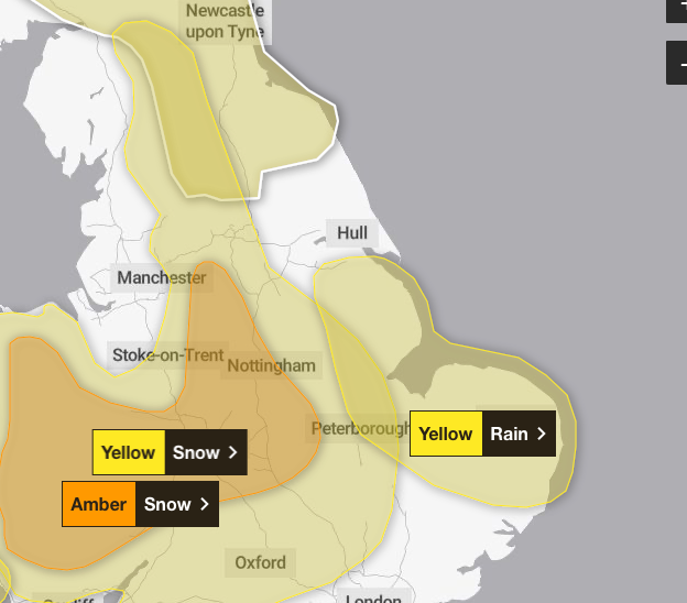
A yellow warning for wind has been issued for the rest of the south coast and Wales, where gusts of up to 70mph are forecast, while a yellow warning for snow covers swathes of England from Bath to Northumberland.
Meanwhile, an amber warning for snow runs until 9am on Friday covering parts of Wales, the Midlands and Yorkshire.
About 10 to 15cm of snow is likely across the warning area, with up to 30cm on higher ground in Wales and the Peak District.
Snow set to cause school closures, power cuts and travel disruption
03:30 , Namita SinghWintry weather is set to cause chaos across the country including school closures, widespread power cuts and major disruption to travel.
It comes after Storm Goretti brought 99mph winds while a rare red warning was issued by the Met Office for "dangerous, stormy" winds in the South West.
More than 50,000 properties were without power in the South West on Thursday evening, according to the National Grid's website, while about 9,000 had no power in the West Midlands and 2,000 were without power in Wales.
Trains were cancelled in Cornwall, and Birmingham Airport said it was suspending operations as of 9pm on Thursday because of heavy snow on its runway.
All trains in Cornwall were to be suspended from 6pm on Thursday, Network Rail said.
In Devon, trains on the Exeter-Okehampton and Exeter-Barnstaple routes were suspended from the same time because of forecast high-wind speeds.
Rail services across England, Wales and Scotland may be affected until the end of the day on Friday due to the weather, National Rail said.
A yellow warning for snow and ice is also in force across much of Scotland, where more than 250 schools are due to remain closed on Friday, including more than 150 in Aberdeenshire, dozens in the Highlands and Aberdeen, and a number in Moray.
Recap: Storm Goretti leaves 44,000 homes without power as ‘weather bomb’ hits the UK
03:15 , Dan HaygarthStorm Goretti brought a potentially deadly mix of violent winds, ice and heavy snow and rains on Thursday, forcing schools to close and leaving thousands of homes without power.
Gusts of up to 99mph were recorded as authorities issued a rare red warning – the highest level – of winds for the Isles of Scilly and Cornwall.
Emergency alerts were sent to mobile phones in the area so they sounded an alarm even if set to silent.
Trees and power lines felled in Cornwall
03:00 , Dan HaygarthCornwall Council said it had received reports of trees and power lines felled by the storm.
The Met Office said “violent gusts” will hit parts of Cornwall and the Isles of Scilly over the next few hours bringing a potential danger to life when it issued its red weather warning covering those areas.
Winds of 99mph were recorded at St Mary’s Airport on the Isles of Scilly, which is a new record for the site, the forecaster said.
Storm Goretti is now hitting Cornwall and conditions are dangerous. Please stay indoors and do not travel.
— @cornwallcouncil (@CornwallCouncil) January 8, 2026
We're receiving reports of fallen trees and power lines and debris blocking roads. These conditions pose a serious risk to life.
Do not put yourself or others in danger. pic.twitter.com/UGOylgwHM3
School closures on Friday
02:00 , Dan HaygarthDozens of schools will be closed on Friday where an amber weather warning for snow has been issued.
A number of schools across the Midlands and Wales have announced they will be shutting, as an amber warning for snow runs from 8pm until 9am on Friday covering parts of Wales, the Midlands and Yorkshire.
The Met Office said rain associated with the storm in these areas will turn to “heavy snow”, which may lead to some rural communities being cut off.
About 10 to 15cm of snow is likely across the warning area, with up to 30cm on higher ground in Wales and the Peak District.
Weather extremes for Thursday
01:00 , Daniel HaygarthHere are your extremes for Thursday 8th of January 👇 pic.twitter.com/91hdmdPKOb
— Met Office (@metoffice) January 8, 2026
Yellow weather warning for Northern Ireland
Thursday 8 January 2026 23:45 , Dan HaygarthA yellow weather warning for ice is in place for Northern Ireland from midnight to 11am on Friday.
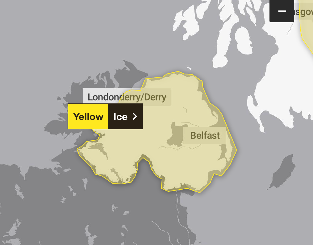
The Met Office says: “A scattering of showers around the coast this evening and overnight to give an ice risk, especially on untreated surfaces. Showers will turn to sleet or snow at times, perhaps giving a fresh dusting of snow in a few places.”
Recap: Storm batters UK
Thursday 8 January 2026 23:22 , Dan HaygarthStorm Goretti hit the UK on Thursday evening, after the Met Office issued a rare red warning issued for “dangerous, stormy” winds on the Isles of Scilly and Cornwall. Here is a recap:
Winds of 99mph were recorded at St Mary’s Airport on the Isles of Scilly, which is a new record for the site, the Met Office said.
Cornwall Council said trees and power lines had been reported felled and it was dealing with a large number of incidents. In its red warning, the Met Office said violent gusts would hit that part of the country, with speeds of 100mph forecast, between 4pm and 11pm on Thursday.
It said people should expect damage to buildings and homes, very large waves, flying debris resulting in danger to life, power cuts and public transport cancellations.
More than 47,000 properties were without power in the South West at about 9pm, according to National Grid’s website, while more than 5,000 had no power in the West Midlands and 2,000 in Wales.
The forecaster’s description of a red warning on its website reads: “It is very likely that there will be a risk to life, with substantial disruption to travel, energy supplies and possibly widespread damage to property and infrastructure.
“You should avoid travelling, where possible, and follow the advice of the emergency services and local authorities.”
Dozens of schools in Cornwall closed early on Thursday afternoon as the storm approached.
Network Rail said all trains in Cornwall would be suspended from 6pm on Thursday.
Elsewhere, Birmingham airport has suspended the use of its runway due to heavy snow.
An amber warning for snow covers parts of Wales, the Midlands and Yorkshire until 9am on Friday, with about 10 to 15cm of snow likely across the warning area, and up to 30cm on higher ground in Wales and the Peak District.
'Large number of incidents' in Cornwall
Thursday 8 January 2026 23:05 , Dan HaygarthIn a series of posts on X (formerly Twitter), Cornwall Council said: “We're dealing with a large number of incidents caused by Storm Goretti, including fallen trees, unsafe structures and downed power lines.
“If you can work from home on Friday morning, please do so, and avoid non-essential travel. Conditions remain dangerous.
“Parents and carers are advised to check whether their school or education setting is open before leaving home.”
The local authority added: “Please stay safe, allow emergency services and highways teams to carry out urgent work, and only travel if your journey is absolutely necessary.”
Watch as polar bears enjoy playing in snow as parts of Scotland covered
Thursday 8 January 2026 22:45 , Dan HaygarthBirmingham airport suspends runway operations
Thursday 8 January 2026 22:30 , Dan HaygarthDue to heavy snow runway operations have been suspended.
— Birmingham Airport (@bhx_official) January 8, 2026
Passengers due to travel should contact their airline regarding the status of flights.
The safety of our colleagues and customers is our number one priority and this decision has been made with this in mind. We… pic.twitter.com/N2br7jJbg3
Storm Goretti leaves 44,000 homes without power as ‘weather bomb’ hits the UK
Thursday 8 January 2026 22:16 , Dan HaygarthStorm Goretti brought a potentially deadly mix of violent winds, ice and heavy snow and rains on Thursday, forcing schools to close and leaving thousands of homes without power.
Gusts of up to 99mph were recorded as authorities issued a rare red warning – the highest level – of winds for the Isles of Scilly and Cornwall.
Emergency alerts were sent to mobile phones in the area so they sounded an alarm even if set to silent.
More than 40,000 properties in southwest England suffered power cuts, according to National Grid.
Read our full story: Storm Goretti leaves 44,000 homes without power as ‘weather bomb’ hits the UK
What is the Met Office's five-day weather forecast?
Thursday 8 January 2026 21:55 , Dan HaygarthThis evening and tonight
Storm Goretti will continue to move eastwards across England and Wales. Very strong and damaging wind gusts will move along the south coast. Rain turning to snow, heavy for central parts of England and Wales. Wintry showers and ice elsewhere.
Friday
Storm Goretti will slowly edge away, but rain and some snow continuing across the east of England. Sunny spells and a scattering of wintry showers elsewhere. Windy and feeling cold.
Outlook for Saturday to Monday
Fine on Saturday after a cold and icy start. Further wet and windy weather moving east through Sunday, with some hill snow in the north. Milder for all by Monday.
Birmingham airport runway closes, triggering diversions and cancellations
Thursday 8 January 2026 21:38 , Dan HaygarthThe Independent’s travel correspondent Simon Calder reports:
Thousands of passengers flying to or from Birmingham airport have had their plans wrecked by the closure of the runway.
The airport said in a statement: “Due to heavy snow runway operations have been suspended. Passengers due to travel should contact their airline regarding the status of flights. The safety of our colleagues and customers is our number one priority and this decision has been made with this in mind. We apologise for any inconvenience this may cause."
A flight from Amritsar in India landed at Heathrow when Birmingham could not accept arrivals. Five following flights, including Jet2 from Antalya and Gran Canaria, diverted to Manchester, and Ryanair’s inbound flight from Barcelona ended up at East Midlands airport. Some flights were simply cancelled, including Air France from Paris, KLM from Amsterdam and easyJet from Edinburgh.
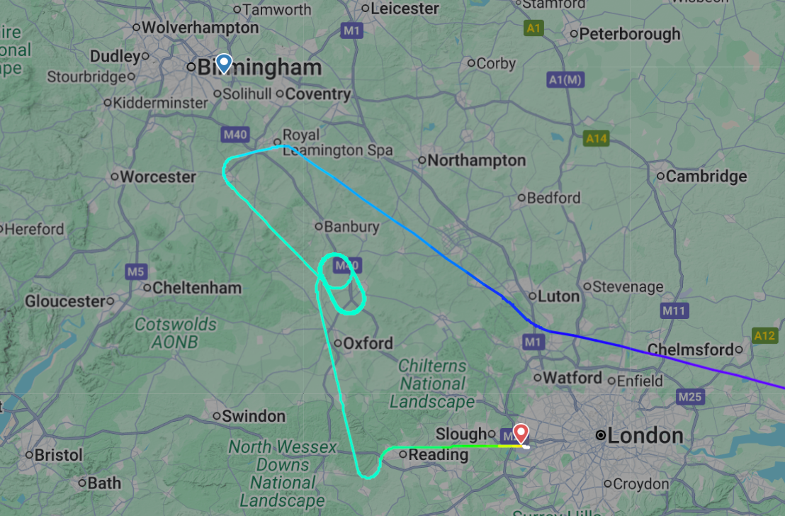
At least 1,000 passengers are waiting for the snow to be cleared. Some departing flights are delayed by five hours. The Emirates flight to Dubai is expected to leave over two hours late – jeopardising the connections of many people on board the A380 “SuperJumbo”.
Friday schedule is also affected because planes, pilots and cabin crew are out of position. Flights to Paris and Amsterdam due out in the morning are both cancelled.
Falmouth slammed by Storm Goretti winds
Thursday 8 January 2026 21:16 , Dan HaygarthHeavy winds are hitting Cornwall as the red weather warning remains in place.
Wet and windy conditions will continue into Friday
Thursday 8 January 2026 21:00 , Dan HaygarthA wet and windy start to Friday for much of England and Wales, with snow in places ⚠️
— Met Office (@metoffice) January 8, 2026
In Scotland, Northern Ireland and parts of NW England, a bright but cold start with frost and ice ❄️
Rain persisting for parts of east and southeast England, with wintry showers elsewhere 🌦️ pic.twitter.com/87nZByuagk
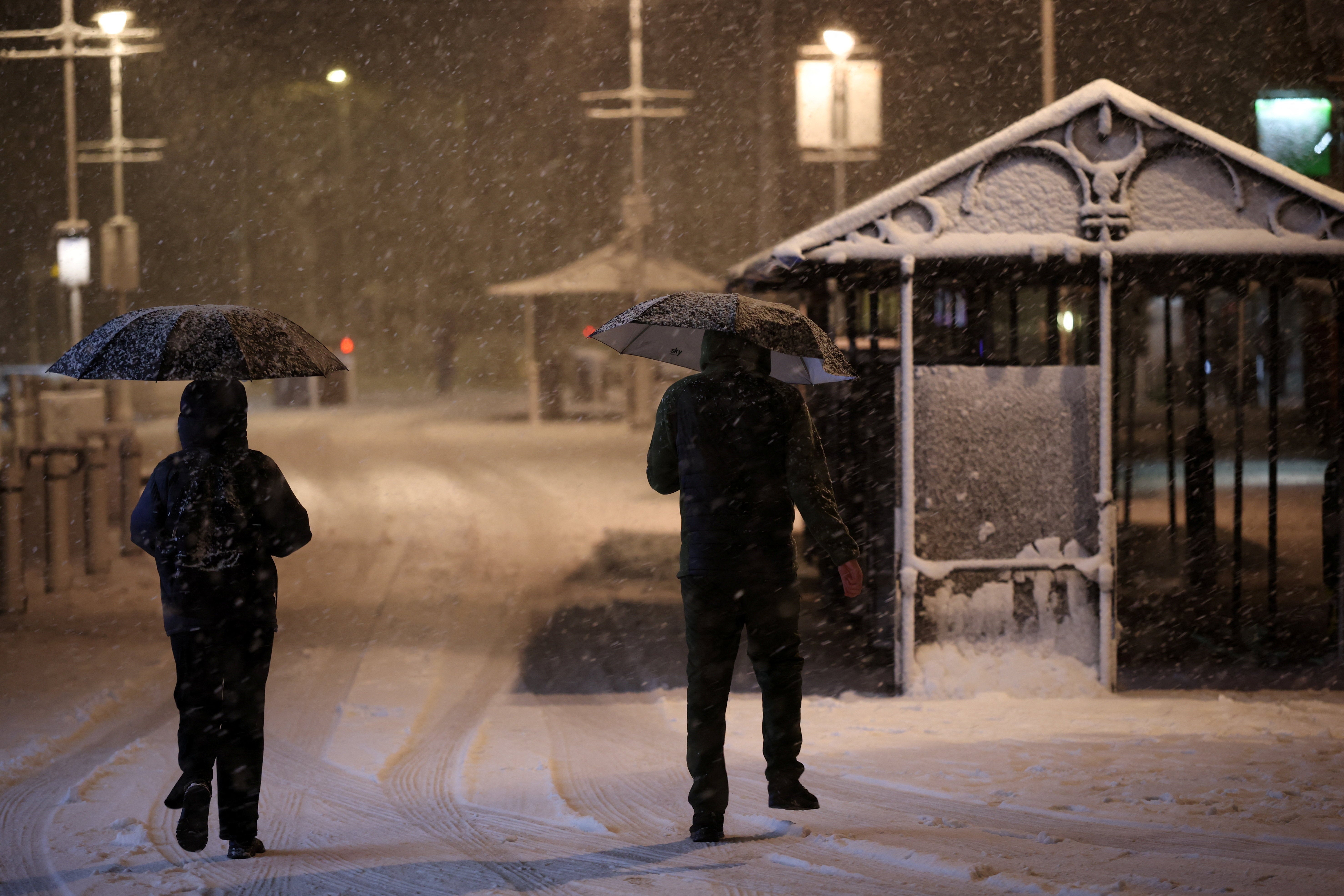
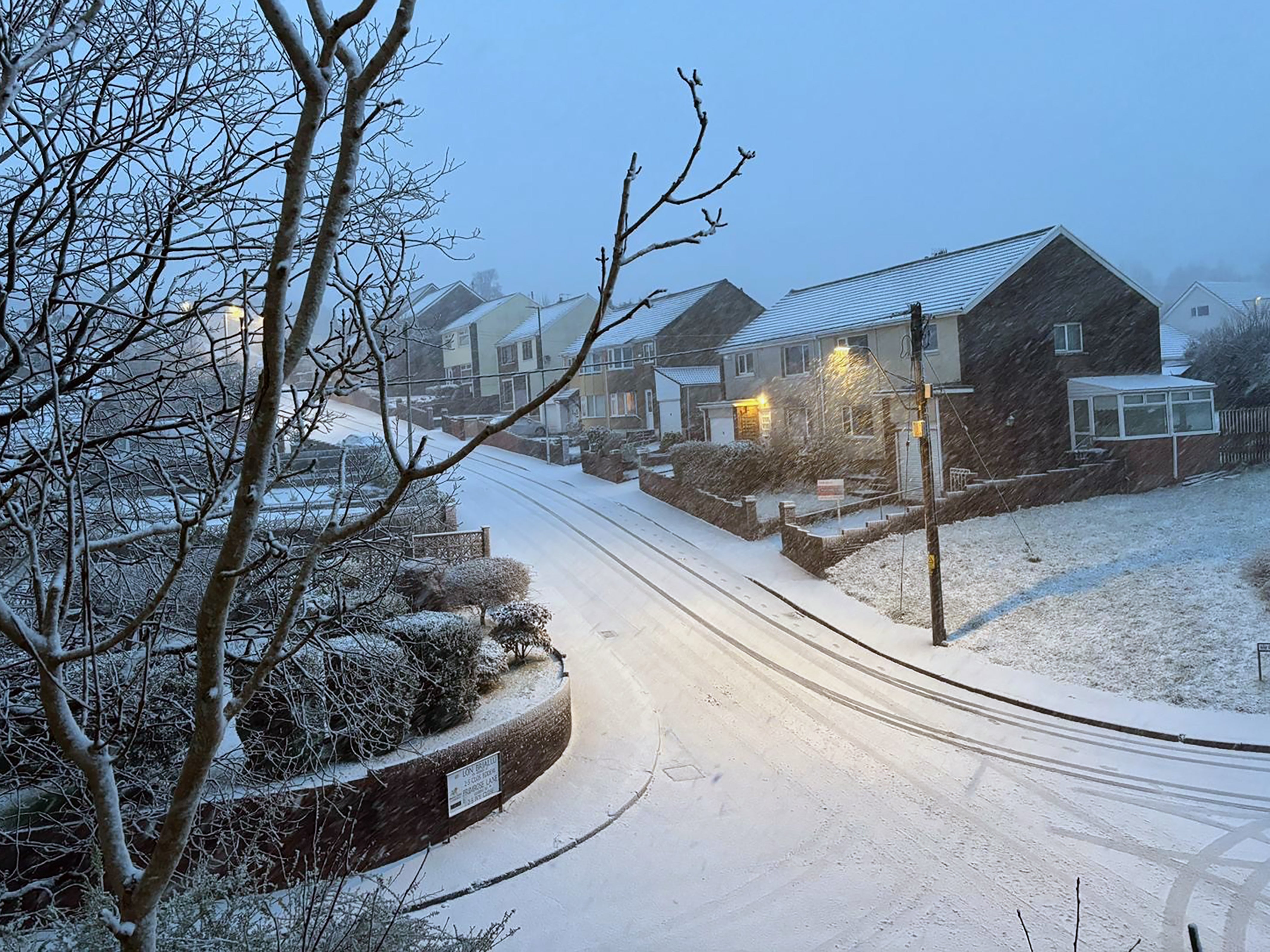
In pictures: Snow and stormy weather in the UK
Thursday 8 January 2026 20:45 , Dan Haygarth.jpeg)
Storm Goretti map - where the weather warnings are in place
Thursday 8 January 2026 20:30 , Dan Haygarth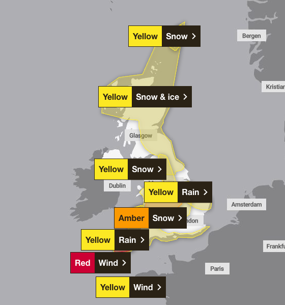
As well as the red warning, an amber weather warning is also in place from 8pm on Thursday evening to 9am on Friday, covering the Midlands, Yorkshire and parts of Wales.
The Met Office has warned it will bring 10 to 15cm of snow, with the potential for 20 to 30cm in some locations, mainly on hills, especially in Wales and the Peak District.
Read our full story: Where Britain will be hit by heavy snow and rare red weather warning for wind tonight
Reports of fallen trees and power lines in Cornwall
Thursday 8 January 2026 20:18 , Daniel HaygarthStorm Goretti is now hitting Cornwall and conditions are dangerous. Please stay indoors and do not travel.
— @cornwallcouncil (@CornwallCouncil) January 8, 2026
We're receiving reports of fallen trees and power lines and debris blocking roads. These conditions pose a serious risk to life.
Do not put yourself or others in danger. pic.twitter.com/UGOylgwHM3
Amber warning for snow now in force
Thursday 8 January 2026 20:06 , Dan HaygarthThe amber warning for snow is now in force across parts of the east Midlands, south west England, Wales, west Midlands, Yorkshire & Humber.
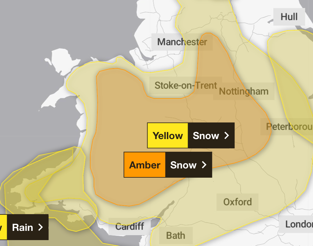
The Met Office says: “Heavy snow, associated with Storm Goretti, is likely to lead to disruption and dangerous travelling conditions Thursday night into Friday.”
It is in force from 8pm on Thursday to 9am on Friday.
Violent gusts could persist for hours in Cornwall and on the Isles of Scilly
Thursday 8 January 2026 19:50 , Dan HaygarthIn its red weather warning, the Met Office says: “Storm Goretti will bring a period of exceptionally strong northwesterly winds to the Isles of Scilly and parts of Cornwall on Thursday evening, with peak gusts of 80-100 mph or more in exposed areas.
“Winds are expected to increase rapidly from 30-40 mph with violent gusts that may persist for 2-3 hours before easing. Winds will remain strong with the broader yellow warning in force until Friday morning.
‘In addition, very large waves will bring dangerous conditions to some coastal areas.”
99mph wind recorded
Thursday 8 January 2026 19:29 , Dan HaygarthThe highest gust speed as a result of Storm Goretti is currently 99mph.
It was recorded at St Mary’s Airport on the Isles of Scilly, according to the Met Office.
It has also released the latest wind speeds at various spots in the south west.
The highest gust speed as a result of Storm Goretti is currently 99 mph, recorded at St Mary's Airport in the Isles of Scilly, making it a new record for the site
— Met Office (@metoffice) January 8, 2026
Here are the top gust speeds so far 👇 pic.twitter.com/jG99FBiJA5
Thousands of homes without power
Thursday 8 January 2026 19:16 , Dan HaygarthMore than 25,000 properties are without power in south-west England, according to the National Grid.
Just after 7pm on Thursday the number of premises off supply in the area was over 25,000.
What is a weather bomb?
Thursday 8 January 2026 19:10 , Daniel Haygarth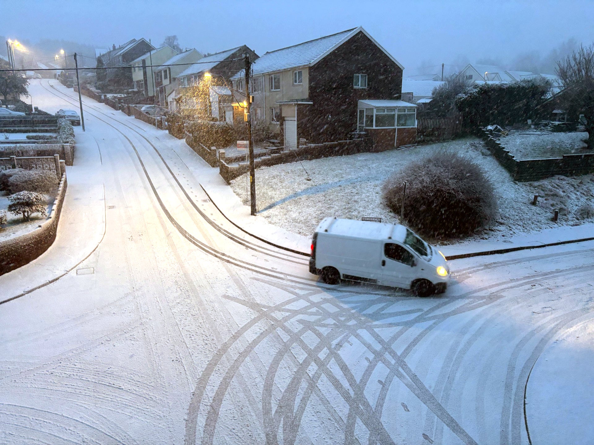
Also known as explosive cyclogenesis, a weather bomb is caused when the central pressure in an area of low pressure falls rapidly.
The pressure has to fall by 24 millibars in 24 hours to qualify.
According to the BBC, Storm Goretti will see a pressure drop of 36 millibars in the 24 hours from 6pm on Wednesday to 6pm on Thursday.
The Met Office said that winds during a weather bomb can be “strong enough to bring down trees and cause structural damage”.
'Storm Goretti will be a multi-hazard event'
Thursday 8 January 2026 18:40 , Dan HaygarthStorm Goretti has arrived in the UK bringing gusts of up to 100mph as a rare red warning for “dangerous, stormy” winds was issued.
The Met Office said “violent gusts” will hit parts of Cornwall and the Isles of Scilly over the next few hours bringing a potential danger to life.
Weather warnings have been issued for snow, wind, rain and ice across the country, ahead of likely “disruption and dangerous travelling conditions”.
Met Office chief forecaster Neil Armstrong said: “Storm Goretti will be a multi-hazard event, with the most significant impacts from snow in parts of Wales and the Midlands and the very strong winds in the far South West, though heavy rain in some parts of Wales and East Anglia also has the potential to bring disruption to many.
“Goretti will bring snow on its northern edge, this most likely over Wales and the Midlands. Here accumulations of 10-15cm are likely, widely, with 20-30cm possible in some places, especially higher ground in Wales and the Peak District.
“An amber warning has been issued where the greatest risk of disruption is likely on Thursday night into Friday morning.
“This is a complex spell of severe weather and I’d advise people in the warning areas to keep up to date with the forecast and messages from local authorities.”
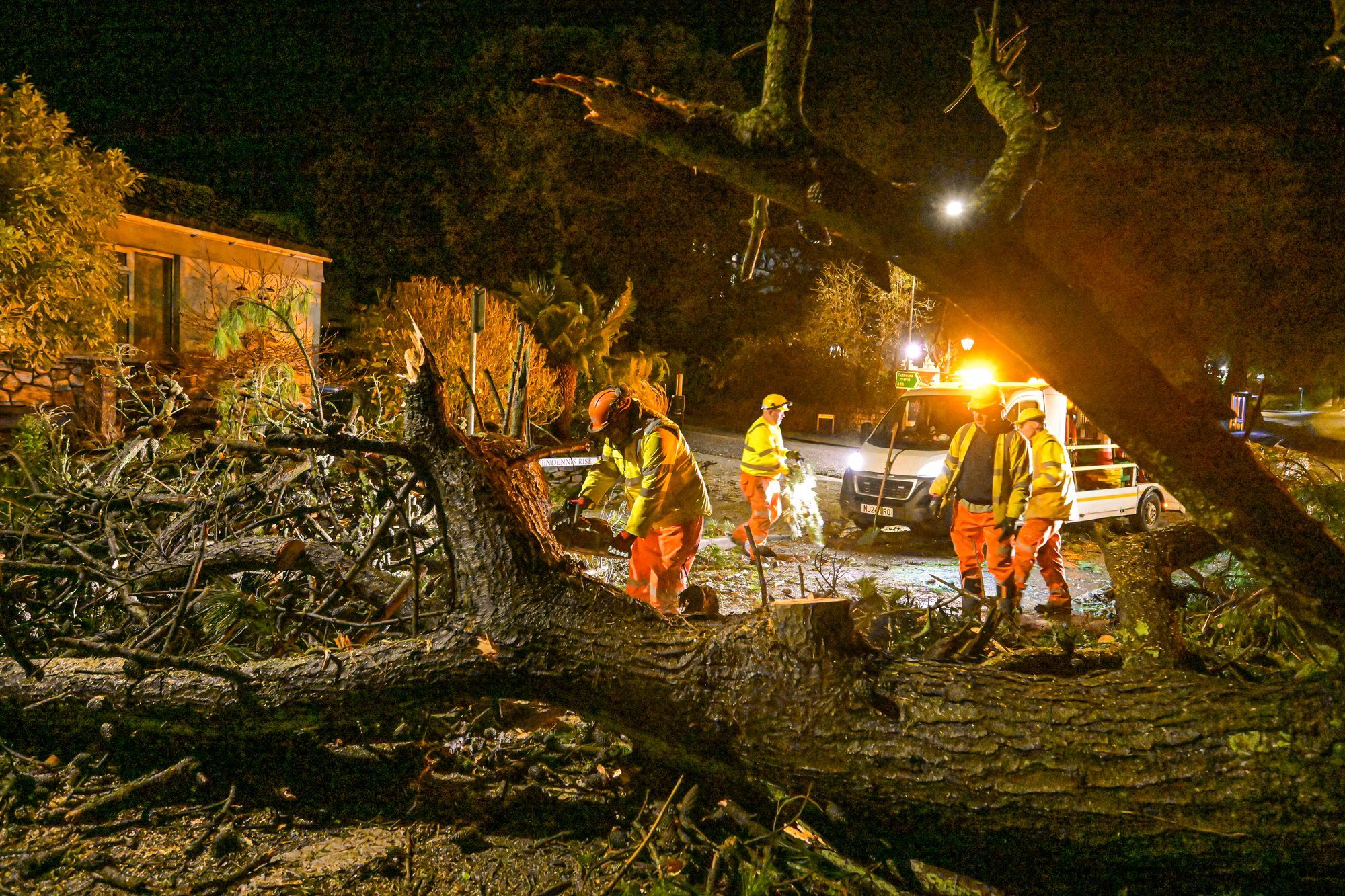
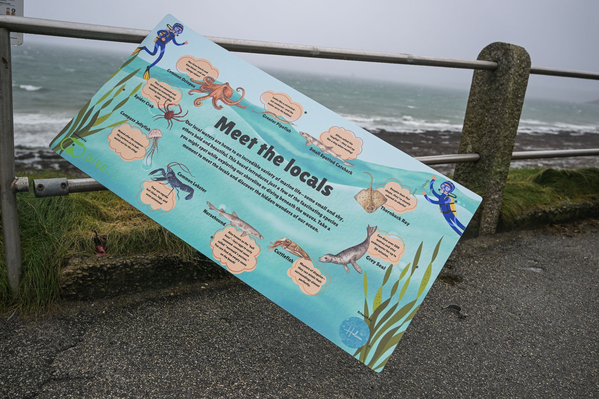
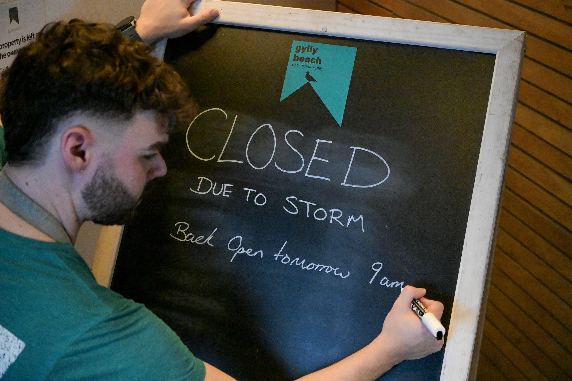
In pictures: The south west prepares for strong winds
Thursday 8 January 2026 18:27 , Dan Haygarth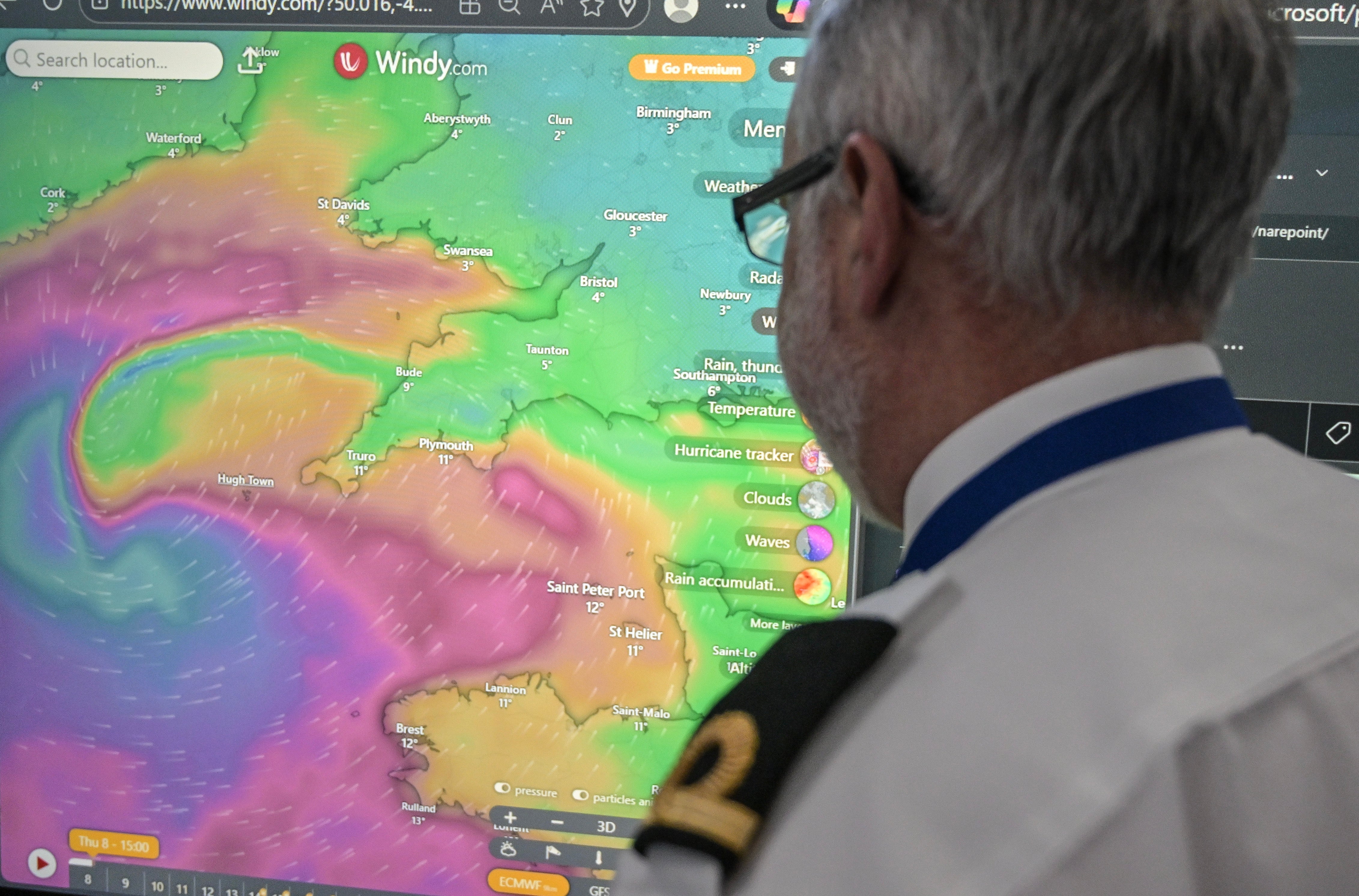

98mph winds recorded
Thursday 8 January 2026 18:22 , Dan HaygarthWinds of 98mph have been recorded at St Mary’s Airport on the Isles of Scilly.
The Met Office has issued a rare red warning for “dangerous, stormy” winds as Storm Goretti has arrived in the UK.
A recent gust of 98 mph has been recorded at St Mary's Airport on the Isles of Scilly, making it a new record for the site 🌬️ pic.twitter.com/rjRLj2iO0K
— Met Office (@metoffice) January 8, 2026
The Met Office posted on X saying: “A recent gust of 98mph has been recorded at St Mary’s Airport on the Isles of Scilly, making it a new record for the site.”
In pictures: Snowfall in the UK
Thursday 8 January 2026 18:14 , Daniel Haygarth
.jpeg)

Schools in affected areas to close on Friday
Thursday 8 January 2026 18:01 , Dan HaygarthDozens of schools will be closed on Friday, in areas where an amber weather warning for snow has been issued.
A number of schools across the Midlands and Wales have announced they will be shutting, as an amber warning for snow runs from 8pm until 9am on Friday covering parts of Wales, the Midlands and Yorkshire.
The Met Office said rain associated with the storm in these areas will turn to "heavy snow", which may lead to some rural communities being cut off.
About 10 to 15cm of snow is likely across the warning area, with up to 30cm on higher ground in Wales and the Peak District.
'Avoid the roads - unless absolutely essential'
Thursday 8 January 2026 17:56 , Dan HaygarthThe RAC has told people to avoid the roads, unless absolutely essential, as Goretti arrives in the UK.
RAC breakdown spokeswoman Alice Simpson said: “A red weather warning is every bit as serious as it sounds: avoid the roads – unless absolutely essential – until the storm winds have passed.
“With the worst conditions expected in Cornwall and the Isles of Scilly, we strongly urge motorists in these areas to stay safe by parking well away from trees that could be uprooted by the strongest winds the area has seen in years.
“Exposed routes and coastlines pose the greatest danger as motorists are completely exposed to the elements and risk being ‘buffeted’ across the road by sudden gusts.”
The storm, named by French weather forecaster Meteo France, has been described as a “multi-hazard event” by the Met Office, with as much of 30cm of snow possible in parts of the UK.
Weather warnings have been issued for snow, wind, rain and ice across the country, ahead of likely “disruption and dangerous travelling conditions”.
British Airways cancels 30 flights at London Heathrow
Thursday 8 January 2026 17:42 , Dan HaygarthThe Independent’s travel correspondent Simon Calder reports:
British Airways has cancelled 30 flights to and from London Heathrow as air-traffic controllers apply capacity restrictions.
BA has grounded domestic departures to Aberdeen, Edinburgh, Glasgow, Belfast and Manchester, as well as the corresponding arrivals.
Flights to Continental Europe are also affected, with cancellations to Milan Linate, Geneva, Berlin, Venice, Brussels, Lisbon, Paris CDG, Hamburg and Dublin.
The evening British Airways flight to Jersey and back had already been grounded due to the closure of the Channel Islands airport.
During adverse weather, ATC provider Nats reduces the arrivals rate to ensure sufficient separation between aircraft. As a result, airlines are obliged to reduce their schedules in proportion to their size at Heathrow. With more than 50 per cent of slots, BA is always far more affected than other carriers.
The only other airline currently with a Heathrow cancellation is Lufthansa from and to Frankfurt.
No trains west of Plymouth from 6pm – with cuts elsewhere on the network
Thursday 8 January 2026 17:31 , Dan HaygarthThe Independent’s travel correspondent Simon Calder reports:
Great Western Railway has set out its plans for coping with the onset of Storm Goretti – which is expected to sweep right across its network serving the West of England, south Wales and the Cotswolds.
No trains will run west of Plymouth on the line to Penzance after 6pm, including all branch lines in Cornwall.
Two branch lines in Devon – from Exeter to Barnstaple and to Okehampton – will also stop services at the same time.
From 7pm, no trains will run between Worcester and Great Malvern or Hereford.

The operator said: “To help you make your journey, you may use your ticket at no extra cost, on CrossCountry services from 4pm between Plymouth and Worcestershire Parkway [and] Transport for Wales services between Newport and Carmarthen.
“Replacement road transport will not be available as road conditions are expected to be at risk.
“While we hope to be able to run as close to a normal service elsewhere on the network, further disruption related to the storm is possible as the weather develops.”
Tickets dated for Thursday will be valid for Friday.
The emergency alert sent to people in Cornwall
Thursday 8 January 2026 17:17 , Dan HaygarthPeople in Cornwall have been sent another emergency alert to their mobile phones as Storm Goretti hits.
The alerts, which mean sounds blare from mobile phones, have been issued to people in the areas most at risk from Storm Goretti.
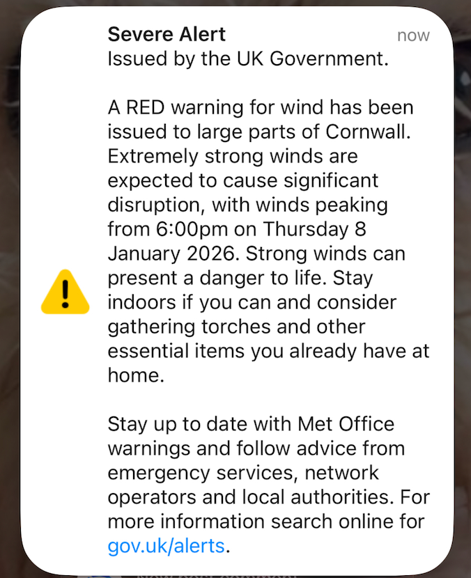
A Cabinet Office spokesman said: “The Met Office has issued a red warning for the Isles of Scilly and Cornwall from 4pm until 11pm on Thursday January 8.
“In light of the damaging winds and associated disruption, the Cabinet Office is issuing two Emergency Alerts to people in affected areas.
“The first was sent at approximately 3pm on Thursday January 8 to people in the Isles of Scilly. The second will be sent at approximately 5pm on Thursday January 8 to people in Cornwall.
“The Emergency Alert system will send a message to every compatible mobile phone in the impacted areas, containing information about the red warning and guidance on how to stay safe.
“Compatible mobile phones will make a loud siren-like sound even if they are set on silent. The sound and vibration will last for about 10 seconds.”
Where is the red weather warning in force?
Thursday 8 January 2026 17:01 , Dan HaygarthThe Met Office has issued a rare red weather warning, covering Cornwall and the Isles of Scilly, after updating it from amber.
It is in place due to “dangerous stormy winds” forecast between 4pm and 11pm on Thursday.
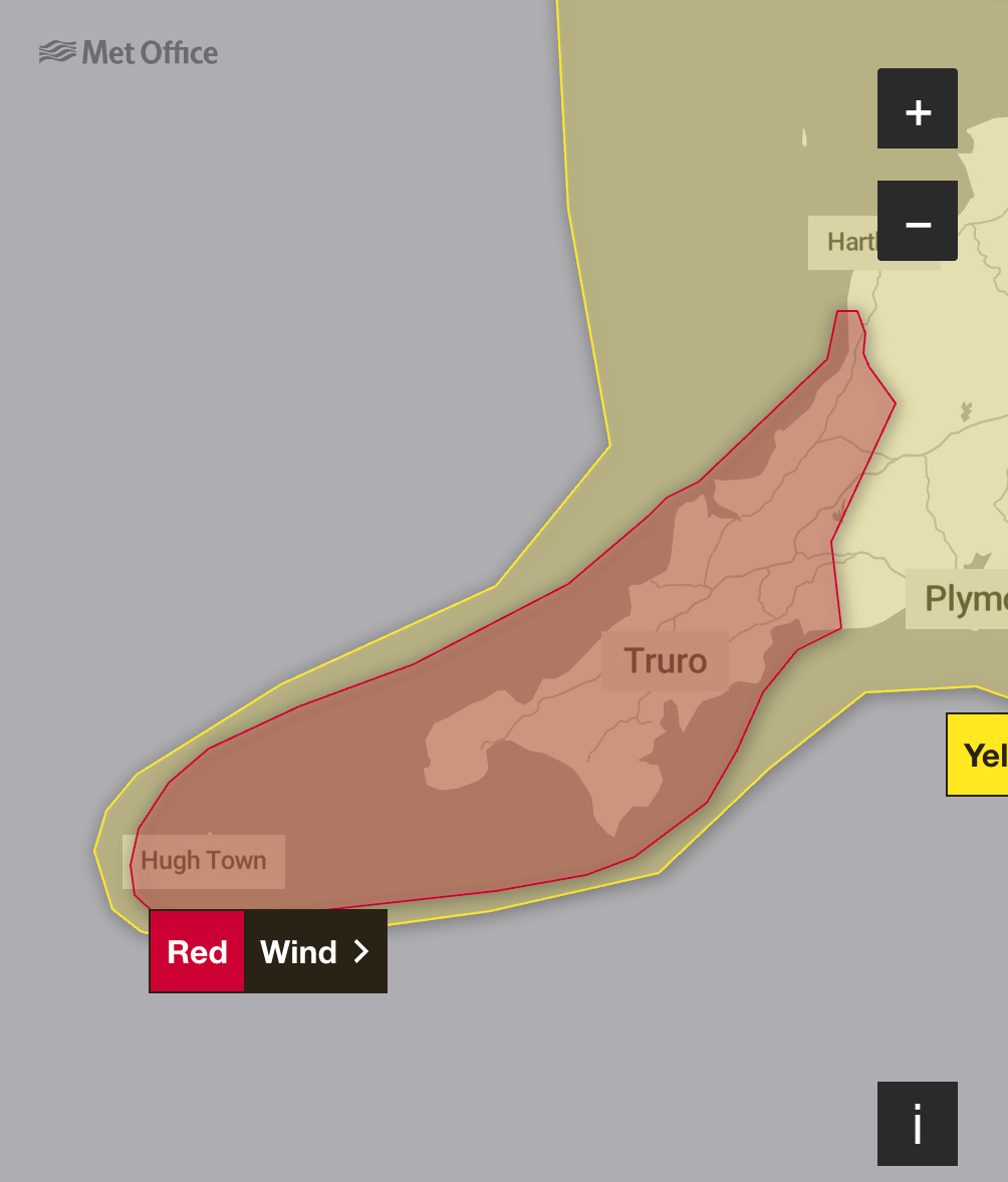
The Met Office says: “Storm Goretti will bring dangerous stormy winds for a time on Thursday evening.”
Issuing advice for people, it tells them to expect:
- Damage to buildings and homes, with roofs blown off and power lines brought down. Flying debris resulting in danger to life.
- Roads, bridges and railway lines closed, with delays and cancellations to bus, train, ferry services and flights
- Power cuts affecting other services, such as mobile phone coverage
- Very large waves and beach material being thrown onto coastal roads, sea fronts and homes
Postpone travel as late as Monday if you like, say rail firms
Thursday 8 January 2026 16:47 , Joe MiddletonThe Independent’s travel correspondent Simon Calder reports:
Some train operators are offering people with tickets for Thursday and Friday the chance to postpone their journeys as far ahead as Monday 12 January.
One of them is CrossCountry, which has joined GWR in cancelling all services west of Plymouth from 6pm on Thursday. In addition, no trains will run between Leicester and Peterborough from 8pm on Thursday, and the link between Coventry and Leamington Spa will be closed al day on Friday 9 January.
As Avanti West Coast cuts back services across its network, the firm is also making tickets more flexible. Anyone with a ticket dated Thursday 8 or Friday 9 January can use it to travel on the same route on any date up to and including Monday 12 January, at no extra cost.
The network connects London Euston with the West Midlands, northwest England, North Wales and southern Scotland.In addition, peak-hour restrictions have been lifted for Thursday afternoon and evening.LNER is allowing tickets dated Thursday 8 or Friday 9 January to be used to travel on the same route on any date up to and including Monday 12 January, at no extra cost.London Northwestern has the same policy.
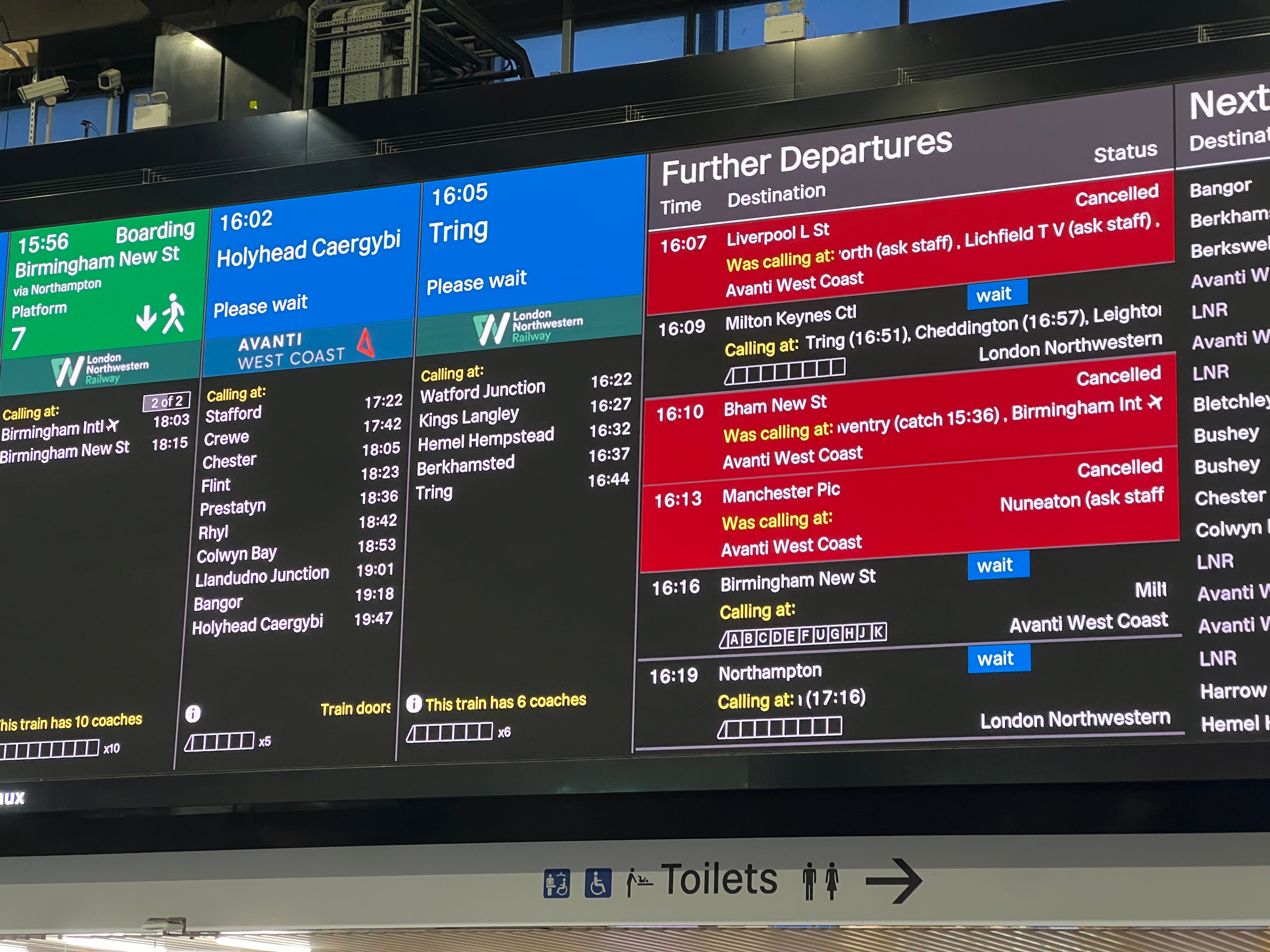
All trains in Cornwall to be suspended on Thursday evening
Thursday 8 January 2026 16:45 , Dan HaygarthNetwork Rail said all trains in Cornwall will be suspended from 6pm on Thursday because of a warning for strong winds.
In Devon, trains on the Exeter-Okehampton and Exeter-Barnstaple routes will be suspended from the same time because of forecast high wind speeds.
Passengers are advised to travel earlier and not to attempt travel late this afternoon.
Services on affected routes are also expected to be disrupted on Friday morning.
Replacement road transport will not be available as road conditions are also expected to be affected by the weather.
Elsewhere, Transport for Wales says six railway lines will be closed completely from 3pm on Thursday, with a reduced service on the remainder.
The standard advice from TfW is: “You cannot travel - there are no trains running and we are unable to run rail replacement bus services.”
Fears of lack of gritting as hospitals see more falls and crashes
Thursday 8 January 2026 16:30 , Dan HaygarthAmid the treacherous weather conditions, members of the public have taken to social media to air their grievances about a lack of grit on the roads and criticise local authorities.
One social media user from snow-laden Abderdeenshire said no grit had been put down in several days despite heavy snowfall.
He wrote on X: “Quite ridiculous that anyone @Aberdeenshire thinks they don’t need additional help with the snow. Onto day 6 or 7 for many. Streets still unploughed, no grit or salt provided or put down. It’s incompetence on a massive scale.”
Aberdeenshire Council declared a major incident this week, with three to six inches of snow widely reported to have fallen overnight.
The council stated in an update: “Our crews report that our primary network took a fair hit from those snow levels after a strong clearing effort again yesterday. We’re back out in force this morning but our focus on the vital primary routes may impact other route treatment so please bear with us.”
Read the full story: ‘Like Bambi on ice’: Fears of lack of gritting as hospitals see more falls and crashes amid ice warnings
In pictures: Storm Goretti captured on weather satellite
Thursday 8 January 2026 16:15 , Bryony Gooch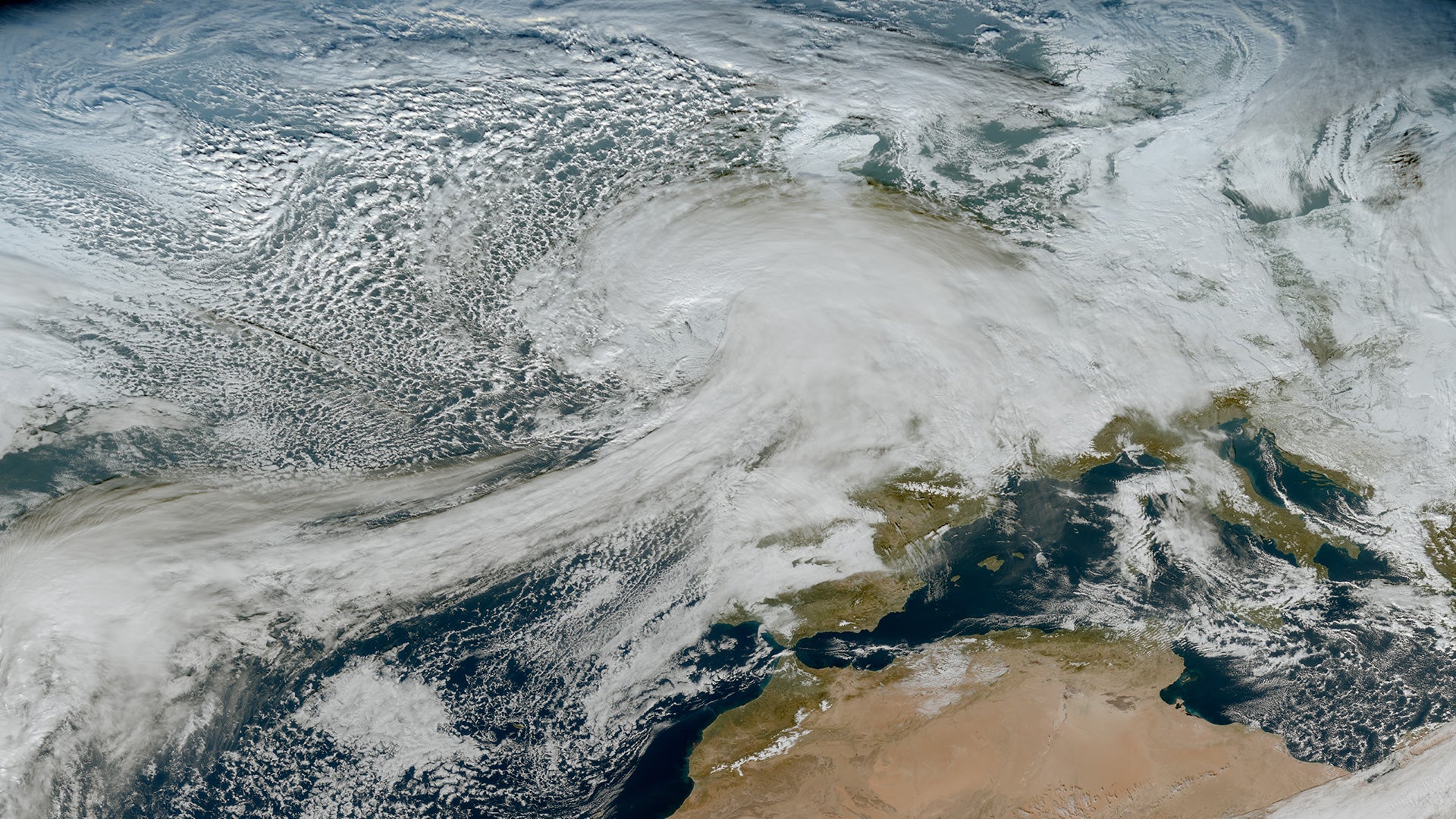
Storm Goretti mapped: Where Britain will be hit by heavy snow and ice
Thursday 8 January 2026 16:00 , Bryony Gooch
Storm Goretti map: Where Britain will be hit by heavy snow and high winds tonight
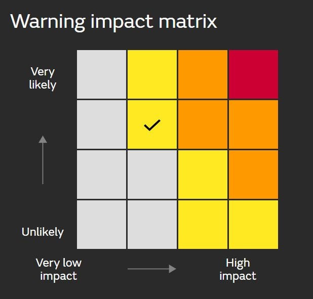
The Met Office warning system: what do the different colours mean?
Thursday 8 January 2026 15:45 , Bryony GoochYellow Warning: Yellow warnings can be issued for a range of weather situations, according to the Met Office. Many are issued when it is likely that the weather will cause some low level impacts, including some disruption to travel in a few places. Many people may be able to continue with their daily routine, but there will be some that will be directly impacted and so it is important to assess if you could be affected.
Other yellow warnings are issued when the weather could bring much more severe impacts to the majority of people but the certainty of those impacts occurring is much lower. It is important to read the content of yellow warnings to determine which weather situation is being covered by the yellow warning.
Amber Warning: There is an increased likelihood of impacts from severe weather, which could potentially disrupt your plans. This means there is the possibility of travel delays, road and rail closures, power cuts and the potential risk to life and property, the Met Office said.
You should think about changing your plans and taking action to protect yourself and your property. You may want to consider the impact of the weather on your family and your community and whether there is anything you need to do ahead of the severe weather to minimise the impact.
Red Warning: Dangerous weather is expected and, if you haven’t already done so, you should take action now to keep yourself and others safe from the impact of the severe weather.
It is very likely that there will be a risk to life, with substantial disruption to travel, energy supplies and possibly widespread damage to property and infrastructure, according to the Met Office. You should avoid travelling, where possible, and follow the advice of the emergency services and local authorities.
Emergency alerts sent as red weather warning issued
Thursday 8 January 2026 15:34 , Bryony GoochEmergency alerts have been sent as the Met Office has issued a red weather warning for the Isles of Scilly and Cornwall.
Emergency alerts happen when sounds blare from mobile phones. People in the areas most at risk from Storm Goretti will have received them.
A Cabinet Office spokesperson said: "The Met Office has issued a red warning for the Isles of Scilly and Cornwall from 4pm to 11pm on Thursday 8th January.
"In light of the damaging winds and associated disruption, the Cabinet Office is issuing two Emergency Alerts to people in affected areas. The first was sent at approximately 3pm on Thursday 8th January to people in the Isles of Scilly. The second will be sent at approximately 5pm on Thursday 8th January to people in Cornwall.
"The Emergency Alert system will send a message to every compatible mobile phone in the impacted areas, containing information about the red warning and guidance on how to stay safe.
"Compatible mobile phones will make a loud siren-like sound even if they are set on silent. The sound and vibration will last for about 10 seconds.
"The UK Government has well rehearsed plans in place for severe winter weather and is working with teams from local authorities, the emergency services, and other public bodies to coordinate the response to any disruption."
Mapped: What weather warnings are impacting the rest of England?
Thursday 8 January 2026 15:30 , Bryony GoochAmber snow warning across the Midlands, Wales, Yorkshire and Gloucestershire: From 8pm today until 9am tomorrow, rain associated with Storm Goretti will turn readily to heavy snow. Accumulations of 10-15 cm are likely fairly widely, with the potential for 20-30 cm in some locations, mainly on hills above 200 m elevation, more especially in Wales and/or the Peak District.
Yellow snow warning in the Midlands, the East of England, South East England, the North of England, the South West of England and Wales: From 5pm today until midday tomorrow, Storm Goretti is expected to bring heavy snow. Whilst not all areas may see accumulating snow, accumulations of 5-10 cm are likely quite widely, with scope for 15-25 cm in places, especially on some hills above 200 metres elevation. There is a chance of 30 cm accumulating over high ground in Wales and/or the Peak District.
Yellow rain warning in Yorkshire and the East of England: From 6pm today until 9pm tomorrow, heavy and persistent rain may lead to some flooding and disruption. 20-30 mm rainfall is likely quite widely, with a small chance of 40-60 mm in a few places, and strong winds, especially near coasts, will be an additional hazard with winds gusting 40-50 mph at times and leading to large waves through Friday.
Rail closures now in effect in Wales – as Avanti West Coast cuts trains
Thursday 8 January 2026 15:30 , Bryony GoochTravel correspondent Simon Calder reports:
Transport for Wales says six railway lines will be closed completely from 3pm on Thursday, with a reduced service on the remainder. The standard advice from TfW is: “You cannot travel - there are no trains running and we are unable to run rail replacement bus services.”
The closed lines include the Heart of Wales line and all services west of Carmarthen.
The effect is being felt outside the nation: Transport for Wales runs trains between Liverpool and Chester, and has cancelled all services. “Network Rail have reported weather warnings for heavy sleet and snow in the area and have closed the railway to all services after 3pm, says TfW.
Avanti West Coast has started cancelling trains across its network – removing one of the three trains each hour between London Euston and each of Birmingham New Street and Manchester Piccadilly.
Mapped: What weather warnings are impacting Scotland and the north of England:
Thursday 8 January 2026 15:23 , Bryony GoochYellow snow warning in the Shetland Islands: Between 4pm and 8pm today, outbreaks of sleet and snow are expected to become heavy at times this afternoon and early evening. Accumulations of 1 to 3cm are expected at low levels with 5 to 10cm over the hills.
Yellow snow and ice warning in Scotland and the north of England: From 8pm today until midday tomorrow, ice is expected to form widely again as surfaces refreeze through the evening and overnight. Scattered wintry showers will move inland across parts of northern England and eastern Scotland this evening and overnight into Friday. Showers may lead to some further modest snow accumulations of a few cms inland and over higher ground.
Weekend weather forecast
Thursday 8 January 2026 15:15 , Bryony GoochStorm Goretti’s influence will wane on Friday evening as the system moves to the east of England. There will be a short-lived interlude of calmer weather for many on Saturday with rain showers easing, cloud for those in the east, and sunny spells possible elsewhere.
However, by Sunday further unsettled weather will move in from the west. As milder Atlantic air tries to displace the cold air over the UK it brings a risk of some further widespread snowfall and strong winds in the north of the UK and rain further south. There is still some uncertainty in the detail for the second part of the weekend so it’s important to stay up to date with the forecast.
The current outlook for next week is for the milder air to push across the UK, ending this current spell of cold weather and opening the door to temperatures closer to average for the time of year as well as further areas of low pressure bringing wet and windy spells from the west.
Mapped: What weather alerts are affecting the south west of England?
Thursday 8 January 2026 15:03 , Bryony GoochRed wind warning for Cornwall and Isles of Scilly: From 4pm until 11pm today, Storm Goretti will bring a period of exceptionally strong northwesterly winds to the Isles of Scilly and parts of Cornwall on Thursday evening, with peak gusts of 80-100 mph or more in exposed areas. Winds are expected to increase rapidly from 30-40 mph with violent gusts that may persist for 2-3 hours before easing. Winds will remain strong with the broader yellow warning in force until Friday morning.
Yellow rain warning in Wales: From midday today until 10am tomorrow, Storm Goretti will bring a spell of heavy rain and hill snow. Rain accumulations of 20-40 mm are possible, with perhaps as much as 60 mm in a few places. This, combined with snow melt, may lead to some surface water flooding.
Yellow wind warning in the south east and south west of England and Pembrokeshire: From 3pm today until 6am tomorrow, Storm Goretti will bring a spell of strong winds with peak gusts of 50-60 mph likely fairly widely, and 60-70 mph along exposed coasts and hills. Winds will gradually ease through the early hours of Friday.
When was the last red warning?
Thursday 8 January 2026 14:35 , Bryony GoochA Met Office spokesperson said it was very rare to have red warnings.
The last red warning we had was January 2025 during Storm Eowyn. It’s notable because the weather forecast is dangerous and disruptive and there’s a high degree of confidence.
BREAKING: Met Office issues rare red weather warning
Thursday 8 January 2026 14:07 , Bryony GoochA weather warning for wind in parts of south-west England has been upgraded to red between 4pm and 11pm.
“Storm Goretti will bring dangerous stormy winds for a time on Thursday evening,” the Met Office said.
“Dangerous” winds of up to 100mph are expected.