Further flooding is expected in the wake of of Storm Chandra on Thursday and Friday, as fears grow that heavy rainfall could bring the worst floods seen in more than a decade.
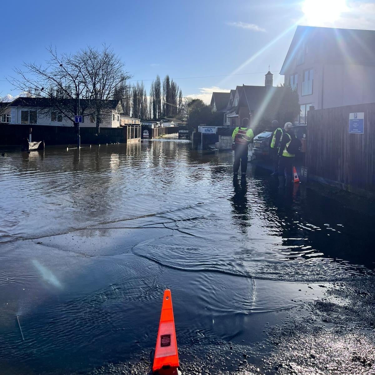
Already, more than 60 properties across England have been flooded following the storm earlier this week, while a major incident was declared on Somerset on Tuesday.
Dozens of flood warnings remain in place, including a severe “danger to life” warning in at Ilford Bridge Home Park in Dorset, where residents have been forced to evacuate.
The Met Office has issued a warning for rain in the south west of England from noon until Friday. Rain will be falling on already saturated ground, leading to concerns of further flooding.
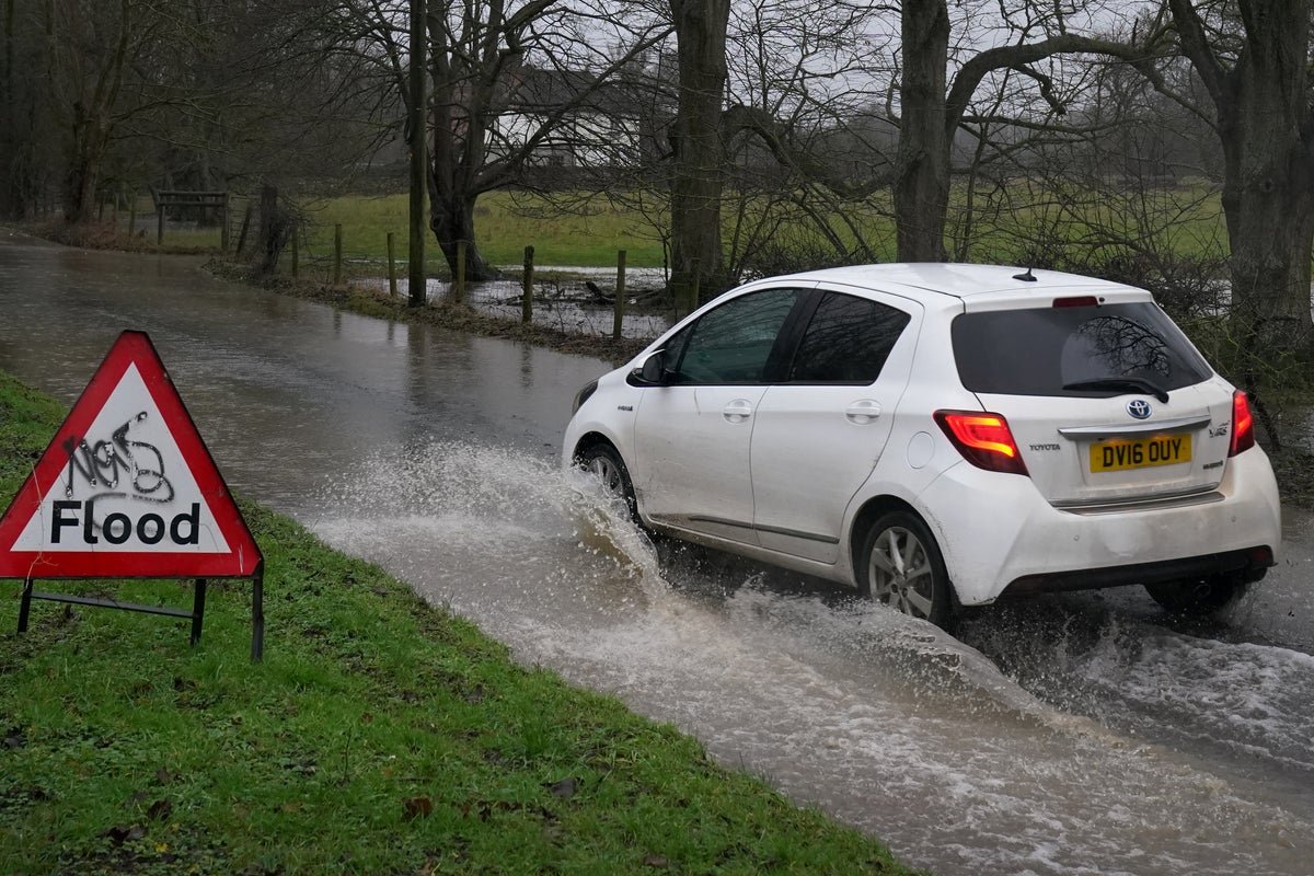
Roads in the West Country have also been blocked by flooding, while National Rail has warned of railway disruptions up until Friday.
Additionally, parts of the UK are set to be blanketed by snow as temperatures plummet in the aftermath of the storm. Chilly conditions will sweep the north of Scotland from Thursday, with some snow forecast in the north east, as much of the country wakes up to fog.
Retired couple fear ‘scariest’ Storm Chandra flooding as major incident declared
Storm Chandra sparks disruption across train network with GWR and ScotRail hit
UK weather map: Where heavy rain is expected to hit after Storm Chandra
Full list of UK schools closed today as Storm Chandra brings ‘extensive’ flooding and ice warnings
Key Points
- Snow expected in parts of Scotland on Thursday
- Drivers urged to carry floodkits due to heavy rain
- Met Office issues warning over heavy rain in Storm Chandra aftermath
- Yellow weather warning issued for Thursday
- Storm Chandra mapped
- Weather to affect Great Western Railway until end of Friday
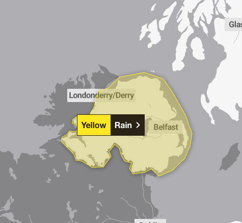
Weather warning for Northern Ireland on Friday
13:00 , Daniel HaygarthA yellow warning for rain is in force from midnight to 6pm on Friday.
The Met Office says: “Spells of heavy rain will move over Northern Ireland during Thursday night and Friday.
“While the wettest conditions are likely over Antrim and Down, there is potential for many areas to see 10-25 mm build up, with 40-60 mm over some hills. Rain will be accompanied by strong southeasterly winds, especially Thursday night and early Friday.”
Thursday's weather warning
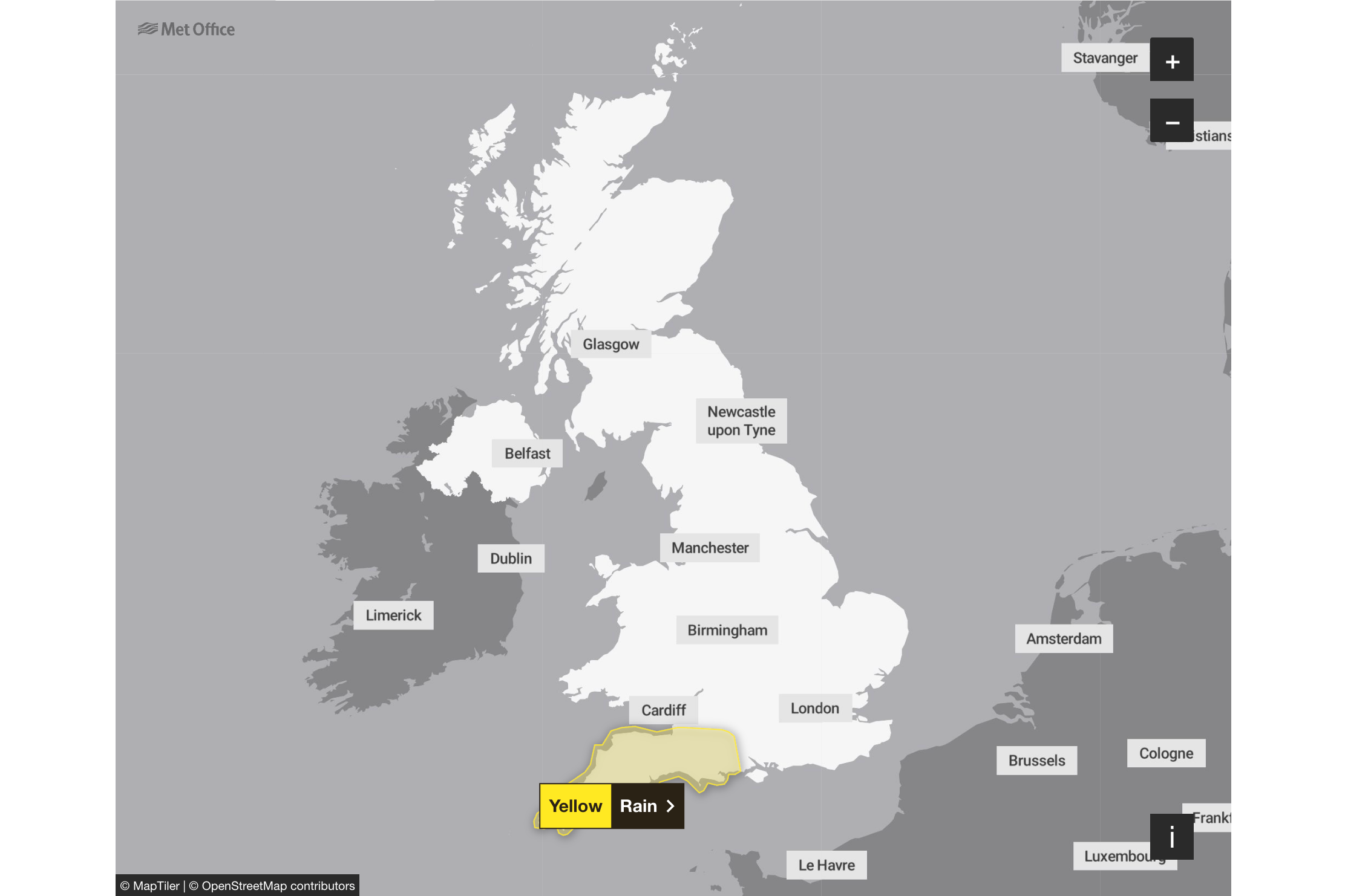
12:45 , Dan HaygarthA yellow weather warning for rain is in force from midday on Thursday to 3am on Friday, covering South West England.
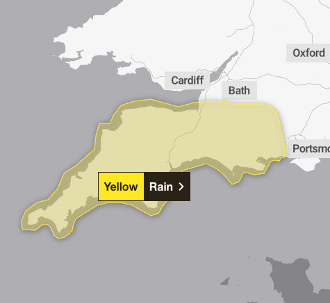
The Met Office says: : ”A band of rain will arrive across Cornwall on Thursday afternoon then move northeast across the warning area through the evening and clearing during early Friday.
“The rain is only likely to last for a few hours in any one location but will be at heavy at times. A further 10-15 mm of rain is expected fairly widely, but some locations, most likely in the south of the area, could see 20-25 mm.
“The likelihood of impacts from these rainfall amounts is higher than normal due to saturated ground and ongoing flooding following Storm Chandra.”
Union calls for 'climate leave' when weather makes it impossible to get to work
12:15 , Dan HaygarthA trade union has reiterated a call for the introduction of climate leave when extreme weather makes it impossible to get to work, as parts of Ireland deal with the clean-up after Storm Chandra.
It is part of a series of proposals from Unite on Thursday, while people dealt with serious traffic disruptions because of flooding and debris on road and rail routes.
Heavy winds and torrential rain on Tuesday caused significant disruption across the island of Ireland, including power outages, flight cancellations and 300 school closures in Northern Ireland.
Rivers burst their banks, including the Slaney in Co Wexford and the Dodder in Dublin, with fallen trees reported across the island.
Up to 20,000 properties were without power at the peak of Storm Chandra.
Unite has called for four days paid leave if extreme weather makes it impossible to travel to work and four days paid leave to be available if workers need to address needs at their home.
The union’s demands also include a legal obligation on employers to implement graduated alert-based responses, with non-essential outdoor work ceasing during amber/orange alerts and all non-essential work ceasing during red alerts.
They say that workers should be paid as usual for days where work is required to stop because of the weather.
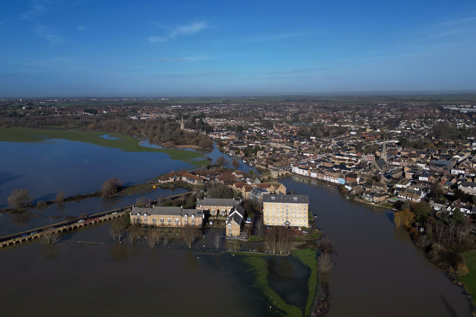
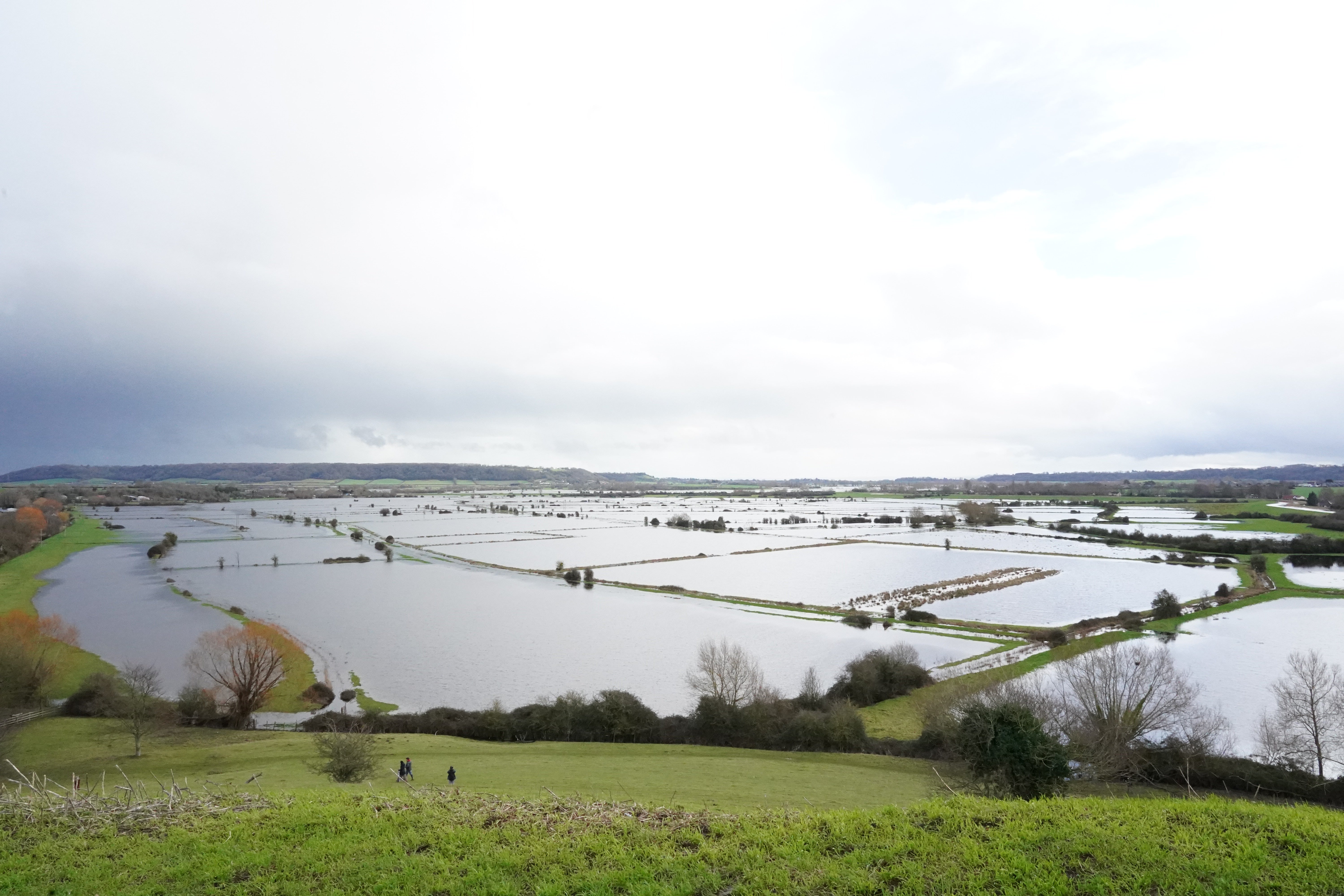
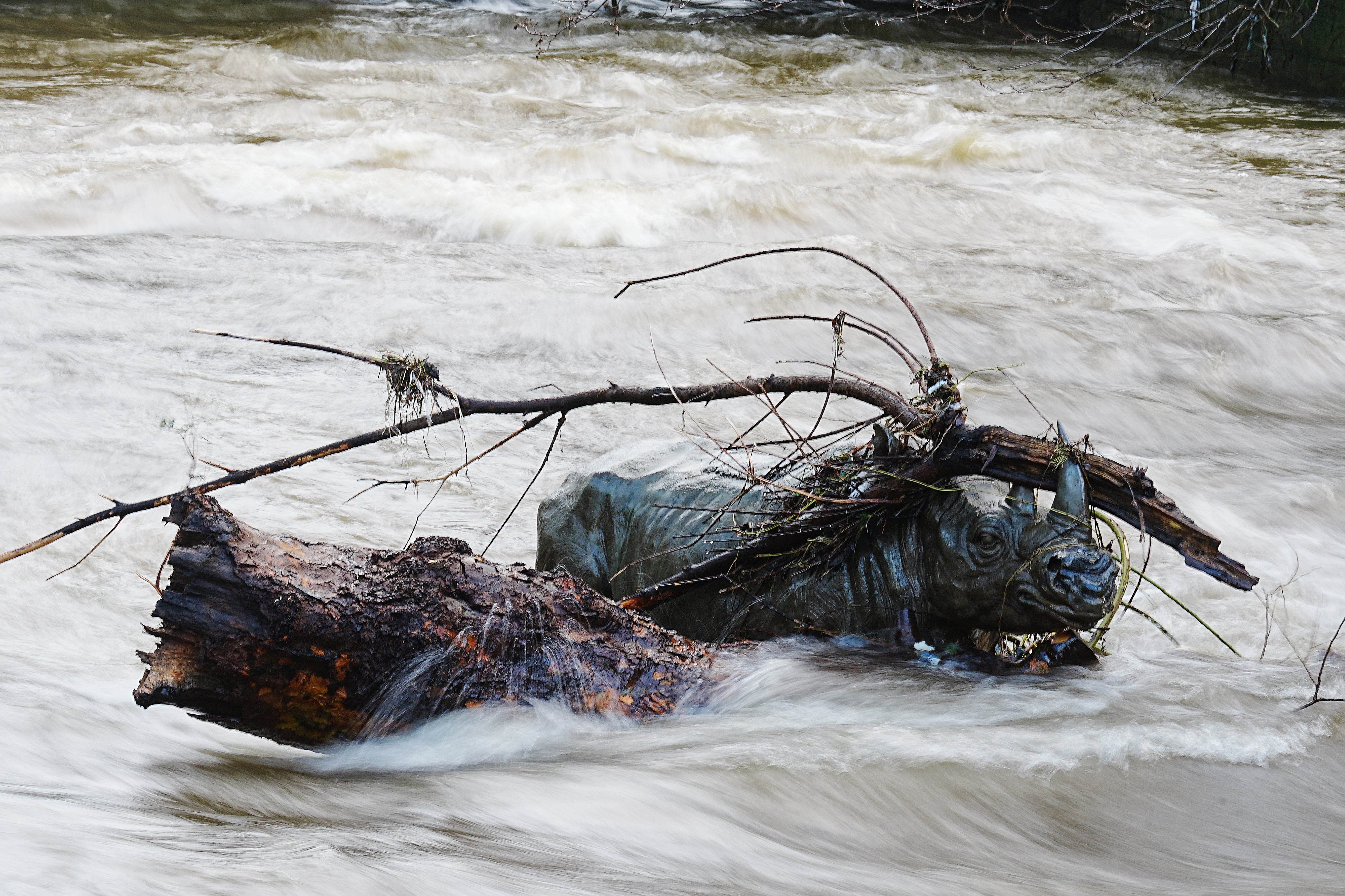
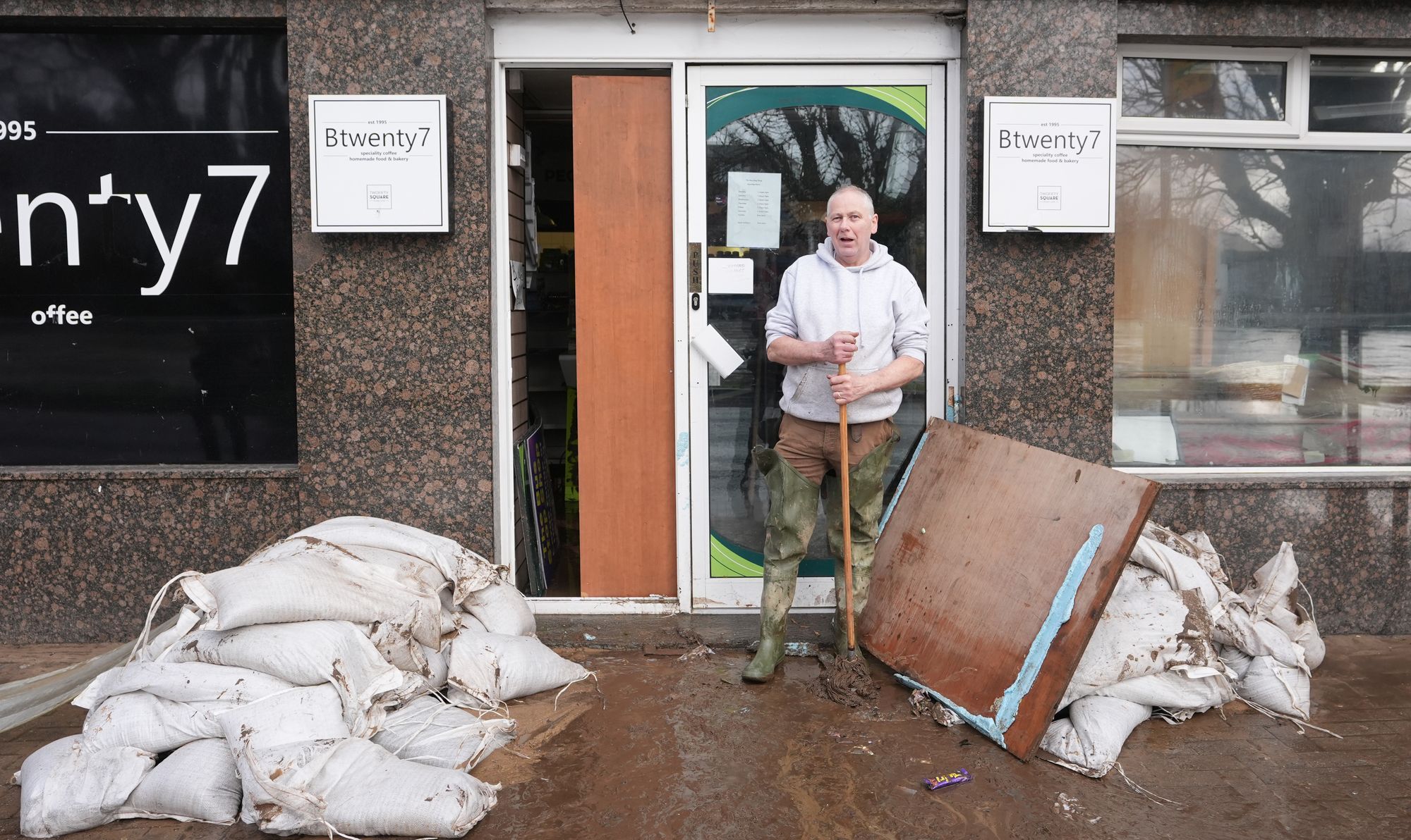
In pictures: Flooding hits parts of England
11:45 , Dan Haygarth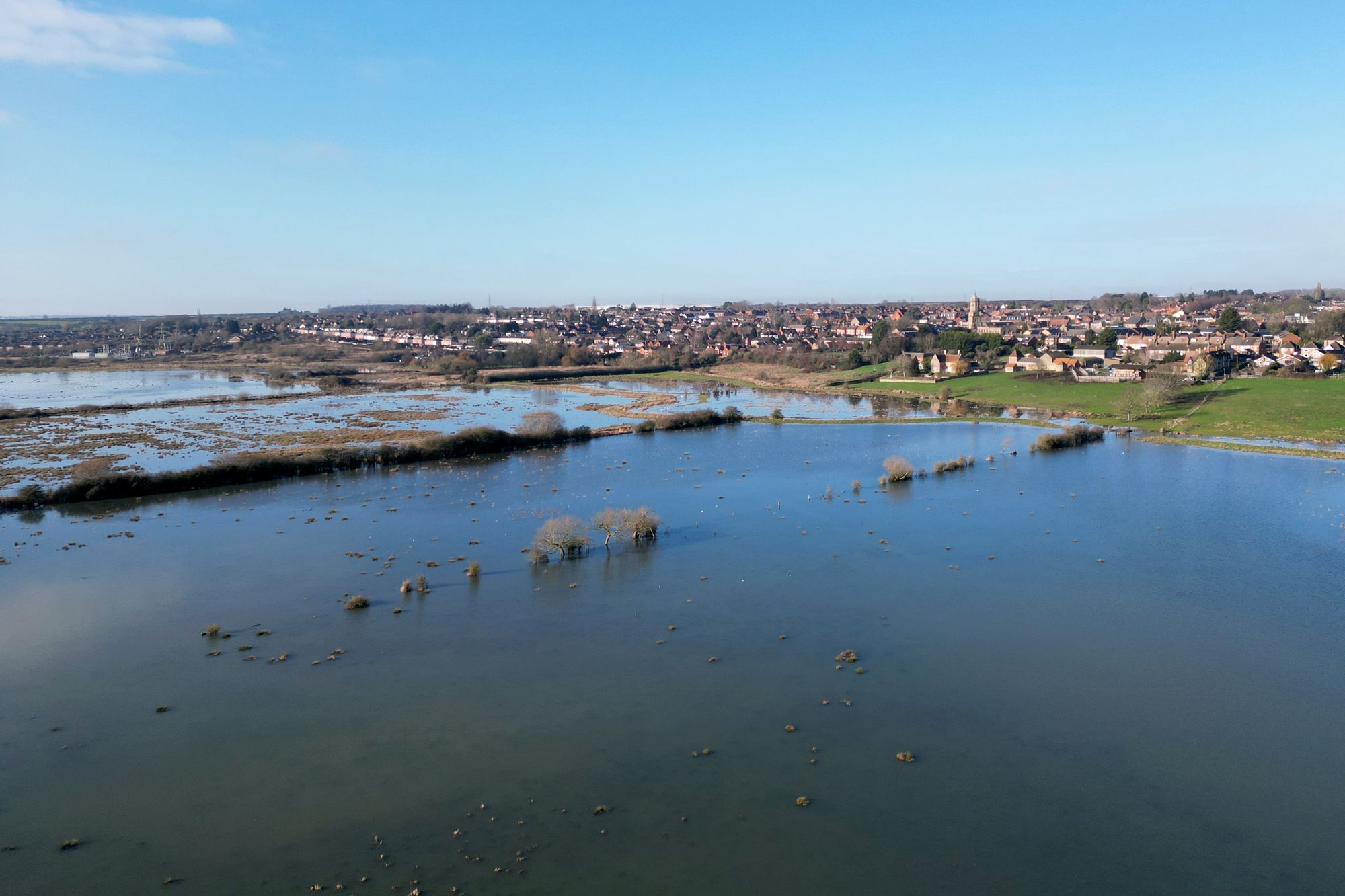
Weather to affect Great Western Railway until end of Friday
11:25 , Dan HaygarthNational Rail says: “The Met Office have issued yellow weather warnings across south west England throughout the day.
“As a result, trains running across the Great Western Railway network may be cancelled, delayed, revised or suspended.
“Disruption to services is expected to continue until the end of the day on Friday 30 January.”
It adds: “If you are travelling between Exeter St Davids and Okehampton / Barnstaple:
“You are advised NOT TO TRAVEL as Great Western Railway cannot guarantee they will get you to your destination due to the unsafe road conditions.
“Trains are currently unable to operate between these stations as a result of flooding following the poor weather.
“This is expected to be the case until the end of the day on Friday 30 January.
“An extremely limited rail replacement service will run between Exeter St Davids and Okehampton. Please speak to station staff on arrival.”
'Flooding is devastating', floods minister says
11:15 , Nicole Wootton-CaneFloods minister Emma Hardy said: “Flooding is devastating and my thoughts are with the people affected.
“I am in regular contact with the Environment Agency on their response to the ongoing flooding in Somerset and Dorset who, alongside local authorities and the emergency services, are already taking action to keep communities safe.
“I urge residents to follow local advice over the next few days to ensure they stay safe.”

Lorry driver dies after crashing into river in Hampshire
10:45 , Nicole Wootton-CaneA lorry driver died in the New Forest after crashing into a river on Tuesday in the aftermath of Storm Chandra.
Hampshire Police said a man, who was in his 60s, was pronounced dead at the scene of the incident in North Gorley.
“We were called just after 1pm on Tuesday to a report that a lorry had gone into a river off Ringwood Road in North Gorley,” a force spokesman said.
“Sadly the driver, a man in his 60s, was pronounced deceased at the scene.
“Inquiries are ongoing to establish the circumstances surrounding his death.”
Retired couple's fear over 'scariest' flooding in over a decade
10:15 , Nicole Wootton-CaneA retired couple are fearing the worst flooding in over a decade with heavy rainfall set to fall on Thursday.
Lesley and John Parker, from Burrowbridge in Somerset, say they have installed flood defences, concerned water will come "straight up through the floor".
Mr and Mrs Parker said the conditions are the scariest they have seen since their home was devastated by flooding in 2014, when 3ft of water inside the house forced them to evacuate.
You can read more below:

Retired couple fear ‘scariest’ Storm Chandra flooding as major incident declared
Watch: Otterton Mill devastated by Storm Chandra flooding
09:45 , Nicole Wootton-CaneFull list of UK schools closed today
09:15 , Nicole Wootton-Cane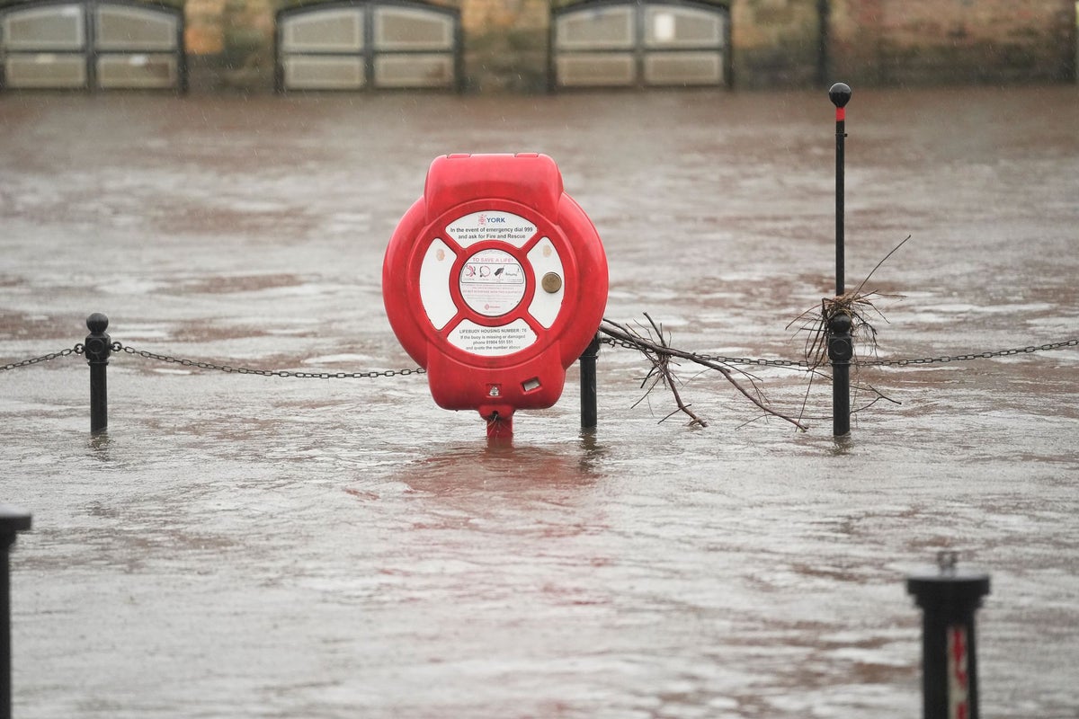
Full list of UK schools closed today as Storm Chandra brings flooding and ice warning
Britons hit by record January rainfall
09:00 , Nicole Wootton-CaneStorm Chandra has brought widespread disruption across the UK with many roads flooded, hundreds of school closures and dozens of flights cancelled – as parts of the country brace for icy weather on Wednesday morning.
The storm has broken January daily rainfall records, with drivers being urged to check for road closures and avoid travelling on flooded roads.
You can read more below:
Britons hit by record rainfall as Storm Chandra causes travel chaos and flooding
Rail disruption expected to last all weekend
08:45 , Nicole Wootton-CaneDisruption to rail lines in the worst affected parts of the country could last all weekend following severe flooding, according to authorities.
National Rail said the line between Liskeard and Looe in Cornwall will be closed until the end of the day on Sunday after flooding on the tracks.
“The heavy rainfall, combined with high tides, resulted in the water levels at several bridges along the line being above the level which allows for trains to run safely,” its website reads.
“Investigations took place once the water levels receded and the results of the investigations have confirmed some damage that will require repair work.
“This will need to be carried out before the line can be reopened and trains are able to run again.”
UK weather map: Where heavy rain is expected to hit after Storm Chandra
08:30 , Nicole Wootton-CaneHeavy rain will batter parts of the UK on Thursday as areas of the country struggle to get to grips with the rainfall brought by Storm Chandra.
A yellow weather warning is in place in the south west from midday on Thursday to 3am on Friday, with a further 10-15 mm of rain expected in the affected area.
You can read more about the weather warning below:
UK weather map: Where heavy rain is expected to hit after Storm Chandra
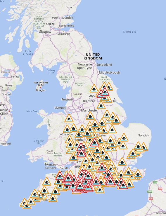
Flood warnings in place across England
08:20 , Nicole Wootton-CaneThere are 76 flood warnings in place across England in the wake of Storm Chandra on Thursday morning.
Most of the warnings, which mean flooding is expected, cover south west England, which has been battered by heavy rain.
One severe “danger to life” warning remains in place in Dorset, where residents have been evacuated.
Snow expected in parts of Scotland on Thursday
08:10 , Nicole Wootton-CaneSnow is forecast in parts of Scotland on Thursday as temperatures drop in the aftermath of Storm Chandra.
Forecasts show some snowfall expected in the Highlands and north eastern Scotland as we move into Friday.
Elsewhere temperatures will feel “chilly”, with the mercury sitting between 4C in the south east and 8C in the south west.
Watch: Clean-up begins in Enniscorthy after Storm Chandra
08:00 , Nicole Wootton-CaneMet Office issues warning over heavy rain in Storm Chandra aftermath
07:45 , Nicole Wootton-CaneThe Met Office has issued a warning as heavy rain is expected to batter the south west in the aftermath of Storm Chandra.
In a statement, it said the impact of the downpours would be “higher than normal” due to ongoing flooding from the storm.
“The rain is only likely to last for a few hours in any one location but will be heavy at times,” a spokesperson said.
“A further 10-15 mm of rain is expected fairly widely, but some locations, most likely in the south of the area, could see 20-25 mm.
“The likelihood of impacts from these rainfall amounts is higher than normal due to saturated ground and ongoing flooding following Storm Chandra.”
Yellow weather warning issued for Thursday
07:00 , Shaheena UddinThe Met Office issued a yellow weather warning for rain to begin at noon on Thursday and continue until 3am on Friday.
The forecasters predict this further rain to lead to some travel disruption and intensify flooding in some areas. Spray and flooding on roads may make journey times longer, impacting bus and train services, as well as affecting some homes and businesses.
The national weather service said: “A band of rain will arrive across Cornwall on Thursday afternoon then move northeast across the warning area through the evening and clearing during early Friday.
“The rain is only likely to last for a few hours in any one location but will be at heavy at times. A further 10-15 mm of rain is expected fairly widely, but some locations, most likely in the south of the area, could see 20-25 mm.
“The likelihood of impacts from these rainfall amounts is higher than normal due to saturated ground and ongoing flooding following Storm Chandra.”
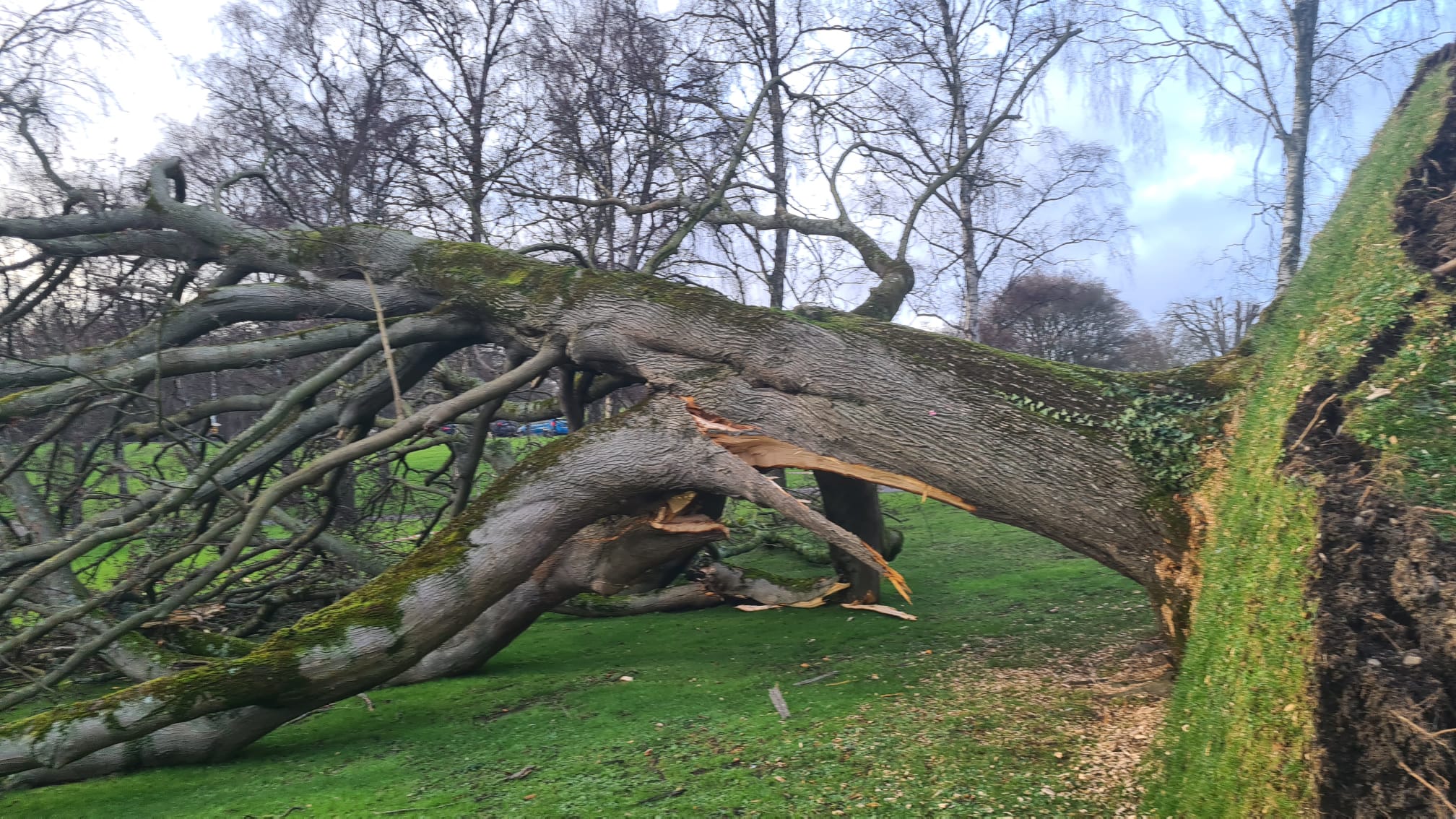
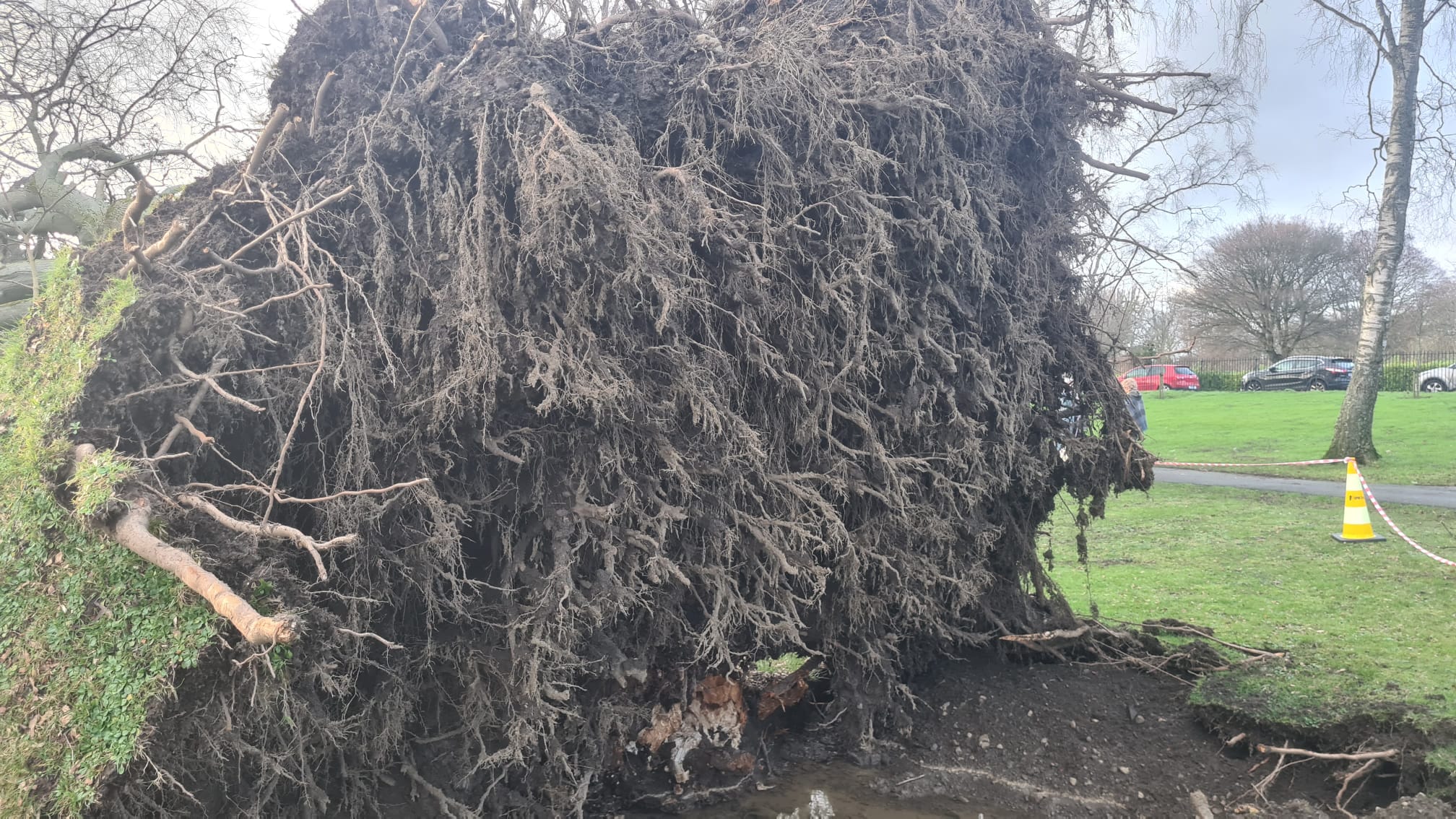
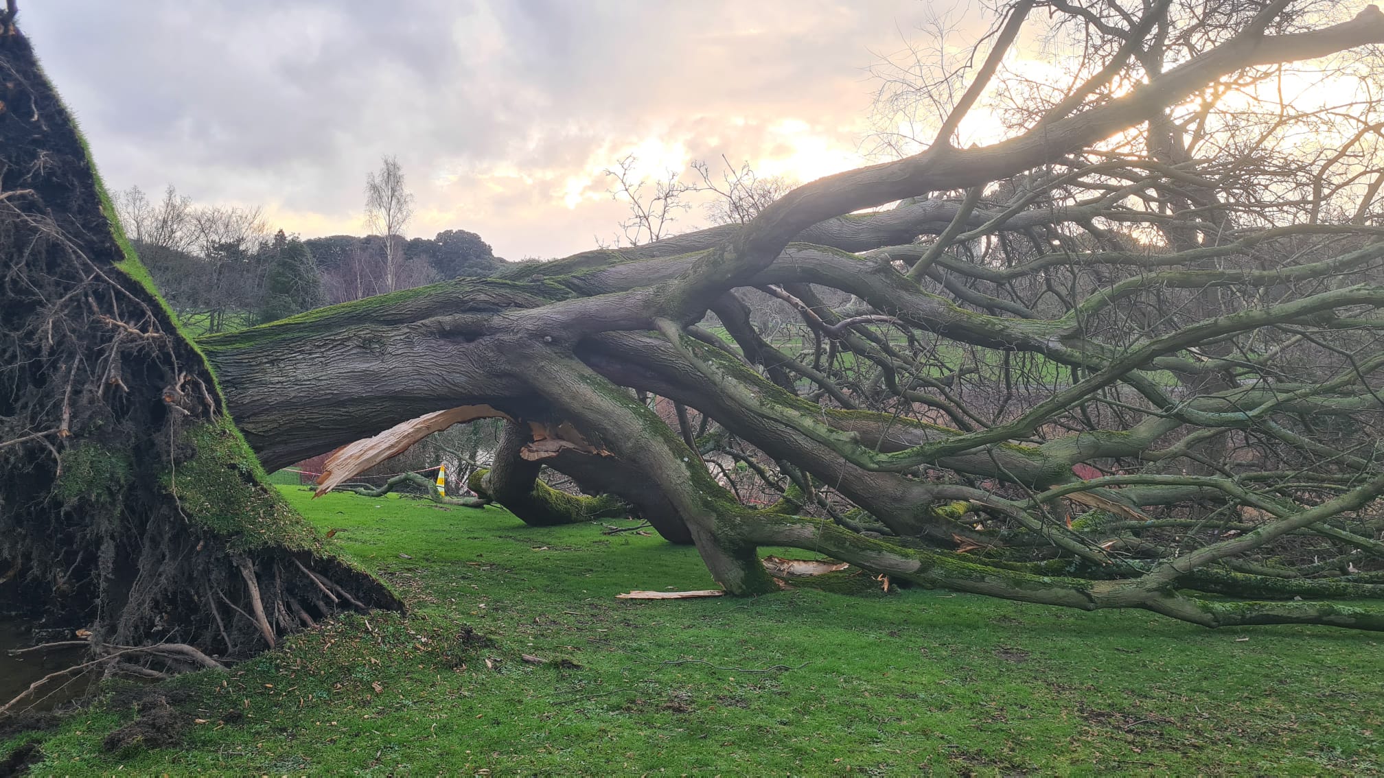
In pictures: An uprooted tree in Dublin
06:00 , Shaheena UddinRivers burst their banks, including the Slaney in Co Wexford and the Dodder in Dublin, with fallen trees reported across the island.
Cloudy and foggy start to Thursday
05:00 , Shaheena UddinA cloudy start to Thursday with some fog, this slow to clear in places 🌫️
— Met Office (@metoffice) January 28, 2026
Feeling chilly with rain and hill snow continuing in NE Scotland ❄️
By midday, showers in the far southwest will be replaced by heavy rain, spreading eastwards later and adding to ongoing flooding ⚠️ pic.twitter.com/fHHb4NE98D
Explainer: What was driving Storm Chandra?
04:00 , Shaheena UddinStorm Chandra was formed from a deepening Atlantic low that tracked eastwards, bringing in a vigorous fetch of moist air from the southwest, according to the Met Office.
As it neared the UK the system escalated, carrying unusually strong easterly winds to parts of Northern Ireland, as well as strong gusty winds to the Isles of Scilly, Cornwall and southwestern Wales, which had already suffered damage from Storm Goretti.
Storm Chandra also pushed persistent and heavy rainfall into parts of Dorset, Somerset and Devon. An Amber warning for rain reflected the worries around the expected rainfall accumulations.
Drivers urged to carry floodkits due to heavy rain
03:00 , Shaheena UddinThe Met Office have warned drivers and residents in affected areas to prepare a floodkit, to help in the event that their home, business or car becomes damaged.
It is not safe to drive or walk or swim through floodwater, avoid it where possible and if you are affected by fast flowing or deep water call 999 and wait for help.
Preparing a floodkit should include:
- Insurance documents and list of contact numbers
- Torch & spare batteries
- First aid kit and any prescription medicines
- Warm waterproof clothes and blankets
- Bottled water and snacks
- Battery or wind-up radio
- Supplies for looking after your baby or pet
Highest UK rainfall totals from Storm Chandra
02:00 , Shaheena UddinA number of sites exceeded 60 mm, with the wettest locations seeing over 110 mm of rain:
- White Barrow, Devon – 115.1 mmThe highest total recorded during Storm Chandra, with sustained heavy rainfall through the morning of 27 January.
- Katesbridge, County Down – 114.8 mmA remarkably high total for Northern Ireland, highlighting the storm's broad footprint. Katesbridge also appears frequently in the hourly high‑rainfall records, showing consistent heavy bursts.
- Banagher, Caugh Hill, Londonderry – 83.2 mmAnother significant total in Northern Ireland, illustrating how Chandra’s associated rainfall band pivoted northwards.
- Dartmoor Training Centre, Devon – 75.7 mm,
- Brookfield Farm, Devon – 73 mm,
- Princetown Prison, Devon – 68.2 mm,
- Bellever, Dartmoor – 67.6 mm,
- Glen Ample, Stirlingshire – 66.6 mm.
Storm Chandra map: Where heavy rain and flooding hit UK after ‘danger to life’ warning issued
01:00 , Shaheena UddinStorm Chandra has brought weather chaos this week with strong winds, heavy rain and snowbattering much of the UK, with the Met Office issuing further yellow warnings to Friday.
Read more:
Storm Chandra map: Where flooding hit today after ‘danger to life’ warning
Met Office shares tips for staying safe during flooding
00:00 , Shaheena UddinThe Met Office advises following these siz simple steps to protect your home or business:
- Check the flood advice in your area to know when and where flooding will happen
- Charge mobile phone devices
- Park your car outside the flood zone
- Prepare a flood kit to help you cope in the event of flooding to your home and business
- Store valuables up high, including electrical devices, important documents and furniture
- Turn off gas water and electricity supplies
Watch: 'Danger to life' warnings issued across UK and Ireland
Wednesday 28 January 2026 23:00 , Shaheena UddinFive tips for driving in fog
Wednesday 28 January 2026 22:00 , Shaheena UddinFog and low cloud is expected overnight, which could cause some difficult travel conditions.
RAC and National Highways have partnered with Met Office to share five tips for driving in fog:
1. Make sure you’re familiar with how to operate your front and rear fog lights
2. Do not use full beam lights, as the fog reflects the light back, reducing visibility even further
3. Follow the ‘two-second rule’ or even increase the gap to four seconds
4. Ensure the heater is set to windscreen de-misting and open all the vents
5. If visibility is very limited, wind down your windows at junction and crossroads
A married couple had to be rescued from their home by boat due to almost waist-high water
Wednesday 28 January 2026 21:45 , Shaheena UddinA married couple based in Antrim had to be rescued from their house by boat after flood water rose to almost waist-high.
David Leatherman and Jim Cunningham have since spoken about their frustrations in how the Department for Infrastructure (DFI) has handled the damage caused to their home by Storm Chandra.
Jim Cunningham told ITVX that the couple were "psychologically destroyed" by the damage to their house.
Speaking of the disaster Mr Leatherman said: "I came home and the water just was rising, and by 4PM, it was right up to our waists”, as reported by ITVX.
Mr Leatherman phoned the DFI and was told he would be put on a list. He then spotted two DFI staff walking up the street as the flood reached the telegraph pole there and asked them what they were planning to do about it.
The staff responded that they were trying to contact their boss but haven’t been able to get through to him and would come back in half and hour but they next showed up, according to Mr Leatherman.
Minister for Infrastructure (DfI) Liz Kimmins MLA met with the two men who were pulled to safety. She said to ITVX: "What happened yesterday in Riverside was "devastating" to all those who were impacted." She explained that the department received thousands of calls on Tuesday alone.
She added: “Our staff are working day and night, and we're trying to stretch our resources as far as possible, including deploying staff from different business areas within the department to try and support that.
"The pressure that we were feeling right across the north yesterday was really, really felt. Everyone was stretched trying to deal with what was coming at us from all different angles. That's not an excuse, I suppose it's just to say that's the reality of what we are dealing with on a very regular basis, and we have to make sure that we're targeting resources properly."
Met Office shares forecast map for Thursday
Wednesday 28 January 2026 21:30 , Shaheena UddinWill there be some 🌥️ or some more 🌧️ in the 4cast tomorrow? pic.twitter.com/OfB1kUSGlN
— Met Office (@metoffice) January 28, 2026
Further rain warnings issued for Ireland as Minister accuses forecasters of 'guarding' information
Wednesday 28 January 2026 21:00 , Shaheena UddinNew weather warnings for rain have been issued in Ireland, as communities hit by heavy flooding earlier in the week assess the damage.
Met Eireann has issued a Status Yellow rain warning for counties Dublin, Carlow, Kilkenny, Wexford, Wicklow, and Waterford which will be in effect all day Thursday.
A Yellow-level rain warning has also been issued by the Met Office for Northern Ireland, from midnight until 6pm on Friday.
Minister for Housing and Local Government James Browne said that information should not be “guarded” and he had asked Met Eireann to look at how they assess what level of weather warning is warranted.
He told South East Radio’s Morning Mix that Met Eireann needed to improve communications and said he was “really frustrated that some state agencies seem to think that it’s their duty to somehow withhold information”.
“We will be bringing Met Eireann in and say that, look, there needs to be an understanding here that information is not to be guarded, information is to be put out there and we need to do a much better job at communications,” he said.
“Also what we’ve asked Met Eireann to do is to look at how they bring these warnings – yellow, orange, red warnings – it’s based on a mathematical formula whereas in other countries they use the mathematical formula, but then they also make a judgment call and I there needs to be a greater use of that judgment call as well, I think in terms of being able to warn people of what is coming down the line.”
Labour’s climate spokesperson Ciaran Ahern responded to Mr Browne’s comments saying they were “extraordinary” and “ridiculous”.
“At a time when many areas across the country are flooding due to this Government’s failure to fund flooding defence systems that have been called for for years, this blatant attempt to distract and deflect must be called out,” he said.
“Storm Chandra must be a wake-up call for all of us but particularly those with a seat at the Cabinet table.”
In pictures: An uprooted tree in Dublin
Wednesday 28 January 2026 20:30 , Shaheena UddinRivers burst their banks, including the Slaney in Co Wexford and the Dodder in Dublin, with fallen trees reported across the island.
Storm Chandra sparks disruption across train network with GWR and ScotRail hit
Wednesday 28 January 2026 20:00 , Shaheena UddinTravel misery is set to continue for days for people in southwest England – with transport chaos continuing around the rest of the UK.
Following on from Storm Chandra, the Met Office has issued a Yellow weather warning for rain across Cornwall, Devon, Dorset and into Somerset and Wiltshire.
The Independent’s Travel correspondent, Simon Calder, reports:

Storm Chandra sparks disruption across train network with GWR and ScotRail hit
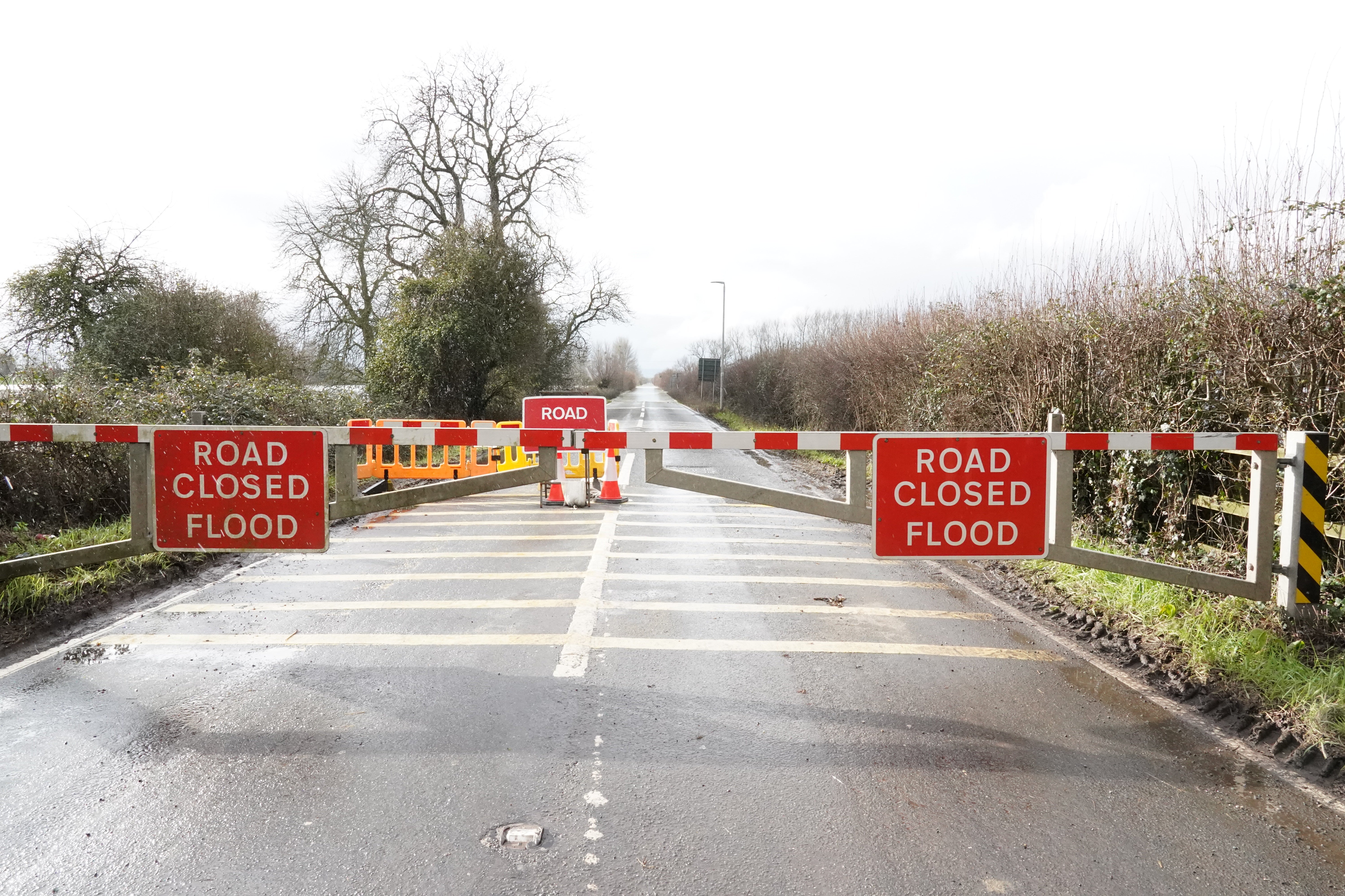
Road closures in Somerset due to flooding
Wednesday 28 January 2026 19:30 , Shaheena UddinSeveral roads have been closed in Somerset due to flooding:
- Devon - M5 - One lane closed and slow traffic due to emergency repairs and flooding on M5 Southbound from J28 A373 Honiton Road (Cullompton / Service Area) to J29 A30 Honiton Road (Exeter / Honiton).
- Podimore - A303 - One lane closed due to flooding on A303 Westbound from A37 (Podimore Roundabout, Podimore) to A3088 (Cartgate Roundabout, Stoke Sub Hamdon). Traffic is coping well.
- Burrowbridge - A361 New Road - A361 New Road both ways closed due to flooding between Stathe Road (Burrowbridge) and Cuts Road (East Lyng).
Retired couple fear 'scariest' floods in over a decade
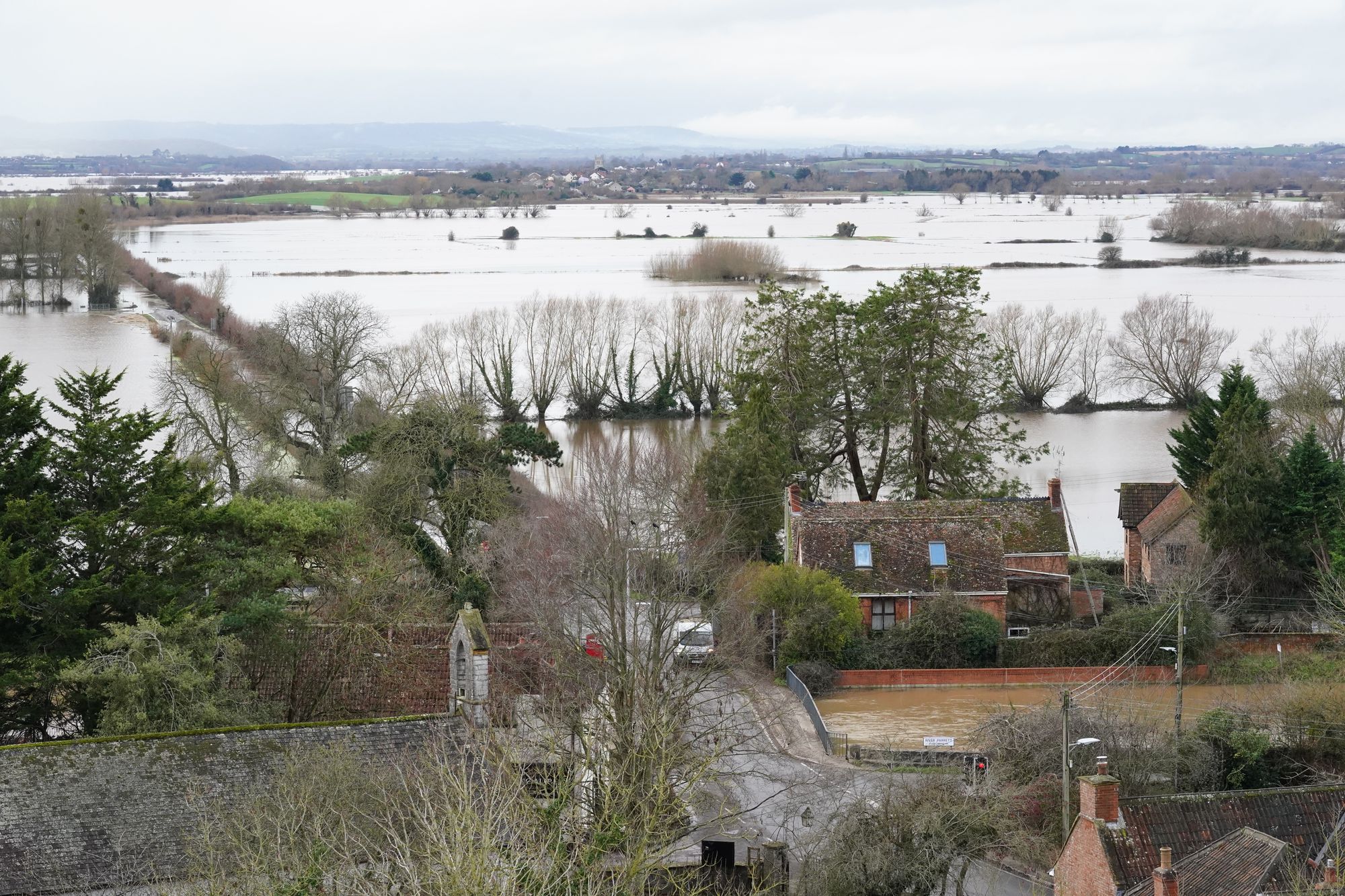
Wednesday 28 January 2026 19:00 , Shaheena UddinA retired couple based on the Somerset Levels, where a “major incident” was declared on Tuesday, fear heavy rainfall on Thursday could bring the worst flooding in over a decade.
Lesley and John Parker, who live in the village of Burrowbridge, Somerset, have installed flood defences around their home in the hopes of containing the water, which they worry will come “straight up through the floor”.
Mr and Mrs Parker said the conditions are the scariest they have seen since their home was devastated by flooding in 2014, when 3ft of water inside the house forced them to evacuate.
The couple said they have been mostly “left to (their) own devices”, and believe the Environment Agency has done “too little too late” to save their home of 14 years.
Mr Parker said: “The thing was, in 2014, the whole process was much slower, it was almost like slow motion.
“Whereas this has happened so fast that nothing has actually been set up yet.”
On Wednesday, the couple installed a flood barrier provided by their local rotary club and stuffed sandbags outside the entrances to their home.
A spokesman for the Environment Agency said: “Our incident response has been ahead of the curve – not behind it. Staff have been working hard 24/7 to protect people and property.”
A 'major incident' of flooding in Somerset
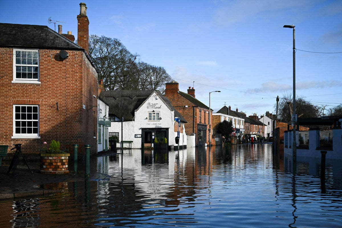
Wednesday 28 January 2026 18:30 , Shaheena UddinIn Somerset, a major incident was declared on Tuesday after Storm Chandra caused flooding to roads and properties.
Somerset Council said an estimated 50 properties had been affected by flooding across Ilminster, West Coker, Taunton, Mudford and West Camel.
Council leader Bill Revans said: “The weather forecast remains challenging so we will be working with colleagues in the emergency services to ensure we are prepared should the situation continue to deteriorate.”

What is causing all the wet weather?
Wednesday 28 January 2026 18:00 , Shaheena UddinWondering what's causing all the wet weather? pic.twitter.com/jxIfcFuRA3
— Met Office (@metoffice) January 28, 2026
Dorset council issues severe hazard alert after road blocked
Wednesday 28 January 2026 17:30 , Shaheena UddinDorset council have issued a severe hazard incident alert in West Parley, Bournemouth.
The A347 New Road is currently blocked both ways with queueing traffic after the River Stour bridge.
On Wednesday, a severe flood warning was issued for the Lower Stour at Iford Bridge Home Park, where residents were told to evacuate their properties “as soon as possible” and to pack an overnight bag with any essential items such as medications.
Staff from Bournemouth borough council and emergency services are onsite to assist residents. Residents were also advised to move family, pets and cars to safety and turn off gas, electricity and water if it is safe to do so.
River levels are forecasted to be higher than November 2024, peaking at 3.66m at approximately 2pm on Wednesday 28 January.
Environment Agency warns to 'stay vigilant' as flooding risk continues
Wednesday 28 January 2026 17:00 , Shaheena UddinThe Environment Agency has informed people to remain vigilant to the risk of flooding as further yellow rain warnings come into place as a result of Storm Chandra.
Weather conditions are forecasted to remain unsettled for Thursday and Friday, as the Met Office issued warnings across both days in the south of England and Northern Ireland on Friday.
An estimated 63 properties across England have been flooded, and almost 10,900 protected through Environment Agency action, a spokesman said.
On Wednesday, a severe flood warning was issued for the Lower Stour at Iford Bridge Home Park, where residents were told to evacuate their properties “as soon as possible”.
Chris Wilding, flood duty manager at the Environment Agency, said: “Our thoughts are with all those affected by Storm Chandra, including those whose homes and businesses have sadly been flooded.
“Significant river flooding impacts are probable in parts of the south west of England today. Further flooding impacts are also expected for parts of England on Thursday and into early Friday morning.
“Environment Agency teams are out on the ground, including in Somerset, to reduce the impact of flooding and support those communities affected.
“We urge people not to drive though flood water – it is often deeper than it looks and just 30cm of flowing water is enough to float your car.”
Yellow weather warning issued for Thursday
Wednesday 28 January 2026 16:30 , Shaheena UddinThe Met Office issued a yellow weather warning for rain to begin at noon on Thursday and continue until 3am on Friday.
The forecasters predict this further rain to lead to some travel disruption and intensify flooding in some areas. Spray and flooding on roads may make journey times longer, impacting bus and train services, as well as affecting some homes and businesses.
The national weather service said: “A band of rain will arrive across Cornwall on Thursday afternoon then move northeast across the warning area through the evening and clearing during early Friday.
“The rain is only likely to last for a few hours in any one location but will be at heavy at times. A further 10-15 mm of rain is expected fairly widely, but some locations, most likely in the south of the area, could see 20-25 mm.
“The likelihood of impacts from these rainfall amounts is higher than normal due to saturated ground and ongoing flooding following Storm Chandra.”
UK five day weather forecast
Wednesday 28 January 2026 16:15 , Shaheena UddinThe Met Office has forecasted that the rest of this week will remain rather cloudy, with possible showers predicted on Thursday.
Wednesday evening:
Low cloud and fog forming across many eastern and central areas overnight, with some patchy rain possible where the cloud is thickest. Elsewhere, a few clear spells and some patchy frost are likely, although occasional showers may affect the southwest.
Thursday:
Rather cloudy and breezy with some rain and hill snow lingering in the northeast, whilst showers give way to more persistent rain towards the southwest. Some brighter breaks developing elsewhere.
Outlook for Friday and the weekend:
Friday looks unsettled with brisk winds. Rather cloudy skies giving outbreaks of rain for many. Brighter and becoming less breezy for most over the weekend, albeit with scattered showers still.
Watch: River Slaney burst its banks as Storm Chandra batters Ireland
Wednesday 28 January 2026 16:00 , Shaheena UddinFurther rain warnings issued for Ireland as clean up under way at flood-hit town
Wednesday 28 January 2026 15:41 , Holly EvansNew rain warnings have been issued as communities hit by heavy flooding earlier in the week assess the damage.
Met Eireann has issued a Status Yellow rain warning for counties Dublin, Carlow, Kilkenny, Wexford, Wicklow, and Waterford which will be in effect all day Thursday.
The Irish forecaster warned that heavy rain, combined with saturated grounds and high river levels, could lead to more flooding.
A Yellow-level rain warning has also been issued by the Met Office for Northern Ireland, from midnight until 6pm on Friday.
The warnings come as the clean up begins in areas hit by heavy flooding earlier in the week caused by Storm Chandra.
Heavy winds and torrential rain on Tuesday caused significant disruption across the island of Ireland, including power outages, flight cancellations and 300 school closures in Northern Ireland.
Rivers burst their banks, including the Slaney in Co Wexford and the Dodder in Dublin, with fallen trees reported across the island.
Watch: 'Danger to life' warnings issued across UK and Ireland
Wednesday 28 January 2026 15:22 , Holly EvansMore heavy rain forecasted to hit Northern Ireland
Wednesday 28 January 2026 15:04 , Holly EvansThe Met Office have warned that further heavy rain is forecast to hit Northern Ireland in the coming days.
A yellow warning for rain in place from midnight until Friday evening, with any rain again falling on saturated ground.
The wettest conditions are likely to be over Antrim and Down, with potential for many areas to see 10-25 mm of rainfall, with 40-60 mm over some hills.
⚠️ Yellow weather warning issued ⚠️
— Met Office (@metoffice) January 28, 2026
Further rain across Northern Ireland falling on already saturated ground
Friday 00:00 – 18:00
Latest info 👉 https://t.co/QwDLMfRBfs
Stay #WeatherAware⚠️ pic.twitter.com/pdqAax2BbW
'Nobody seems to do anything about it,' says Dorset resident
Wednesday 28 January 2026 14:37 , Holly EvansAnn Mallett, who has gone to stay with her family after being evacuated from the Iford Bridge Home Park, near Christchurch in Dorset, said flood alleviation measures needed installing at the park after the latest incident.
“It’s obviously going to get worse every year and nobody seems to do anything about it,” she told the Press Association.
“We are OK because we are over to our sons to stay, but some people don’t have that.
“It’s just a flipping nuisance really.
“They have switched the electricity off and I did a big shop about a week ago. I should not have done really.”
Multiple ferry sailings cancelled in the Channel
Wednesday 28 January 2026 14:19 , Holly EvansIn the English Channel, Brittany Ferries has cancelled Wednesday sailings from Poole both Cherbourg and Bilbao in Spain.
DFDS Ferries has cancelled multiple services linking Jersey with Portsmouth and St-Malo, but an additional round-trip from the Channel Island to the French port is scheduled for Thursday.
Caledonian MacBrayne ferries in the Western Isles of Scotland continue to be disrupted “due to forecast strong winds and sea swell”.
Affected routes include the link from Oban to Barra. Calmac warns: “Sailings are at a heightened risk of disruption or cancellation at short notice.”
Dorset resident evacuated from home experienced flooding in 2013
Wednesday 28 January 2026 14:10 , Holly EvansResident Martin Sadler, who was among those evacuated from the Iford Bridge Home Park, near Christchurch in Dorset, told the Press Association: “I was there in 2013 and my home was flooded then.
“Subsequent to that the homes were raised by about 65cms.
“I feel quite safe actually now that the home is safe from flooding.
“I think they are turning the electricity off, and so that’s a bit difficult to be comfortable without that.
“I stayed there until it got a bit risky and I left. I left before I got wet feet.”
Lorry driver dies after crashing into river in Hampshire
Wednesday 28 January 2026 13:58 , Holly EvansA lorry driver died in the New Forest after crashing into a river on Tuesday in the aftermath of Storm Chandra.
Hampshire Police said a man, who was in his 60s, was pronounced dead at the scene of the incident in North Gorley.
“We were called just after 1pm on Tuesday to a report that a lorry had gone into a river off Ringwood Road in North Gorley,” a force spokesman said.
“Sadly the driver, a man in his 60s, was pronounced deceased at the scene.
“Inquiries are ongoing to establish the circumstances surrounding his death.”
Full list of UK schools closed today as Storm Chandra brings ‘extensive’ flooding and ice warnings
Wednesday 28 January 2026 13:45 , Holly EvansHundreds of schools across the UK remain closed today as Storm Chandra continues to bring dangerous conditions and nearly 100 flood warnings.
Over 350 schools are now confirmed to be closed in Northern Ireland, while dozens remain shut across the South West of England.
Northern Ireland is experiencing severe weather, with yesterday’s amber warning being replaced with an ice warning that covers all regions.
Read the full article here:
Full list of UK schools closed today as Storm Chandra brings flooding and ice warning