The Met Office has issued a fresh “risk to life” weather warning for heavy snow as parts of the UK brace for blizzard conditions.
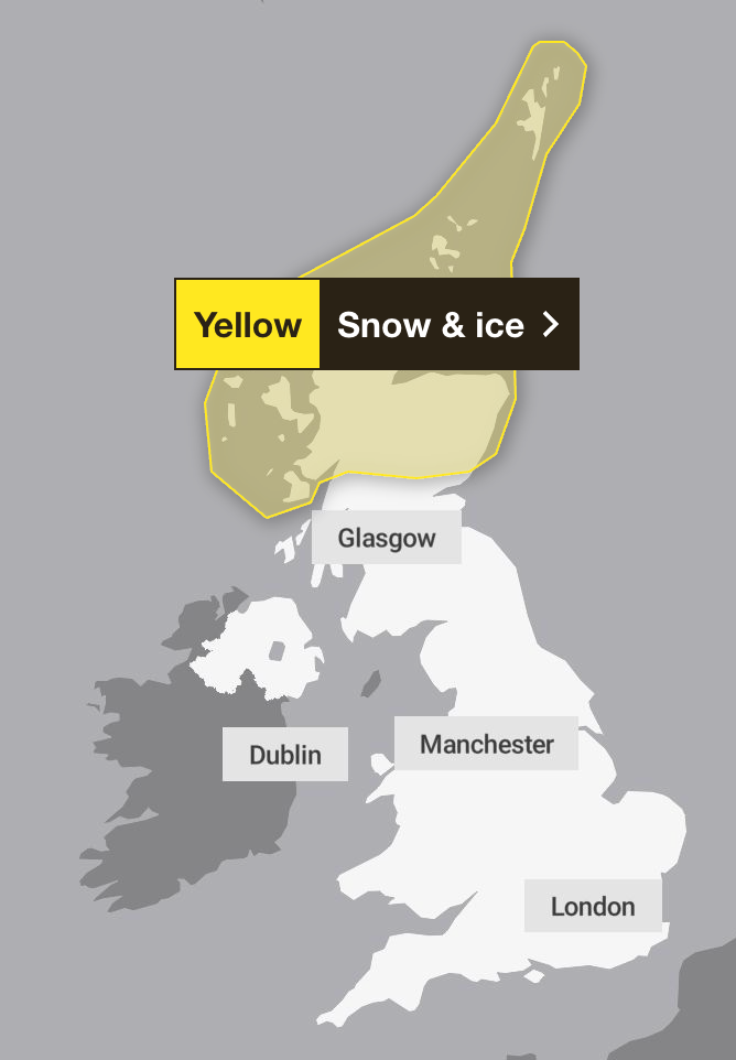
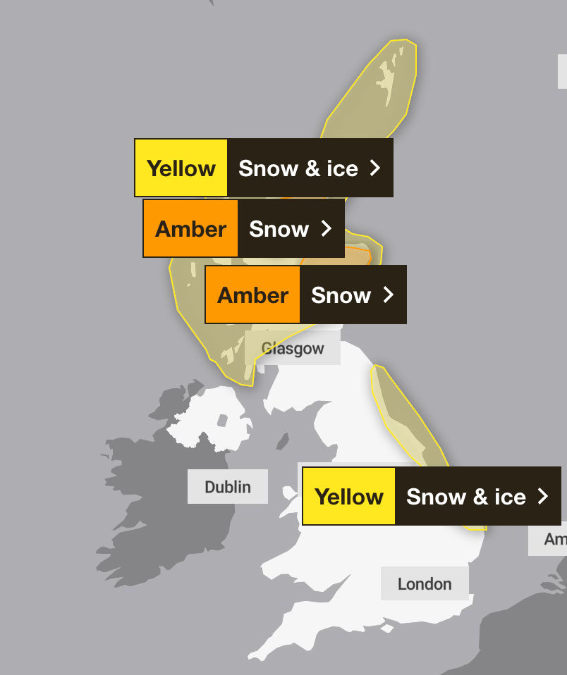
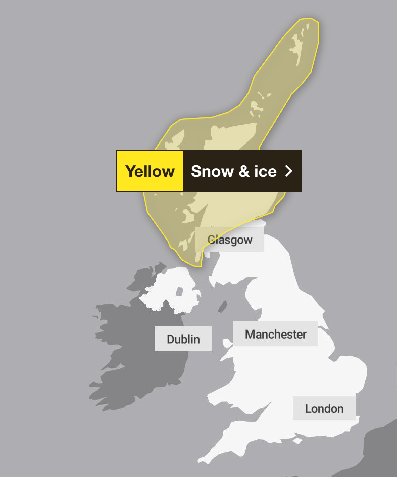
The yellow warning for snow and ice covering northern parts of Scotland is in force from 6am on Thursday, 1 January to 11.59pm on Friday, 2 January.
The weather agency warns that frequent and heavy snow showers in that area may lead to travel disruption, with up to 30cm of snow possible on the highest routes and hills.
The warning covers the entirety of northern Scotland, with Central, Tayside and Fife, Grampian, Highlands and Eilean Siar, Orkney and Shetland, and Strathclyde the regions and local authorities affected.
The forecaster predicts 2-5cm could be lying by Thursday evening, with 10cm accumulating by Friday morning, while up to 20cm could build up above 200 metres.
Met Office deputy chief forecaster Mark Sidaway added: “It certainly looks like we are in for a taste of ‘winter’ as we welcome in the New Year, initially in the north, but more widely across the UK for the first week of 2026.
“Arctic air and strong northerly winds will bring cold or very cold conditions to all parts of the UK, and it will feel especially cold in the strong winds. Widespread and locally severe frosts are expected, along with the first snow of the winter for many.
“A yellow warning for snow and ice has been issued for northern Scotland on New Year’s Day and beyond, where frequent and heavy snow showers may lead to some travel disruption.
“These colder conditions and wintry hazards – snow, ice and strong winds – will develop more widely as we enter the New Year.”
Further weather warnings for snow in parts of Scotland have now been upgraded from yellow to amber by the Met Office. The warnings cover northern and north-east Scotland, with frequent and prolonged snow showers expected between noon on Friday until noon on Saturday.
The forecaster said vehicles could become stranded on roads, and delays and cancellations for trains and flights are likely. There is also a chance that rural communities could become cut off, while power cuts are also likely, the Met Office said.
Meanwhile, a yellow warning for snow and ice has been issued for large parts of England and Wales between midnight and noon on Friday, including Chester and Greater Manchester down to London and Kent. Up to 5cm of snow could blanket some areas, especially on higher ground in parts of North Wales and north-west England.
Separate yellow warnings are in place for Northern Ireland between midnight and 10am on Friday.
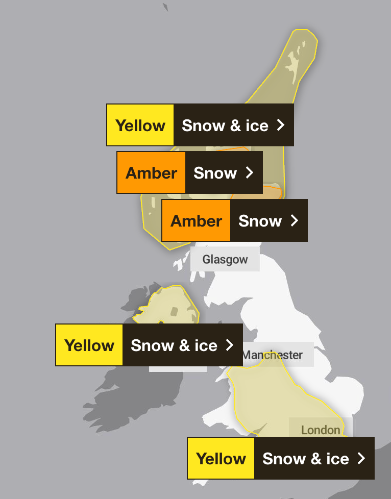
On Saturday, there is another snow and ice warning for northern Scotland, which lasts from midnight Friday until midnight Sunday. Meanwhile, a snow and ice warning covering parts of north east England comes into force from midnight Friday until midnight Saturday.
People have been urged to prepare for longer journey times by road, and on bus and train services. The forecaster has also warned of injuries due to slips and falls on icy surfaces, which will develop quickly as sleet and snow clears.
A Met Office spokeswoman said: “This warning highlights the risk of disruptive snow showers and icy surfaces, particularly in northern and eastern areas, with impacts on travel and potential hazards for the public.
“We expect this cold spell to persist into the weekend and on into next week, with further warnings possible as temperatures remain well below average and snow showers continue in places.”
The UK Health Security Agency (UKHSA) has also issued an amber cold health alert warning of disruption to the health sector, covering the north east and north west of England until 5 January. All other regions in England will be under a yellow alert for this period.
Dr Agostinho Sousa, head of extreme events and health Protection at UKHSA, said: “As the colder weather sets in it is vital to check in on friends, family and neighbours that are most vulnerable.
“The forecasted temperatures can have a serious impact on the health of some people, leading to increased risk of heart attacks, strokes and chest infections, particularly for individuals over the age of 65 and those with pre-existing health conditions.”
The UKHSA warned there will likely be an increase in demand for health services across the regions. With even younger people potentially impacted by the weather, it said that a drop in temperature leads to more risks for vulnerable people, while a fall in places like hospitals and care homes could bring it below the levels recommended for assessing health risks.
It also warned of staffing issues due to external factors such as travel delays and said other sectors, such as transport and energy, could start to be affected by the weather.
Met Office forecast for the UK from Thursday 1 January
Thursday
Patchy rain and hill snow clear southwards through the day, followed by sunny spells from the north. Northern Scotland sees frequent snow showers with significant accumulations over the hills. Strong to gale-force winds affect northern and eastern areas. Cold everywhere.
Thursday night
Clear skies for many with an early frost. Snow showers persist in the north, while sleet and snow spread south across Northern Ireland into parts of England and Wales later.
Friday
Patchy rain, sleet, and snow move south across England and Wales on Friday morning. Snow showers in the north are becoming more widespread, especially in areas exposed to the brisk northerly wind.
Outlook for Saturday to Monday
Often cold and sunny with severe overnight frosts. Snow showers continue to affect many areas exposed to the brisk northerly wind. Risk of more organised sleet and snow at times.
Call to roll out Tasers across PSNI as attacks on officers spiral
Britain to be blanketed with snow and ice for new year as Met Office issues warnings
Britain’s longest missing person case: What happened to Mary Flanagan?
8 best electric heaters that will keep your home warm, tested by an expert
Best electric blankets and heated throws to keep you warm and toasty, tried and tested
How much it actually costs to run a dehumidifier, according to experts