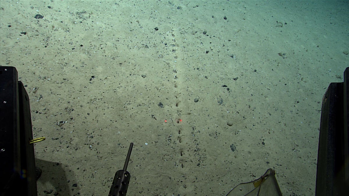
Scientists have stumbled upon a series of seemingly human-made organised holes on the Atlantic Ocean floor whose origins remain a mystery.
The “perfectly aligned” holes were discovered on 23 July but have been previously reported from the region, researchers studying the ocean floor aboard the NOAA ship Okeanos Explorer said.
Now the NOAA Ocean Exploration agency is inviting members of the public to offer their theories as to how these holes were formed.
“On Saturday’s Okeanos dive, we observed several of these sublinear sets of holes in the sediment. These holes have been previously reported from the region, but their origin remains a mystery,” the agency, which is dedicated to exploring the global ocean, noted in a Facebook post.
“While they look almost human-made, the little piles of sediment around the holes make them seem like they were excavated by... something,” said the federal organisation.
In Saturday’s dive, scientists probed the ocean floor at depths of about 3km while visiting the summit of an underwater volcano north of the Azores – an autonomous region of Portugal in the mid-Atlantic.
They used a remotely operated camera to record the mysterious holes.
The discovery was made during the Okeanos vessel’s Voyage to the Ridge 2022 expedition in which scientists are exploring and mapping the “poorly understood deepwater areas of the Charlie-Gibbs Fracture Zone, Mid-Atlantic Ridge, and Azores Plateau.”
“During Dive 04 of the second Voyage to the Ridge 2022 expedition, we observed several of these sublinear sets of holes in the sediment,” NOAA Ocean Exploration said.
“What’s your hypothesis,” the federal organisation asked in the Facebook post, sharing images of the discovery and inviting the public to offer their theories.
The area under study in the expedition includes the Mid-Atlantic Ridge – a site of frequent earthquakes – stretching over 16,000km from north to south.
It is considered “the longest mountain range in the world and one of the most prominent geological features on Earth”, according to NOAA.
The majority of the ridge, scientists say, sits underwater and remains largely unexplored.
Scientists part of the exploration mission will conduct mapping operations and dives using a remotely operated vehicle system to explore the Mid-Atlantic Ridge (north of the Azores) and the Azores Plateau.
They say the mission will yield data to understand the diversity and extent of deep-sea coral and sponge communities along the Mid-Atlantic Ridge, Azores Plateau, and Charlie-Gibbs Fracture Zone.
“While recent research has significantly contributed to our understanding and appreciation of corals and sponges, there is still a great deal to learn about their distribution, diversity, reproduction, and resilience, particularly in the unexplored and poorly understood deepwater areas where we will be exploring,” NOAA noted in a statement.
Next month, their mapping operations will focus on the Azores Plateau and the Mid-Atlantic Ridge – south of the Azores – they said.
“During dives, we expect to explore deep-sea coral and sponge habitats, potential hydrothermal vent and extinct polymetallic sulfide systems, fracture and rift zones, and the water column,” NOAA said.


