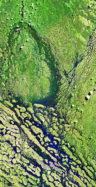
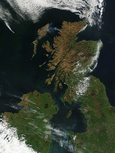
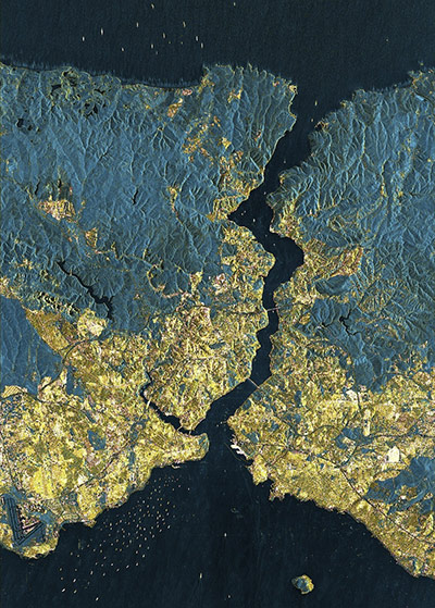
Seasonal floods affected thousands of people in Angola and Namibia during the rainy season that stretched into April. Floodwaters finally receded in May, but not before an estimated 260,000 residents had been affected. This image taken on 13 May uses a combination of shortwave infrared, near infrared, and red light that better distinguishes between water and land better than natural-colour images. Vegetation appears bright green, and water appears bright blue. Thin white lines show embankmentsPhotograph: ALI/EO-1/NASASmoke from wildfires in Northern Ireland and Scotland are seen in this photograph taken on 2 May. The Moderate Resolution Imaging Spectroradiometer on Nasa's Terra satellite acquired the image, and the fires detected by the sensor were marked in red at sourcePhotograph: NASA/NASAWith some 15 million inhabitants, Istanbul is one of the world's megacities. In this detailed view of the city from more than 500km up, the airport can be seen to the west – the taxiways and runways reflect the radar signals away from the satellite, causing the asphalt surfaces to appear as black lines. Areas of dense housing appear in yellow. The urbanisation snakes along the Bosphorus right down to the Black Sea. In the city itself, only a few areas remain undeveloped and are shown in green. This is the case on the headland where the Golden Horn, an inlet, extends into the European part. Having an exclusive panoramic view of the city and few neighbours, this is where the Topkapi Palace, the former residence and seat of government of the Sultans, is locatedPhotograph: TerraSAR-X/ DLR
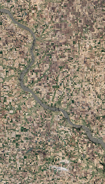
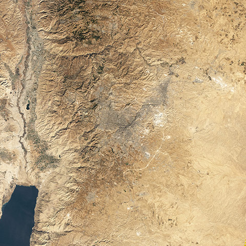
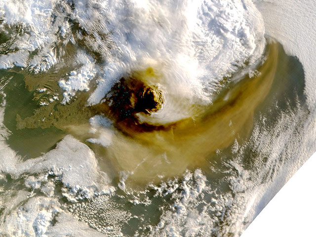
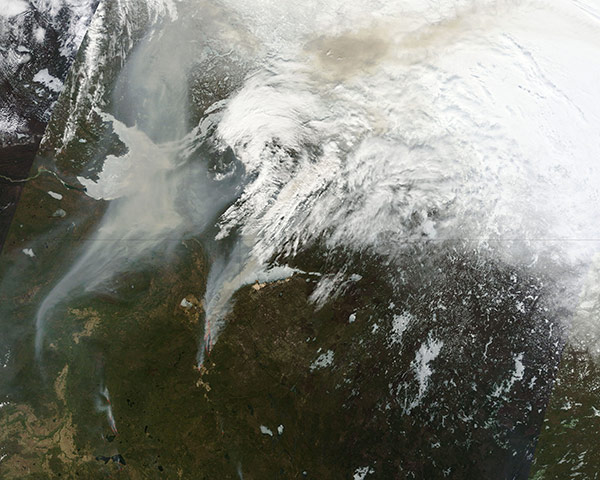
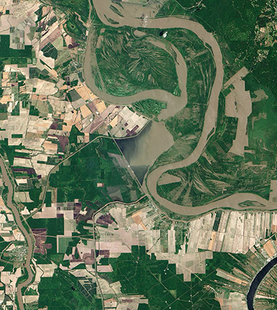
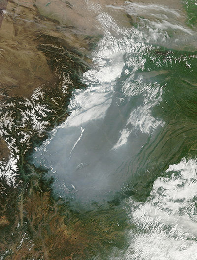
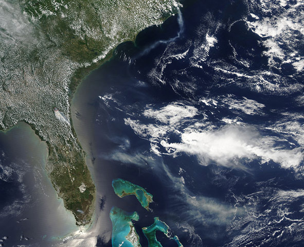
On 27 April 2011, a devastating tornado tore through Tuscaloosa, Alabama. It caused more than 1,000 injuries and at least 65 deaths across several towns and cities, the highest number of fatalities from a single tornado in the United States since 1955. The storm had winds of 190mph (310kph) and left a path of debris running south-west to north-east, shown in this image, taken on 2 May. The tan-toned, debris-filled path passes through the centre of town, affecting both commercial and residential properties. Running roughly parallel to the tornado track is a contrail from a planePhotograph: ALI/EO-1/NASAA large chunk of the massive iceberg (centre) that broke off Greenland's Petermann Glacier in August 2010 is featured floating in the Labrador Sea off the eastern coast of Labrador in this image, acquired on 4 May 2011. More than 1,000 icebergs floe off southern Labrador and northern Newfoundland from late May to late June, earning the area the nickname 'Iceberg Alley'. Ice floes (top) are visible drifting southwards in the sea. White swirls indicate drift of the small pieces of ice in response to ocean vortexes, or 'eddies', and are an expression of the ocean surface currentsPhotograph: MERIS/ESAThe space shuttle Endeavour on launch pad 39A at Nasa's Kennedy Space Center, Florida, waiting for launch to the International Space StationPhotograph: Geoeye/EPAA tributary of the Missouri River, the James River flows generally southward through the Dakotas. In early May 2011, the James, like other rivers in the U.S. Midwest, was flooded. image of the river passing through Jamesville, South Dakota, on May 1, 2011..River water in this image appears charcoal gray with an iridescent sheen. Although the river has not spilled over its banks, it fills the river valley completely. The river’s regular channel is the narrow, serpentine strip that meanders through the river valley. On either side of the river, agricultural fields create a patchwork of green and beige..Jamesville lies between Scotland and Yankton, two other South Dakota towns near the river. The Advanced Hydrological Prediction Service (AHPS) of the U.S. National Weather Service monitors water levels in the James River at both sites. Three days after ALI acquired this image, the AHPS reported that the James River remained at major flood stage in both Scotland and Yankton.Photograph: ALI/EO-1/NASAAbout 9,000 years ago, a settlement was founded in an area of rolling hills between the fertile Jordan River valley to the west and desert in the east. Along the banks of the Wadi Amman and its tributaries, this settlement has alternately flourished and declined, but has remained continuously inhabited to the present day. The city forms a rough V shape of grey. West of the city, the terrain is more rugged, with small valleys extending toward the Jordan River. Part of the Dead Sea appears south-west of Amman, and agricultural fields in the Jordan River valley appear west of town. Limestone and chert are good for holding water in aquifers, making them a valuable resource to the country. Less than 5% of Jordan’s land is arable, and just over 1% supports permanent crops. Fresh water is scarce, and drought and desertification pose perennial threatsPhotograph: Landsat 5/NASAGrimsvotn, one of Iceland's most active volcanos, started erupting on 22 May. The volcano, situated near the centre of the Vatnajökull ice cap in central Iceland, last erupted in 2004Photograph: GSFC/Jeff Schmaltz/MODIS/NASANumerous lakes dot the otherwise arid landscape of the Tibetan plateau. One of those lakes is Ayakum, near the northern boundary of the plateau, to the south-east of the Kunlun Mountains. While many of the small glacier- and snowmelt-fed streams on the plateau give rise to major south-east Asian rivers (including the Mekong and Yangtze), some empty into saline lakes such as Lake Ayakum. This astronaut photograph highlights two river deltas formed along its south-western shorelinePhotograph: ISS/NASAThis Nasa satellite image obtained on 25 May, 2011, shows an infrared image (centre) of a pattern of streets and houses in the buried ancient city of Tanis, Egypt. Seventeen lost pyramids and more than 1,000 tombs have been uncovered in a satellite survey of Egypt. Researchers led by US archaeologist Sarah Parcack at the University of Alabama have also located more than 3,000 ancient settlements in the area after studying images produced by a state-of-the-art infrared technique which allowed them to clearly see the ruins undergroundPhotograph: HO/AFPDust plumes blew off the Argentina coast and over the Atlantic Ocean on 23 May, 2011. Dust plumes arise from discrete source points near the coast, and blow fairly uniformly toward the east-northeast. Some of the long, thin plumes coalesce into a large veil of dust north-east of the city of Cabo Blanco. A few clouds float overhead, casting their shadows onto the land and water surfaces below. Although the presence of dust storms might suggest dry conditions, the dust plumes blowing off Argentina in late May 2011 appeared less severe than dust activity occurring in that region in 2009 and 2010. In early May 2011, the Foreign Agricultural Service reported that Argentina was entering its autumn season with a good supply of moisturePhotograph: MODIS/Aqua/NASAOn 16 May, 2011, tan and grey smoke spread hundreds of kilometres across Alberta, Saskatchewan, and the Northwest Territories in Canada. At 10am, the Alberta government reported 116 fires burning in the province, 34 of them out of control. The following day, the total number of fires had dropped to 100, and the number of uncontrolled fires had dropped to 22. But four new fires had started to burn out of control. Strong winds fanned the fires on May 15 and 16, sending thick plumes of smoke to the north. The fires forced some energy and transportation companies to suspend operations, reported CBC News. Multiple oil and gas companies suspended drilling and moved their employees to safety. Oil transport was also hampered by a shutdown of rail service and a pipeline closure. Meanwhile, fires near Lesser Slave Lake destroyed 40% of the nearby town on 15 May, including hundreds of homes and businesses and the town hallPhotograph: MODIS/Terra/NASAPart of the Morganza Spillway, seen at top centre in this satellite image, has been opened to take pressure off the Mississippi River. The floodgates were opened for the first time in nearly 40 years to lower the crest of the flooding river. Heavy rains have left the ground saturated, rivers swollen, and have caused widespread flooding in Louisiana, Mississippi, Missouri, Illinois, Kentucky, Tennessee, and ArkansasPhotograph: ALI/EO-1/NASAHaze hovered over China's Sichuan basin on 6 May, 2011. The dull grey haze contrasts with bright white clouds and lingering snowpack on nearby mountains. Along the basin's south-western margin, haze creeps into valleys, colouring them dingy gray. The haze likely results from urban and industrial pollutionPhotograph: MODIS/Terra/NASAThe Paraná River is South America’s second largest, and the river and its tributaries are important transportation routes for landlocked cities in Argentina, Paraguay, Bolivia, and Brazil. This astronaut photograph shows a 29 kilometre (18 mile) stretch of the Paraná, downstream of the small city of Goya, Argentina (just off the top left of the image). The Paraná River ranges up to 3km wide along the reach illustrated in this image. The main channel is deep enough to allow smaller ocean-going ships to pass north to the capital city of Asunción, Paraguay. The Paraná floodplain occupies the entire image; it is so wide—18 km (11m) in this view—that its banks are not visible Photograph: ISSS/NASAThe Aurora-Bodie volcanic field in Nevada includes a series of small lava flows and scoria (cinder) cones that range in age from about 100,000 years (late Pleistocene) to more than 15m years oldPhotograph: Digital Globe/NASAFires burning in south-eastern Georgia and eastern North Carolina caught the eye of Nasa's Aqua satellite as it passed overhead on 9 May. A long plume of smoke (top of the image) from the Pains Bay fire in Dare County, NC extends south-southwest over the Atlantic Ocean. The fire was likely caused by lightning strikes in the wetlands near of Stumpy Point. Farther south, the Honey Prairie fire (bottom of image) continues to rage in the Okefenokee Swamp, south-eastern Georgia. Thick smoke and ash continued to affect several counties in south-eastern Georgia and north-eastern Florida. When this image was captured, winds had shifted to the south-east, blowing the thick smoke into north-eastern Florida, including JacksonvillePhotograph: MODIS/Aqua/NASARun-off from heavy rains, combined with wave action along the coast, increased the turbidity of New Zealand's waters in May. The volume of sediment in the water hints at rough seas. Cook Strait, the narrow strip of water separating the North and South Islands of New Zealand, has a reputation for being among the world's roughest stretches of water. The islands lie within the 'Roaring Forties', a belt of winds that circles the globe around 40 degrees south. The westerlies hit the islands side on and run into the mountain ranges. Cook Strait is the only opening for the winds, so the channel becomes something of a wind tunnel. Strong winds produce high waves, and they erode the shore as shown in the image. However, sediment may not be causing all of the colour. The waters around New Zealand are rich in nutrients, so it is likely that phytoplankton are contributing to some of the fanciful swirls in the imagePhotograph: MODIS/Aqua/NASA
Sign up to read this article
Read news from 100’s of titles, curated specifically for you.