Get all your news in one place.
100's of premium titles.
One app.
Start reading
The Times of India
The Times of India
World
TOI World Desk

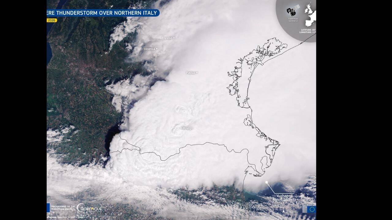
Satellite captures striking V-shaped thunderstorm over Northern Italy linked to severe weather

A striking satellite image has revealed the full scale of a powerful thunderstorm that swept across northern Italy on 21 July, leaving behind a cloud formation that immediately caught the attention of weather specialists. Seen from above, the storm displayed a pronounced V-shaped pattern stretching across the Po Valley towards the Adriatic Sea, a feature that is often linked with particularly intense convective systems. While dramatic in appearance, the shape also offers valuable clues about the processes taking place high within the storm. The image, recorded by the Copernicus Sentinel-2 mission, provides a detailed snapshot of an event that affected several parts of the Veneto region after developing during the early hours of the day. Meteorologists noted that the distinctive structure reflected strong upper-level winds interacting with rapidly rising thunderclouds, creating an organised storm capable of producing intense rainfall, damaging gusts, hail and frequent lightning across affected areas before gradually weakening later in the day.

Why the V-Shaped thunderstorm over Northern Italy is a sign of severe weather

Get breaking news anytime, anywhere. Download the TOI app now!

From the ground, thunderstorms usually appear as towering masses of dark cloud. Viewed from orbit, however, some reveal structures that tell meteorologists a great deal about their strength. In this case, the cloud top spread into a broad V, a pattern created when vigorous upward air currents push the storm to great heights before powerful upper-level winds split the cloud and divert it around its summit.

According to the European Union's Copernicus Earth Observation programme, that distinctive signature is more than a visual curiosity. It is commonly associated with storms capable of producing severe weather, including damaging straight-line winds, large hailstones and bursts of exceptionally heavy rain. The cloud pattern reflects the energy contained within the storm rather than simply its size, making it an important indicator for scientists studying violent convective weather.

How Arctic air triggered the powerful thunderstorm over Northern Italy

The atmospheric conditions over northern Italy had been building towards instability. A period of hot weather had left the lower atmosphere warm and rich in moisture, creating an environment ready to fuel thunderstorm growth if cooler air arrived.

Reportedly, as a fresh Arctic air mass advanced into the Mediterranean region, it encountered this warmer air over the Po Valley. The sharp temperature difference increased atmospheric instability, allowing warm air to rise rapidly and feed the developing storm. Once that process began, the thunderstorm intensified quickly, drawing energy from the contrast between the two air masses.

These ingredients are well known in meteorology, yet their combination can produce very different outcomes depending on timing, moisture levels and wind conditions higher in the atmosphere. On this occasion, the result was a particularly organised and powerful storm system.

Areas hit by the Northern Italy thunderstorm and the severe weather it brought

The thunderstorm took shape during the early hours of 21 July before moving across several provinces in northern Italy. Vicenza, Padua, Rovigo and Treviso were among the areas that experienced the strongest impacts as the system evolved.

As per the European Union, storms of this type can bring several hazards within a relatively short period. Intense rainfall may overwhelm drainage systems, while strong downdrafts are capable of generating destructive wind gusts over wide areas. Large hail is another common feature of highly organised convective storms, especially when powerful updraughts are able to keep ice particles suspended long enough for them to grow before falling to the ground.

Although satellite imagery does not directly record these surface impacts, it helps place local weather reports into a broader context by showing how the storm developed and expanded across the region.

How Copernicus Sentinel-2 satellites help scientists monitor severe thunderstorms

The Copernicus Sentinel-2 satellites are widely recognised for monitoring land, vegetation and environmental change, yet they also provide valuable observations of large weather systems when cloud conditions permit. High-resolution imagery allows scientists to examine the structure of storm tops, revealing details that are difficult to appreciate using ground observations alone.

Features such as V-shaped cloud signatures offer insight into the behaviour of powerful thunderstorms and improve understanding of how these systems evolve. Combined with conventional meteorological observations, satellite images contribute to ongoing research into severe convective weather and support efforts to monitor extreme events that are becoming increasingly frequent across parts of Europe.

Sign up to read this article
Read news from 100's of titles, curated specifically for you.
Already a member? Sign in here
Related Stories
Top stories on inkl right now
One subscription that gives you access to news from hundreds of sites
Already a member? Sign in here
Our Picks
Fourteen days free
Download the app
One app. One membership.
100+ trusted global sources.