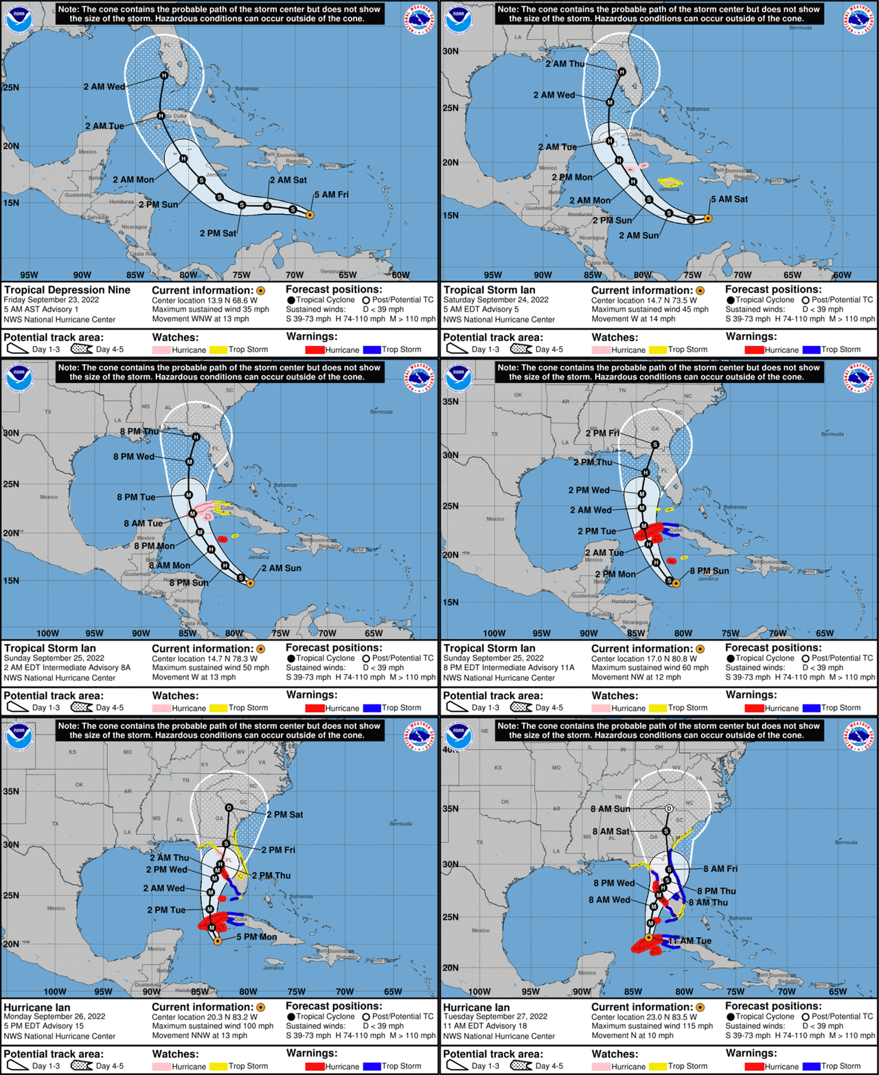
The "cone of uncertainty" is the tool forecasters use to illustrate a hurricane's likely path — and that title has been particularly apt for Hurricane Ian, whose predicted track has fluctuated by hundreds of miles as it developed into a dangerous storm.
The National Hurricane Center's initial track saw Ian likely hitting Florida far south of Tampa Bay. But that was Friday. Over the weekend, Ian's predicted path shifted briefly to Tampa, then far north to the Tallahassee area in the Panhandle — and then it moved south again. Forecasters now say it's on a course that could take it through an area close to Tampa.
People who live in areas vulnerable to hurricanes often look to the cone of uncertainty to determine their own actions — whether they should stock up on drinking water and batteries or evacuate altogether. But the NHC has repeatedly warned people against focusing on precise locations on a long-term forecast. On Monday, for instance, it stressed that "there is still significant uncertainty in the track of Ian, especially in the 3-5 day time frame."

Notes
The National Hurricane Center's "cone of uncertainty" predicting Hurricane Ian's path has shifted by hundreds of miles since Friday morning, as both the storm and existing conditions developed.And then there's the massive scale of a hurricane. While a map tends to highlight the eye of the storm, Ian is spinning hurricane-force winds up to 40 miles out from its center, with tropical-storm-force winds four times as far. And perilous storm surges and rainfall are predicted to cover wide areas, even far inland.
"There's a reason we have this cone of uncertainty," Joel Cline, the tropical program coordinator for the National Weather Service, told NPR. "If people think of a hurricane as a dot and a city as a dot, I think they've missed the point."
"Seriously," he added. "It's the impacts that make the difference."
We asked Cline about Ian's track, and how those predictions have changed. Below are highlights from our interview, which has been edited for length and clarity.
Hurricanes are notoriously hard to predict
First off, there are very few "easy" hurricanes to forecast and they're all different. The reason you need somebody monitoring them all the time, 24-7, 365, is because the atmosphere that they're in is constantly changing.
And when one recurves from the tropics to the latitudes, that's when it gets more difficult to get [the forecast track] correct.
Ian has been passing through a transition zone
In the mid-latitudes, weather moves from west to east. In the tropics, it goes east to west. So at some point when a storm moves north away from the equator, it's going to be caught in a different flow and move in a different direction and recurve, as we call it.
That's what Ian's doing. Obviously, it's not going west, it's going north now. So it's recurving.
The storm is butting against a high trough of dry air

It's been picked up by this trough, which is going all the way down into the middle part of the Gulf of Mexico and then extends off the coast of North Carolina and then up, off the coast of Newfoundland.
Ian's outer edges are already influenced by that trough. So this thing's going to move north. It has to go off to the northeast at some point in time.
The trick is, when and how much of a turn is it going to be? Ian has to participate in that flow — it has no choice. And little differences will matter to people on the ground, where they live.
Everybody's going to get a heck of a lot of rain — a foot of rain, and higher amounts in some areas, as it slows down. Because these things, as they turn, they have to slow down, that's just physics. And if it slows down, it rains more over your area.
Maybe it's not a Category 4 when it hits. But if the center of the storm lessens its intensity, all that means is, that energy had to go somewhere — it doesn't disappear. So you have higher winds over a larger area in the hurricane and maybe not as high in the center.
It's not going to be good. People need to understand that, and know what the impacts are and what it means for them.
Hurricane Ian is just doing its job
It's doing its sole purpose. You know, the reason we have hurricanes is heat transport. That's physics: You've got a lot of heat at the equator and you don't have a lot of heat at the poles. What do you do with the excess heat?
The way the planet handles that is, it takes heat and transports it. What's the most efficient way to do that? It's a hurricane. You take the heat from the tropics and you move it toward the mid-latitudes. And eventually it gets enough dry air and cooler air, and it dissipates — or it runs into land and dissipates.


