Get all your news in one place.
100's of premium titles.
One app.
Start reading
The Conversation
The Conversation
Rohan Fisher, Information Technology for Development Researcher, Charles Darwin University

‘Painting with fire’: how northern Australia developed one of the world’s best bushfire management programs

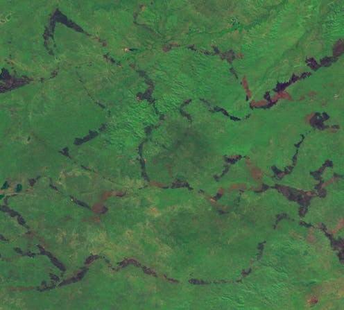
Satellite imagery shows how burnt areas in central Arnhem Land are lines carefully 'painted' across the landscape. Sentinel Hub EO Browser, CC BY

Right now, hundreds of bushfires are burning across northern Australia. But this is not a wildfire catastrophe – in fact, these burns are making things safer in one of the most fire-prone landscapes in the world.

From April to June each year, fire managers – such as Traditional Owners, park rangers and pastoralists – aim to create small, “cool” fires with care and precision to reduce fuel loads before conditions get severe later in the dry season. This work, “painting” landscapes with fire, is constantly informed by satellite data.
Sign up to read this article
Read news from 100's of titles, curated specifically for you.
Already a member? Sign in here
Related Stories
Top stories on inkl right now
One subscription that gives you access to news from hundreds of sites
Already a member? Sign in here
Our Picks
Fourteen days free
Download the app
One app. One membership.
100+ trusted global sources.