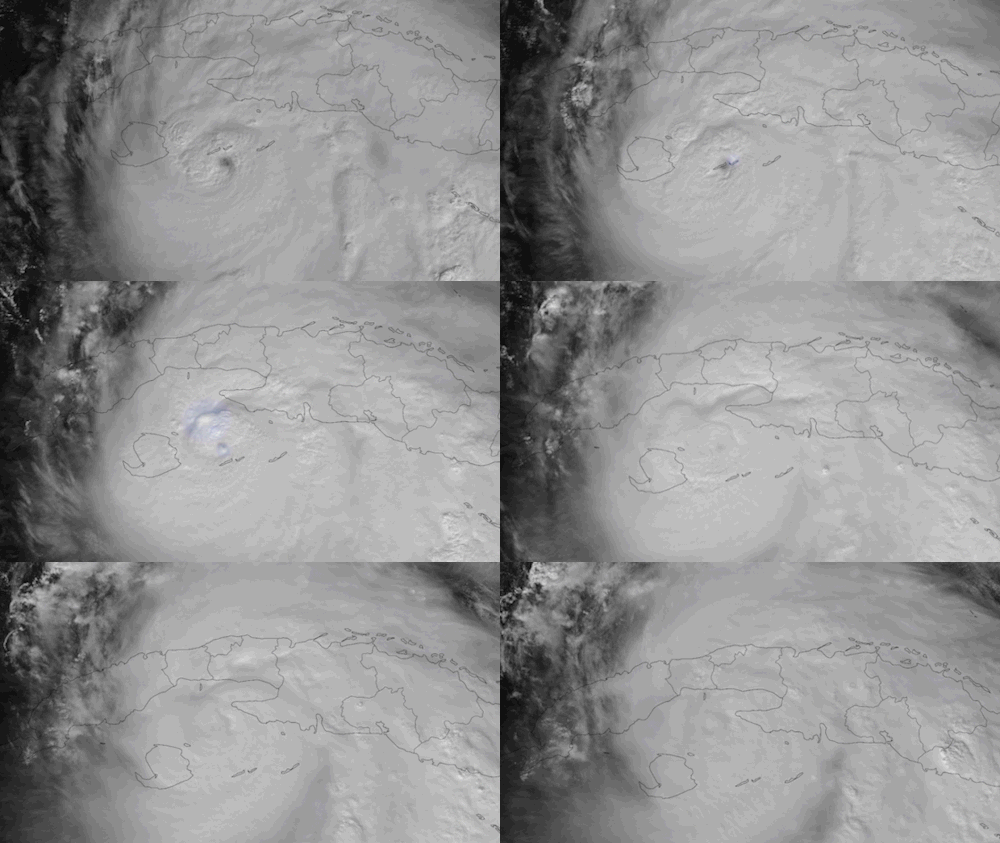
As we go into the final days of November, the National Oceanic and Atmospheric Administration (NOAA)'s GOES-East satellite is busy keeping a watchful eye on what's now the 17th storm of the season.
It's been quite the wild ride lately after what started off as a quieter 2024 hurricane season in the Atlantic. Two previous storms, Hurricane Milton and Hurricane Helene, caused billions in damage and took hundreds of lives throughout the American southeast in September and October. The latest storm, Hurricane Rafael, began its development at the end of October and has now organized more into a tropical system to kick off November. On Nov. 5, it strengthened into a hurricane.
The storm set its sights on Cuba as it moves northwestward just west of Jamaica in the coming days. In the warm waters of the Caribbean Sea, Rafael continued to intensify and reached hurricane status on Nov. 6, making landfall in the Artemisa province of Cuba as a major Category 3 hurricane with sustained winds at 115 miles per hour (185 kilometers per hour) with even stronger gusts.

In the accompanying images captured by NOAA's GOES-East satellite, you can see in high resolution and crisp detail the powerful and large storm tear through the island in the eastern Caribbean. Thanks to this next generation weather satellite, forecasters are able to keep a close eye on the storm every step of the way.
.@NOAA's #GOESEast satellite captured Hurricane #Rafael making landfall earlier today in Cuba's Artemisa province. Latest: https://t.co/ScLdyBaJZb pic.twitter.com/0lKiLRUKijNovember 7, 2024
GOES-EAST is equipped with various products and tools that provide different views of storms, capturing their development in detail. One of the key instruments used by forecasters to get a better understanding of storms is the Advanced Baseline Imager (ABI). The ABI instrument leads the way in detailing storms than the prior GOES satellites, providing three times increased spectral information, four times more spatial resolution, and at five times the speed.
There's a total of sixteen different channels (or bands) including two visible, four near-infrared, and ten infrared. In the above image, ABI Band #2 (visible) is used to monitor clouds at high resolution and paired with ABI #13 (infrared), which is used to show the vertical profile of storms including their temperature and moisture profiles. By using each channel separately or paired with others, forecasters can have a clearer picture of how a storm develops, moves, and intensifies during its lifespan.
With the current forecast track by NOAA's National Hurricane Center (NHC), Rafael is expected to weaken and stay out over the open waters of the Gulf of Mexico through the weekend and take a turn south next week toward Mexico. For the latest updates on Rafael, you can find the latest information on the National Hurricane Center website.


