Get all your news in one place.
100's of premium titles.
One app.
Start reading
The Conversation
The Conversation
Environment
Christine Wiedinmyer, Associate Director for Science at CIRES, University of Colorado Boulder

NOAA’s vast public weather data powers the local forecasts on your phone and TV – a private company alone couldn’t match it

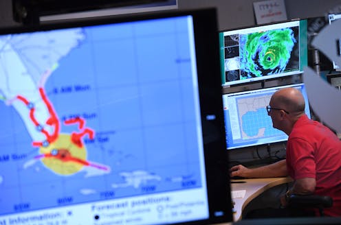
A forecaster monitors incoming data for Hurricane Irma in 2017 at the National Hurricane Center, part of the NOAA. Matt McClain/The Washington Post via Getty Images

When a hurricane or tornado starts to form, your local weather forecasters can quickly pull up maps tracking its movement and showing where it’s headed. But have you ever wondered where they get all that information?

The forecasts can seem effortless, but behind the scenes, a vast network of satellites, airplanes, radar, computer models and weather analysts are providing access to the latest data – and warnings when necessary. This data comes from analysts at the National Oceanic and Atmospheric Administration, known as NOAA, and its National Weather Service.

Sign up to read this article
Read news from 100's of titles, curated specifically for you.
Already a member? Sign in here
Related Stories
Top stories on inkl right now
One subscription that gives you access to news from hundreds of sites
Already a member? Sign in here
Our Picks
Fourteen days free
Download the app
One app. One membership.
100+ trusted global sources.