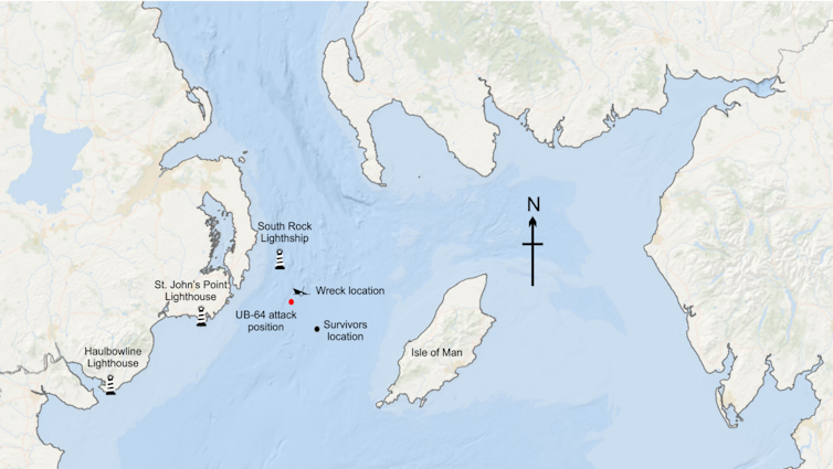
HMS Stephen Furness was steaming through the northern Irish Sea on the afternoon of December 13 1917, en route to Liverpool for repairs. The crew maintained a cautious course, altering direction every ten minutes and travelling at a steady 13 knots – fully aware of the lurking threat from German U-boats.
At 4.15pm, disaster struck. A torpedo launched by the German UB-64 hit the starboard side of the vessel, causing an explosion that sank the ship in just three minutes. Of the more than 100 sailors on board the Stephen Furness, only 12 survived. Clinging to a makeshift raft, the survivors, including Lieutenant P.S. Simmonds, were rescued two hours later by a trawler and brought to safety in Holyhead, north Wales.
For more than a century, the final resting place of HMS Stephen Furness remained a mystery. Simmonds provided an approximate location in his report the following day, but the precise site was never confirmed. Now my colleagues and I believe we’ve found the wreck site about ten miles off the east coast of Northern Ireland.
Our discovery is the result of a massive collaborative effort. At Bangor University, we have developed improved methods for identifying shipwrecks. The Unpath’d Waters project’s goal is to demonstrate the value of connecting marine archives with cutting-edge scientific data.
To pinpoint HMS Stephen Furness and other wrecks in the area, we analysed multi-beam sonar data from every charted site where the ship was reported lost. Collaborating with historians in the Isle of Man, Wales and the US, we accessed an array of historical records. These included vessel plans and the war diary of UB-64.
One wreck matched the dimensions of the Stephen Furness and was located within a few kilometres of the position where UB-64’s commander, Kapitänleutnant Walter Gude, reported firing a torpedo at a green-painted steamer. Both Gude’s and Simmonds’ accounts point to the ship sinking within minutes of the strike.
Previously, this wreck was thought to be the remains of the Swedish cargo vessel Maja, also torpedoed in the area a year later. But our sonar data and archival evidence suggest that a more likely candidate for the Maja lies a few miles to the south.
During our research, we uncovered another fascinating detail. Several casualties from HMS Stephen Furness had washed ashore on the north Wales coast, almost 100 kilometers south, nearly a month after the sinking. This raised an intriguing question – how did they get there? Could these events reveal more about the complex marine systems that govern the fate of shipwrecks and their cargo?

To investigate, we used a technique called “numerical modelling”, typically employed to predict the movement of pollutants, plastics, or even larvae. To reconstruct the sea conditions from the past – known as “hindcasting” – we combined tidal data from December 1917 to January 1918 with archived wind records from the UK Met Office.
Our model recreated the sea surface conditions and mapped the likely drift paths of the victims. The results aligned almost perfectly with the timing and locations of the bodies that washed ashore, providing a compelling case for the accuracy of this method.
This technique has wider implications, offering the potential to revisit other historical maritime incidents where survivor records are the only geographical clues.
The importance of identifying wrecks
Although our findings make the identification of HMS Stephen Furness and Maja far more credible, official recognition often requires physical evidence, such as a ship’s bell.
Nevertheless, our research highlights a broader issue: the unknown identities of thousands of shipwrecks around the UK’s coastline. It often surprises people when they hear that nearly 40% of wrecks in UK waters are listed as “unknown”. Our analysis suggests that up to 30% of identified wrecks may also be incorrectly named.
Read more: How we discovered the wreck of a torpedoed British ship after a 109-year mystery
Shipwrecks are more than just remnants of maritime history. They are vital to understanding our cultural heritage and provide critical insights into marine ecosystems. These sites act as artificial reefs, supporting diverse marine life. They also offer clues about physical and chemical processes in the ocean.
The UK’s seabed holds one of the most fascinating historical jigsaw puzzles imaginable. With advanced sonar technology and archival research as our guide, we can begin piecing together this underwater mystery.
Projects like ours are not just about identifying wrecks. They are also about uncovering stories of human resilience, loss and discovery that continue to shape our understanding of the past – and our relationship with the sea.
Michael Roberts receives funding from Arts and Humanities Research Council.
This article was originally published on The Conversation. Read the original article.


