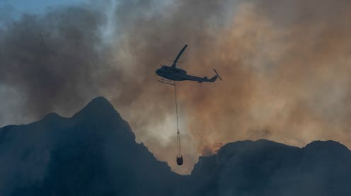
Just over a year ago, a wildfire caused considerable damage to the University of Cape Town and surroundings. Irreplaceable African collections were destroyed. The last active windmill in Africa was severely damaged. Many were surprised by the fire and the widespread damage it caused.
Two previous autumn fires in March 2001 and March 2009 approached the university campus. The 2009 fire even scorched some trees on the campus boundary.
What has been learnt about the risk of a repeat event?
Fire risk is the consequence of interrelated factors and is complex. As part of my PhD research I have examined the relationship between wind and rainfall variability and specifically to the 2015-2017 drought in Cape Town.
In this article I look at some of these factors in relation to the 2021 fire and their potential influence on future events.
Read more: The Table Mountain fire: what we can learn from the main drivers of wildfires
Hot and windy weather during ever drier and warmer autumns after the summer dry season represent a particular risk. Fires around the university are necessary and inevitable, but dense, flammable, often invasive scrub on the campus perimeter and some of the trees around buildings enhance the risk.
But there’s much we don’t know and urgently need to research further.
The event
SANParks, the body responsible for managing South Africa’s national parks, commissioned a study investigating the cause of – and response to – the fire. The study found that it was deliberately started before 9am on 18 April 2021. The suspects were driving on a freeway along Devil’s Peak, the spectacular backdrop to the university jutting out from Table Mountain.
Initially the fire spread slowly in calm conditions. But from 10am conditions suddenly deteriorated as dry, gusty north-westerly winds arrived. The fire intensified and destroyed buildings in the zone where natural areas transition to built up spaces – what’s known as the Wildland Urban Interface.
Fire causes
A recent paper introduces the concept of ignition catchments – roughly, all the places a fire could start from to reach you. The university campus’s catchment is much smaller than it was in pre-colonial times when fires could freely cross the Cape Flats.
During the fire season (roughly December to April), winds mostly come from the south or south-east. South-east of the university lie suburbs which are unlikely to sustain large fires. To the south, the indigenous Afrotemperate Forest of Newlands would likely act as a “natural firebreak”.
Only fires starting in the small grassy area between the forests and the university, invaded by flammable trees, pose a significant risk from the south.
Fires coming downhill from the west would tend to spread more slowly. But under certain conditions, the risk of downhill spotting – fires lit by burning embers shot out ahead of the main fireline –may be greater.
Spotting was responsible for the fire gutting buildings in the middle of campus. It crossed a four-lane highway in multiple places, as fires were lit 350m ahead of the main firefront.
North-westerly winds also pose a considerable fire weather risk for the university. In a recent paper we examined the relationship between wind direction and rainfall in the area. Usually north-westerly winds bring cool, moist and cloudy weather after travelling across the cold Benguela Current along southern Africa’s west coast. Sometimes in autumn, though, such as on the day of the fire, they are hot, dry and gusty.
The wind pattern around Table Mountain is extremely complex. Nearby wind data are hard to obtain, but we do know that at the airport and harbourstations, north-westerly winds gusted to over 40km/h around 2pm.
This led to a very high predicted fire danger index. Near the university, the South African Weather Service recorded maximum temperatures of 35.8°C.
Relative humidity is the other crucial meteorological determinant of fire behaviour. At 11am it was just 10% in town. This is drier than desert air usually is. Such low humidity is known to drive extreme fire behaviour.
Hotter, drier autumns
The three preceding weeks were also unseasonably hot and dry. A very slow-moving regional dome of heat drove this pattern. During April 2021 Cape Town received less than 25% of normal rainfall.
A recent study found a long-term pattern of autumn drying, predicted to get worse with climate change. Dry autumns were associated with a wave-4 pattern in the Southern Hemisphere (four pairs of highs and lows around the hemisphere). It is clearly visible in April 2021 temperature and pressure anomalies (deviations from normal).

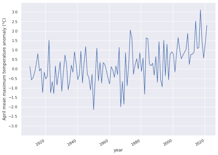
Long-term, continuous temperature data for individual locations in South Africa are very difficult to assemble. In gridded Berkeley Earth maximum temperature data for the area around Cape Town since 1910, the three warmest Aprils were 2014, 2017 and 2021. Other temperature datasets yield similar results. So do nearby station data available since 2000.
Given the findings of recent drought attribution studies for the region, it is likely that the autumn warmth and dryness have become more common recently due to climate change. However, many other variables that are more difficult to analyse also influence plant susceptibility to fire.
Fuels
After the March 2009 fire the University of Cape Town removed some alien trees to reduce fuel loads. It has now removed most of the remaining pine and other alien tree stands along the north-western perimeter of Upper Campus.
Over the past two decades, SANParks has also made significant progress in clearing invasive tree stands. This despite intense opposition, mostly from local recreational users who frequently support “forest” preservation with arguments based on ecological and climatic misconceptions.
However, at the time of the 2021 fire dense stands of flammable, mostly alien shrubs and low trees dominated some areas bordering the campus, particularly in the north where the fire came from. Despite extensive clearing operations since the fire, a dense thicket of invasive alien shrubs and trees is emerging along both sides of the university perimeter. It will need to be monitored as a future fire risk.
The native fynbos and renosterveld vegetation are both fire-prone and fire-dependent, whereas introduced tree and shrub species are also adapted to burning and proliferating rapidly thereafter.
Hence, rapid spread of fire near the University of Cape Town is an ever-present risk once fuel loads are restored.
A longer version of the article can be found here.
Stefaan Conradie received funding from the South African National Research Foundation.
This article was originally published on The Conversation. Read the original article.


