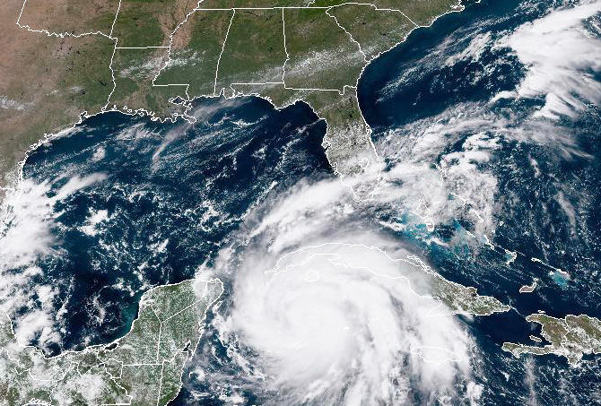
Hurricane Ian was upgraded to a Category 3 hurricane early Tuesday morning ahead of making landfall in western Cuba. This distinction means that the powerful storm is producing winds with speeds between 111 and 129 miles per hour, according to the Saffir-Simpson Hurricane Wind Scale. Such speeds are strong enough to uproot trees and cause major infrastructure damage to buildings and roads, as well as electricity and water sources. And that's not all.
Ian is expected to be the first hurricane to make landfall in Tampa since 1946. In anticipation of this likely devastation, President Joe Biden has reached out to local officials in the Sunshine State. Meanwhile, Gov. Ron DeSantis, R-Fla., has warned residents to brace themselves for power outages, gasoline shortages and downed cell phone towers. He has also declared a statewide emergency, calling attention to the potential for "historic" flooding.
"What we have here is really historic storm surge and flooding potential," DeSantis said at a Tuesday morning news conference. "That storm surge can be life-threatening."
Last year, DeSantis unveiled "Always Ready Florida," a three-year plan to "enhance efforts to protect our coastlines, communities and shores." Yahoo News senior editor David Knowles reported at the time that the governor had taken "pains to keep from framing the plan in terms of climate change mitigation."
"What I've found is when people start talking about things like global warming, they typically use that as a pretext to do a bunch of left-wing things that they would want to do anyways," DeSantis then said. "And so we're not doing any left-wing stuff."
However, a major factor contributing to the rapid intensification of Hurricane Ian is the same one that fueled other destructive storms before it, such as Hurricanes Florence and Maria in the Atlantic Ocean and Hurricane Agatha in the Pacific Ocean. "Rapid intensification" refers to the process in which a storm's maximum sustained winds increase in speed by at least 35 mph in a 24-hour period. According to scientists who spoke with Salon, a significant factor contributing to this series of storms experiencing rapid intensification — if not indeed the main factor — is climate change.
"These storms are on average 20-30% more intense and destructive owing to the roughly 1C (2F) warming of the oceans that has taken place so far."
"These storms are on average 20-30% more intense and destructive, owing to the roughly 1C (2F) warming of the oceans that has taken place so far," Dr. Michael E. Mann, climate scientist and director of the Center for Science, Sustainability and the Media at the University of Pennsylvania, told Salon by email. "They also produce as much as 30% more flooding rainfall due to a combination of more evaporation from a warmer ocean surface and stronger winds that entrain more moisture into the storms."
Susan Buchanan, a spokesperson for the National Weather Service, told Salon by email that when you consider the dynamics of climate change — specifically how it causes the surface ocean to warm, which then can be expected to fuel more powerful tropical storms — it suggests Americans are going to have a worsening problem with severe storms.
"The proportion of Category 4 and 5 tropical cyclones has increased, possibly due to climate change, and is projected to increase further," Buchanan said, referring to storms with winds from 130 to 156 mph (Category 4) or in excess of 156 mph (Category 5). "In addition, the atmosphere is holding more moisture due to climate change, so these large storms are creating heavier rainfall. These torrential downpours are leading to more coastal and inland flash flooding and river floods."
Buchanan also noted that rising sea levels, which are caused by climate change, cause stronger storm surges and increase flooding hazards in coastal communities. At the same time, she qualified her assessment by noting that "any single weather event needs to be studied after it's over by climate scientists to make this determination."
To be clear, climate change is not alone in worsening the impact of superstorms such as Hurricane Ian. Kevin Trenberth of the National Center for Atmospheric Research (NCAR) told Salon by email that La Niña — a weather pattern that occurs naturally in the Pacific Ocean — is also playing a role here.
"The environment Ian is occurring in has definitely changed because of climate change," Trenberth told Salon by email. "There is also a natural variability component, especially the La Niña in place. Sea surface temperatures are higher, ocean heat content is higher and sea level is higher." As a result, Trenberth noted that there is now roughly 10 to 15% more moisture in the atmosphere, which becomes excess rainfall and worsens the storm.
In the case of Hurricane Ian, scientists and public officials agree that it will be necessary for Floridians to take certain safety precautions. Mann told Salon that much will depend on the storm's exact path, which remains uncertain.
"Even people outside the immediate impact area could receive high winds and heavy rainfall."
"A worst-case scenario is that the storm travels right past Tampa paralleling the coast, driving a storm surge of 12 feet or more," Mann said. "Owing to the long shallow coastal shelf and extensive low-lying coastline, the storm surge combined with inland flooding from heavy rainfall could displace millions of people. I warned of such a scenario a few years ago in the Tampa Bay Times."
Rather than waiting until a storm is bearing down, Buchanan would advise individuals to begin making preparations in advance of each hurricane season. When a storm approaches, it's imperative to listen to emergency officials, including evacuating if necessary; staying off the roads during and after the storm; preparing emergency kits that include food, water, medications and other basic supplies; keeping electronic devices charged in case of lost power; and reviewing insurance policies, among other things.
"Even people outside the immediate impact area could receive high winds and heavy rainfall," Buchanan pointed out, saying that even individuals in those areas can prepare by trimming large branches which could be knocked down, securing their outdoor property and checking on loves ones like elderly individuals and pets.


