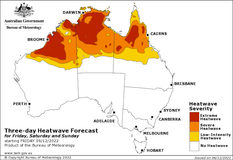
After a wet and unusually cool spring for much of Australia, the start of meteorological summer is bringing a heatwave to the north of the continent. Even in our La Niña summer we can expect spells of heat, and it’s important to heed health warnings and take the hot weather seriously.
Heat is building across northern Australia and the area may see temperatures over 40℃ for the next few days. Some parts will experience temperatures more than 5℃ above average. These are quite big departures for tropical regions, which normally experience less variable temperatures than places such as Melbourne or Adelaide.

Read more: Melbourne now has chief heat officers. Here's why we need them and what they can do
Relief from the heat is expected early next week as more moisture allows wetter conditions, which will cool things back down.
As a La Niña event continues, people may be surprised to see a major heatwave in northern Australia. La Niña brings generally wetter and cooler conditions. However, there are other climate influences on Australia that can counteract its effects, and weather systems can still bring heat to the continent.
The negative Indian Ocean Dipole, which was combining with La Niña to provide the ingredients for a wetter-than-normal spring, has dissipated. The Madden-Julian Oscillation, which is a pulse of enhanced cloud followed by clearer skies that moves from west to east near the equator, is not very strong at the moment. This allows drier conditions conducive to heat to build over the north of the continent.
Extreme heat is dangerous, especially after cool periods
Since the Black Summer bushfires of 2019-20, much of Australia has experienced what has felt like never-ending rains, but we must always be prepared for heatwaves. Extreme heat is very harmful to human health. It’s a bigger killer than floods and other weather extremes in Australia.
It is important for people to heed warnings about staying cool and hydrated during heatwaves. Each state and territory has handy advice to follow, including the Northern Territory, Queensland and Western Australia, which are affected by the current heatwave.
Read more: Heat kills. We need consistency in the way we measure these deaths
Extreme heat is especially dangerous when it follows a period of cooler weather. For those of us in the south of the country, you may have noticed the first really hot day of summer feels more extreme than a day with the same temperatures in February or March. This is because the human body takes time to acclimatise to the heat.
We see worse health impacts from extreme heat early in the warm season. This is why the Bureau of Meteorology incorporates recent temperatures into its heatwave forecasts and alerts.
What will the rest of summer bring?
The La Niña that helped set up the cool and wet spring conditions over most of Australia is predicted to ease very soon. There is high uncertainty, though, and some forecast models predict the La Niña will last a bit longer. Predicting the end of these events is tricky, so forecasts aren’t always correct.
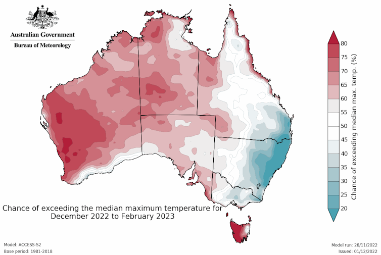
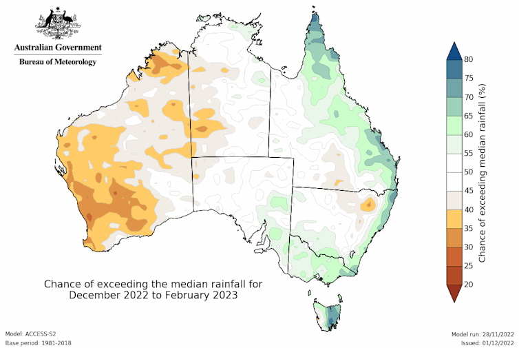
With a weakening La Niña, the summer outlook is for warmer daytime conditions away from the east of Australia and the rainfall signal is no longer very strong.

Rainfall outlooks, though, are generally less reliable in summer than at other times of year. This is because more of our summer rain is from storms, and it’s hard to predict ahead of time where these will occur. Less of our rain is from fronts and large-scale weather systems compared with cooler times of year.
Read more: ‘A cunning plan’: how La Niña unleashes squadrons of storm clouds to wreak havoc in your local area
This summer, more tropical cyclones are forecast in the Australian region. Depending on where exactly they form and track, we might see some places experiencing huge amounts of rain while others miss out.

Expect more heatwaves
In any summer, parts of Australia will experience extreme heat. There are some places that, perhaps counter-intuitively, experience more heatwaves in a La Niña summer, including Victoria.
Human-caused climate change is also bringing more frequent and intense heatwaves to the continent and pretty much the whole world. We have increased the odds of having extreme heat events in Australia through humanity’s ever-increasing greenhouse gas emissions. This means we must be prepared for more heat regardless of what’s going on with the El Niño-Southern Oscillation or other climate influences.
We need to be prepared for different types of extreme weather over the summer. Wherever you are in Australia, it is important to keep up-to-date with the weather forecasts over the next few months.
Read more: State of the climate: what Australians need to know about major new report
Andrew King receives funding from the National Environmental Science Program.
This article was originally published on The Conversation. Read the original article.


