Firefighters in Denver rescued multiple people from their vehicles Sunday night, as the National Weather Service warned monsoonal showers and thunderstorms could trigger flash flooding and "debris flows" from the Four Corners region into the Southwest.
The big picture: Flood-ravaged Kentucky was still under threat from another deluge, as President Biden and first lady Jill Biden prepared to visit the state, in response to at least 37 people being killed in last week's catastrophic flooding in the Appalachia.
- The NWS in Jackson said there's "a persistent threat of thunderstorms" for the area this week, in fact all the way through Sunday, which "could bring locally heavy rainfall, leading to potential high water issues."
- The NWS Weather Prediction Center (WPC) issued a forecast Monday morning putting eastern Kentucky at a "slight" risk for excessive rainfall on Tuesday, which is a level 2 out of 4 on the alert scale.
- Forecasters highlighted unusually high moisture levels in the atmosphere and the threat of slow-moving thunderstorms as potential flash flood threats.
- "Unfortunately, any flash flooding on Tuesday will prime many of the same areas for potentially worse and more widespread flash flooding on Wednesday," the NWS wrote.
Meanwhile, the Denver Fire Department told 9News a baby was among at least 19 people rescued during thunderstorms that triggered heavy rains and flooding in Denver-area streets, forcing the closure of parts of Interstate 25.
- Showers and "a few storms" were lingering in several places in the Denver area overnight, said the NWS in a tweet warning urging drivers to "avoid driving on flooded roadways."
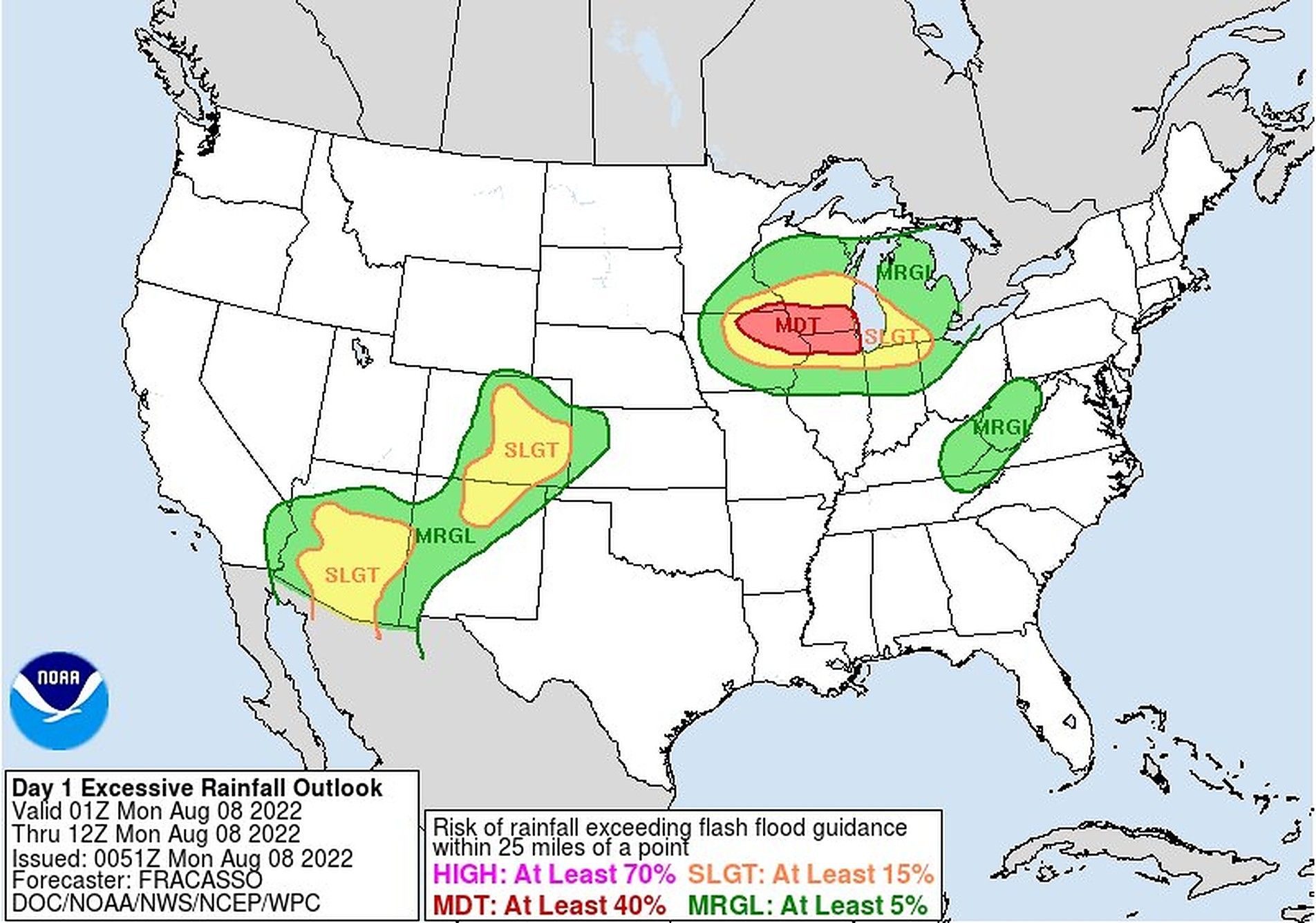
Threat level: "Moisture pooling along the front will aid in producing showers and thunderstorms over parts of the Great Lakes/Upper Mississippi Valley to the Central High Plains that will move eastward with the front through Tuesday," according to the NWS Weather Prediction Center.
- "Some of the storms will produce heavy rain," the forecast added.
Of note: Flash flood warnings were in effect across parts of the Great Lakes Monday morning, with heavy rain falling in northern Illinois and southern Wisconsin. Flash flooding is ongoing in these areas.
- The WPC said there's a slight risk of excessive rainfall and, consequently, flash flooding over parts of the Southwest and parts of the central and southern Rockies and Central High Plains through Monday morning.
Context: Climate change is ratcheting up the severity of extreme weather events like extreme rainfall events, per Axios' Andrew Freedman.
Go deeper: We haven't built for this climate
Editor's note: This story has been updated with new forecast details throughout.