May’s record-breaking heatwave will be brought to an abrupt end by torrential downpours that is set to see Britain lashed by two days of heavy rain.
The Met Office said Saturday officially marked the end of the sweltering weather, and scattered showers and lower temperatures on Sunday made way for more changeable weather this week.
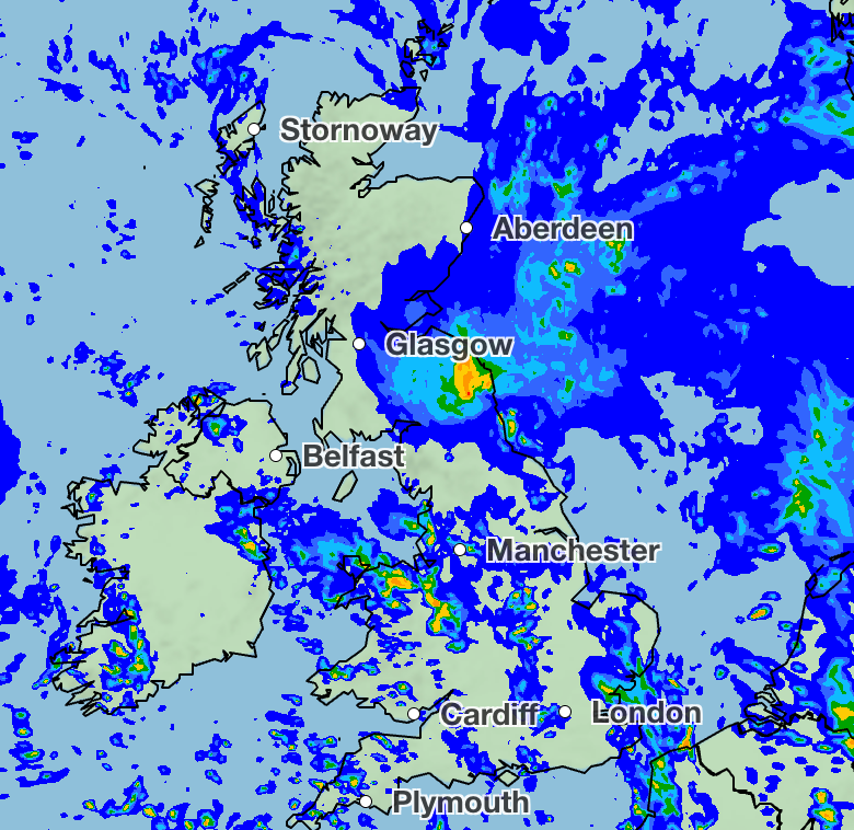
Maps from the forecaster show a blanket of heavy rain stretching across the UK, which could see between 2mm and 16mm dumped on some areas every hour.
The drenching will cover northern and western areas on Monday morning, moving eastward across the country before easing on Tuesday.
Scotland will see particularly heavy rain on Tuesday, with deluges of up to 16mm per hour in the afternoon.
Met Office chief forecaster Chris Bulmer said: “Temperatures should be much closer to average for the time of year with accompanying rainfall for many through the weekend and into the start of next week.”
Spells of rain will move across the UK, expected to be heavy at times across the west, broken up with brighter intervals.
Temperatures are expected to come back down to the average for this time of the year when compared with the excessive heat recently seen.
Meteorologist Kathryn Chalk said in the latest forecast: “As we go through Monday, another area of low pressure arrives from the west, bringing outbreaks of rain.
“This rain might actually be some welcome rainfall, especially for farmers and gardeners. As that clears its way through into Tuesday, it'll be a day of sunny spells and frequent showers.”
By 10pm on Tuesday, the rain will have cleared up into small patches of drizzle, according to the forecast.
Patchier showers are expected on Thursday, mostly in the morning in northern and eastern areas.
The mercury is set to drop to the late teens and early twenties, a marked difference from the sweltering highs the UK has seen over the past week.
It comes after the forecaster marked record-breaking temperatures for May with a scorching 35.1C recorded in Kew Gardens on Tuesday. This broke the record set the day before at 34.8C; originally, the highest May temperature had been 32.8C, recorded in 1922 and 1944.
Further unsettled conditions are predicted throughout the week, with spells of rain, showers and thunderstorms and a chance of hail in parts.
Met Office five-day forecast for the UK
Today:
Early sunny spells in the east turn cloudier with heavy rain spreading north and east. Rain persistenting in the west, which can be heavy in places. Sunny spells return to Northern Ireland later. Temperatures just above the seasonal average.
Tonight:
Rain moving eastwards, heavy at times, especially southeast by the morning. Showers developing in the west with the risk of thunder. Low cloud and coastal fog further north. Mild.
Tuesday:
Heavy showers and thunder across the south and east, where it can be gusty. Drier spells developing in the west later with some sunnier spells. Temperatures around average for June.
Outlook for Wednesday to Friday:
A changeable week to come with showers and longer spells of rain, but some sunnier spells in between. Temperatures much closer to average, or even just below.