Extreme weather conditions are lingering across parts of Australia as crews fight to contain bushfires in multiple states.
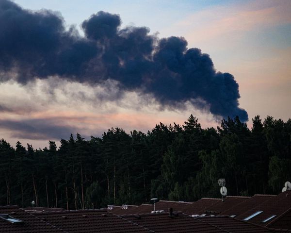
Across New South Wales, more than 75 fires were burning on Saturday afternoon, with 19 yet to be contained. At least a dozen homes were destroyed by a fire burning at Koolewong on the Central Coast, with an emergency warning issued by the Rural Fire Service in place as of 5pm on Saturday.
The Koolewong fire was burning quickly and had spotted into the Woy Woy bay area, the RFS said.
“We’ve got reports of more than 12 houses lost unfortunately,” said Leigh Pilkington, an RFS assistant commissioner, on the ABC. “We’ve got more than 250 firefighters, more than 50 fire trucks and other appliances, nine aviation assets, aircraft and doing what we can to keep this under control.
A second emergency warning was issued on Saturday afternoon for a fire at Milsons Gully in the upper Hunter region, with more than 9,000 hectares burned.
Another bushfire in the Goulburn River national park in the Merriwa River valley area had burned 8,600 hectares but the RFS said on Saturday afternoon it was under control.
Several more properties were thought to have burned at Bulahdelah, north of Newcastle, although fire assessors were yet to survey the full extent of the damage.
The prime minister, Anthony Albanese, said in a statement he was “thinking of all those across NSW impacted by today’s bushfires”.
“Please look out for each other and follow advice from authorities. Thank you to all our emergency services and volunteers on the ground and in the air.”
Dangerous fire conditions were expected to continue across parts of eastern Australia as forecast dry lightning risked new blazes.
In Tasmania, more than a dozen homes and shacks, outbuildings and cars were damaged and two firefighters were injured fighting a fire at Dolphin Sands on the east coast, which had been burning since Thursday.
A Tasmania Fire Service spokesperson said on Saturday afternoon the fire conditions were abating and frontline responders were expecting the blaze to come under control soon.
“We’ve seen more friendly conditions for crews to get in and start working on containing the live edge,” he said. “We are expecting a cool westerly change later in the afternoon, which will help us further.”
There had been no significant change in the size of the fire, which had burnt 700 hectares, the spokesperson said.
Some residents will be without power for a week after TasNetworks confirmed severe fire damage to dozens of power poles in the Dolphin Sands area.
In Victoria, firefighters had contained a bushfire in Markwood, 280km north-east of Melbourne, which had affected at least three properties.
Heatwave conditions across the country
Severe heatwave warnings were in place in parts of NSW, Queensland, the Northern Territory and Western Australia.
Severe heatwave conditions in NSW spanned eastern parts of the state and extended from the Hunter region to the south coast.
The Bureau of Meteorology warned temperatures were expected to rise quickly on Saturday, peaking at 39C in the Sydney CBD but above 40C in the western suburbs.
“We are seeing that heat building over a couple of days,” Christie Johnson, a BoM senior meteorologist, said. “Often the third day is the most dangerous day for heatwave conditions.”
The hot, dry, and windy conditions had pushed fire danger ratings to extreme in several districts, including Sydney, the Hunter and the Illawarra, prompting the Rural Fire Service to issue total fire bans for many areas.
Sign up: AU Breaking News email
Nationally, severe heatwave warnings were in place for parts of north-western Queensland and the NT, while extreme heatwave warnings in WA covered the Kimberley, Pilbara and northern interior.
Relief expected
In NSW, relief was expected to arrive on Saturday night, with a cool southerly change forecast to sweep up the coast overnight and reach Sydney early Sunday morning.
“It’s going to remain hot in north-eastern NSW but the rest of the state will see a much cooler day tomorrow,” Johnson said.
But damaging wind gusts and thunderstorms were possible across central and eastern NSW on Saturday afternoon, carrying an increased risk of dry lightning igniting new fires.
Victoria and Tasmania were experiencing a cold front with much cooler temperatures, showers, isolated thunderstorms and even possible snow as low as 700 metres over Tasmania by Saturday night. A severe weather warning had been issued for the Eastern Alps in Victoria.
Temperatures were expected to ease on Sunday.
Extreme and unstable weather was a harbinger for what Australians could expect this summer, senior BoM meteoteorologist Dean Narramore told the ABC on Saturday.
“Unfortunately, we’re going to see more of this,” he said. “A cool change comes through for most of NSW and southern Australia through Sunday, Monday. The heat builds further across northern Australia as we get into earlier mid-next week … and will return to much of the country late next week.
“We’re in that cycle now with heat continuing to move around the country.”