At least seven people have died and scores more were injured or missing after flash floods inundated Sikkim on October 4. The floods are believed to have been triggered after a lake, forming from the gradual melting of a Himalayan glacier, suddenly overflowed and inundated the Teesta river basin.
This destroyed the Chungthang dam, a key component of the State’s largest hydroelectric project, and washed away highways, villages, and towns. The worst affected districts were Mangan, Gangtok, Pakyong, and Namchi. Twenty-two Army personnel were among those reported missing.

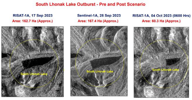
The South Lhonak lake in northern Sikkim is situated about 5,200 metres above sea level. Scientists have previously warned that the lake had been expanding over years, possibly from the melting of the ice at its head. Nearly half the lake was drained out, according to a press statement by the National Disaster Management Agency (NDMA). This was likely caused by an “avalanche from the ice-capped feature.”
Significant damage
The Chungthang dam, a concrete-rock dam, was breached from its centre from the sheer force and speed of the water, estimated at nearly 54 kmph.
“There is significant damage. However as of [Wednesday evening], the water from the lake has receded. It was a 160-hectare glacial lake and now it is about 60 hectares. So all that water has flowed down. Rains are expected for the next two days. Currently, the dam and its surroundings are inaccessible and it will be a few days before we get greater clarity,” a top official in government, who declined to be identified, told The Hindu.
“The distance between the lake and the Teesta 3 [power project] is very short. The CWC [Central Water Commission] reported a rising column of water at 1:30 a.m., but it was so quick and big that little could be done by way of warning,” the official added.
The CWC’s river monitoring stations reported that the first surge of water was nearly 60 feet above the maximum water level at Sangkalang at 1:30 a.m.
The Teesta 3 hydropower project is operated by Sikkim Urja, which is 60% owned by the Sikkim government.
Rescue operations
A number of people are now in relief camps. Twenty-three Army personnel initially went missing at Bardang near Singtam due to the flash flood in the Teesta river, according to a defence spokesperson in Guwahati. One of the 23 missing soldiers was rescued late in the evening. His condition is stable and he is under medical care, an Army official said.
Search operations continued through the day but were hindered due to continuous rain and inclement weather, officials said. The flooding and rain has washed out roads and bridges at several places leading to the border, they added.
“More than 8,000 cubic metres per second of water has been released from Teesta barrage which has resulted in flood-like situations in the downstream districts of Kalimpong, Darjeeling, Jalpaiguri and Cooch Behar,” a press statement from the West Bengal government said.
West Bengal Chief Minister Mamata Banerjee held a discussion with senior officials of the State government and expressed her grief over people including army personnel being washed away. She added that three unidentified bodies were found in the river in West Bengal.
Scientists’ warnings
Scientists at the Indian Institute of Science (IISc) in Bengaluru and the Indian Space Research Organisation (ISRO), through multiple studies in 2013 and 2019, have warned that the South Lhonak lake was “potentially hazardous” and cautioned the authorities to keep an eye on it as it was expanding “dangerously.”
“In our study in 2013, satellite data analysis showed the glacier receded 1.9 km from 1962 to 2008 and the formation of a moraine-dammed glacial lake at the snout of South Lhonak glacier, Sikkim Himalaya,” said Remya S.N., Assistant Professor at the Amrita Vishwa Vidyapeetham who was part of an IISc team studying Himalayan glacial lakes in 2013.
Glacial lake outburst floods (GLOF), as such events are called, are a major concern in Bhutan, Tibet, India, Nepal, and Pakistan. The IISc study had recommended measures like early warning systems and mitigation measures to be put in place in potential GLOF areas, Dr. Remya added.
In another study in 2019, she found nine potential lake sites, including further expansion of four existing glacier lakes. “After our research paper was out in 2013, the Department of Science and Technology took an initiative to monitor this lake,” she said.
The Himalayas are estimated to have about 7,500 lakes, of which nearly 10% are in Sikkim.
The Lhonak lake overflow is reminiscent of the 2021 deluge that resulted from an avalanche involving the Nanda Devi glacier in the Himalayas that flooded the Rishiganga river in Uttarakhand and washed away at least two hydroelectric power projects — the 13.2 MW Rishiganga hydroelectric power project, and the Tapovan project on the Dhauliganga river, a tributary of the Alakananda. At least 40 people were killed.
(With inputs from Dinakar Peri in New Delhi and Shiv Sahay Singh in Kolkata)


